Property Record
3586 Buford Hwy, Duluth, GA 30096

NEARBY LISTINGS FOR SALE OR LEASE
Property Detail
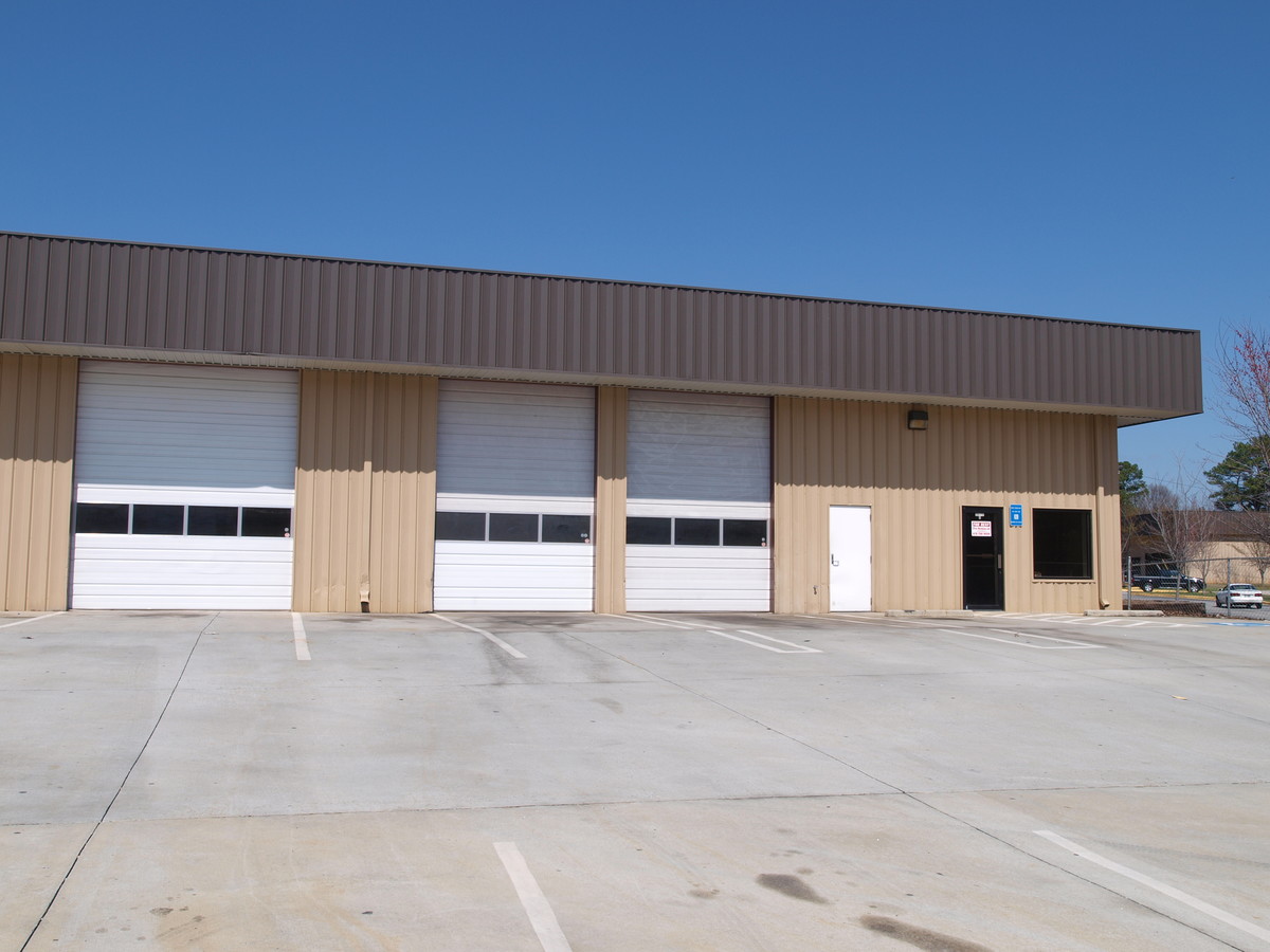
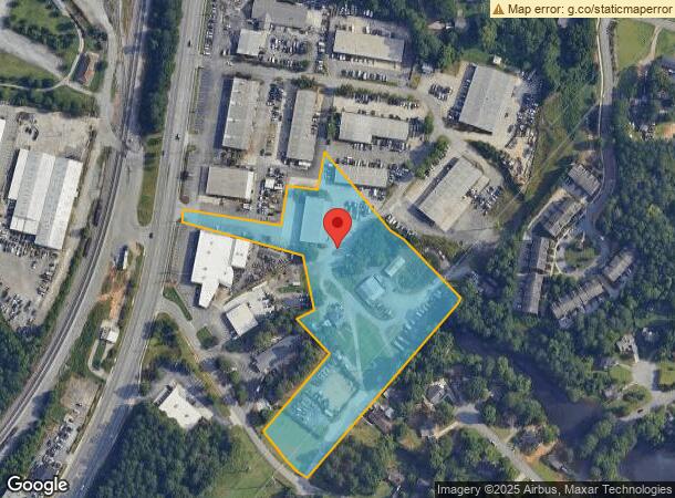
3586 Buford Hwy
6-265-093
US HWY 23
Autorepair
Gwinnett
X
Georgia
13135C0069F
6.25 AC
2023
Gwinnett Mall/Duluth
2023
Atlanta
050218
Atlanta-Sandy Springs-Roswell, GA
18,816 SF
DEMOGRAPHICS near 3586 Buford Hwy
1 Mile
3 Mile
5 Mile
2024 Total Population
10,326
76,031
220,723
2029 Population
10,780
79,601
229,709
Pop Growth 2024-2029
+ 4.40%
+ 4.70%
+ 4.07%
Average Age
38
38
37
2024 Total Households
3,961
28,512
79,848
HH Growth 2024-2029
+ 4.39%
+ 4.75%
+ 4.15%
Median Household Inc
$65,678
$70,798
$70,302
Avg Household Size
2.60
2.60
2.70
2024 Avg HH Vehicles
2.00
2.00
2.00
Median Home Value
$269,813
$333,421
$374,709
Median Year Built
1991
1993
1994
Nearby Places
- Restaurants
- Banks
- Shops
- Fitness
- Groceries
PUBLIC TRANSPORTATION
AIRPORT
Hartsfield - Jackson Atlanta International
DRIVE
WALK
Distance
Hartsfield - Jackson Atlanta International
49 min
34.0 mi
Freight Ports
Georgia Ports - Savannah
DRIVE
WALK
Distance
Georgia Ports - Savannah
305 min
268.9 mi
Nearby Properties
Address
Land Use
TOTAL SIZE
Lot Size
Zoning
Address
Land Use
TOTAL SIZE
Lot Size
Zoning
652,108 SF
78.64 AC
PUD
Address
Land Use
TOTAL SIZE
Lot Size
Zoning
344,203 SF
17.05 AC
MUR
Address
Land Use
TOTAL SIZE
Lot Size
Zoning
491,482 SF
41.72 AC
C1
Address
Land Use
TOTAL SIZE
Lot Size
Zoning
42,372 SF
41.78 AC
RM13-MULTI
Address
Land Use
TOTAL SIZE
Lot Size
Zoning
631,710 SF
65.19 AC
RM13
Address
Land Use
TOTAL SIZE
Lot Size
Zoning
20,896 SF
38.74 AC
RM13-MULTI
Address
Land Use
TOTAL SIZE
Lot Size
Zoning
501,022 SF
40 AC
RM13
Address
Land Use
TOTAL SIZE
Lot Size
Zoning
272,196 SF
44.76 AC
RM13
Address
Land Use
TOTAL SIZE
Lot Size
Zoning
421,088 SF
40.47 AC
RM
Address
Land Use
TOTAL SIZE
Lot Size
Zoning
450,095 SF
45.79 AC
RM10
Address
Land Use
TOTAL SIZE
Lot Size
Zoning
300,735 SF
21.95 AC
PUD
Address
Land Use
TOTAL SIZE
Lot Size
Zoning
315,806 SF
13.03 AC
MUR
Address
Land Use
TOTAL SIZE
Lot Size
Zoning
324,001 SF
11.64 AC
PUD
Address
Land Use
TOTAL SIZE
Lot Size
Zoning
361,593 SF
13.35 AC
RM24
Address
Land Use
TOTAL SIZE
Lot Size
Zoning
421,755 SF
49.61 AC
RM13
Address
Land Use
TOTAL SIZE
Lot Size
Zoning
228,295 SF
9.53 AC
RM24
Address
Land Use
TOTAL SIZE
Lot Size
Zoning
347,203 SF
42.88 AC
RM13
Address
Land Use
TOTAL SIZE
Lot Size
Zoning
357,430 SF
47.93 AC
RM
Address
Land Use
TOTAL SIZE
Lot Size
Zoning
323,846 SF
24.89 AC
PUD
Address
Land Use
TOTAL SIZE
Lot Size
Zoning
304,001 SF
32 AC
PUD
Address
Land Use
TOTAL SIZE
Lot Size
Zoning
237,864 SF
5.09 AC
PUD
Address
Land Use
TOTAL SIZE
Lot Size
Zoning
341,506 SF
36.69 AC
C1
Address
Land Use
TOTAL SIZE
Lot Size
Zoning
244,270 SF
20.14 AC
RM10
Address
Land Use
TOTAL SIZE
Lot Size
Zoning
217,080 SF
49.32 AC
M1
Address
Land Use
TOTAL SIZE
Lot Size
Zoning
254,048 SF
28.59 AC
RM
Address
Land Use
TOTAL SIZE
Lot Size
Zoning
285,038 SF
1.93 AC
MUR
Address
Land Use
TOTAL SIZE
Lot Size
Zoning
347,940 SF
46.73 AC
OI
Address
Land Use
TOTAL SIZE
Lot Size
Zoning
287,824 SF
31.59 AC
RM
Address
Land Use
TOTAL SIZE
Lot Size
Zoning
201,795 SF
22.03 AC
RM
Address
Land Use
TOTAL SIZE
Lot Size
Zoning
202,674 SF
8.42 AC
PUD-PLANNE
The World's #1 Commercial Real Estate Marketplace
Connect with us
© 2025 CoStar Group
The information above has been obtained from sources believed reliable. While we do not doubt its accuracy we have not verified it and make no guarantee, warranty or representation about it. It is your responsibility to independently confirm its accuracy and completeness. Any projections, opinions, assumptions, or estimates used are for example only and do not represent the current or future performance of the property. The value of this transaction to you depends on tax and other factors which should be evaluated by your tax, financial, and legal advisors. You and your advisors should conduct a careful, independent investigation of the property to determine to your satisfaction the suitability of the property for your needs.