Property Record
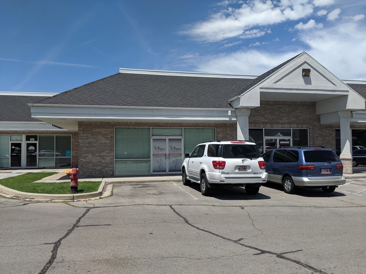
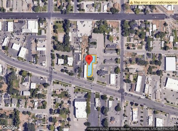
359 E State Rd, American Fork, UT 84003

NEARBY LISTINGS FOR SALE OR LEASE
Property Detail
359 E State Rd
Salt Lake City
Phase I Ameded Amended
Provo-Orem, UT
LOT 2 ALPINE SQUARE PUD PHASE 1 AMD AMD SUB AREA 0.301 AC
34-295-0002
Utah
Officebuilding
Utah
2024
2
2024
0.30 AC
000203
Utah County
13,212 SF
DEMOGRAPHICS near 359 E State Rd
1 Mile
3 Mile
5 Mile
2024 Total Population
16,513
80,539
163,294
2029 Population
19,343
94,274
190,620
Pop Growth 2024-2029
+ 17.14%
+ 17.05%
+ 16.73%
Average Age
33
33
32
2024 Total Households
5,449
23,809
45,600
HH Growth 2024-2029
+ 17.47%
+ 17.47%
+ 17.17%
Median Household Inc
$71,649
$91,234
$101,638
Avg Household Size
3.00
3.30
3.50
2024 Avg HH Vehicles
2.00
2.00
2.00
Median Home Value
$402,336
$469,400
$498,022
Median Year Built
1997
2001
2001
Nearby Places
- Restaurants
- Banks
- Shops
- Fitness
- Groceries
PUBLIC TRANSPORTATION
COMMUTER RAIL
American Fork Station (FrontRunner - Utah Transit Authority (UTA))
DRIVE
WALK
Distance
American Fork Station (FrontRunner - Utah Transit Authority (UTA))
5 min
2.0 mi
Vineyard Station (FrontRunner - Utah Transit Authority (UTA))
DRIVE
WALK
Distance
Vineyard Station (FrontRunner - Utah Transit Authority (UTA))
10 min
7.2 mi
AIRPORT
Provo Municipal
DRIVE
WALK
Distance
Provo Municipal
21 min
15.1 mi
Freight Ports
Port of Stockton
DRIVE
WALK
Distance
Port of Stockton
744 min
726.5 mi
SALE & LEASE HISTORY
LISTING DATE
SALE/LEASE

Sep 25, 2016
For Lease
Oct 14, 2019
For Lease
May 19, 2021
For Lease
Jun 14, 2022
For Lease
Jun 13, 2019
For Lease
Jan 24, 2018
For Sale
Jan 22, 2019
For Lease
Feb 26, 2020
For Lease
Dec 28, 2018
For Lease
Dec 04, 2018
For Sale
Nearby Properties
Address
Land Use
TOTAL SIZE
Lot Size
Zoning
Address
Land Use
TOTAL SIZE
Lot Size
Zoning
189,254 SF
48.27 AC
Address
Land Use
TOTAL SIZE
Lot Size
Zoning
199,783 SF
17.96 AC
Address
Land Use
TOTAL SIZE
Lot Size
Zoning
271,299 SF
19.66 AC
Address
Land Use
TOTAL SIZE
Lot Size
Zoning
194,977 SF
8.18 AC
Address
Land Use
TOTAL SIZE
Lot Size
Zoning
139,105 SF
8.96 AC
Address
Land Use
TOTAL SIZE
Lot Size
Zoning
156,242 SF
8.10 AC
Address
Land Use
TOTAL SIZE
Lot Size
Zoning
Address
Land Use
TOTAL SIZE
Lot Size
Zoning
154,800 SF
9.14 AC
Address
Land Use
TOTAL SIZE
Lot Size
Zoning
144,310 SF
6.85 AC
Address
Land Use
TOTAL SIZE
Lot Size
Zoning
124,460 SF
6.46 AC
Address
Land Use
TOTAL SIZE
Lot Size
Zoning
146,939 SF
36.63 AC
Address
Land Use
TOTAL SIZE
Lot Size
Zoning
Address
Land Use
TOTAL SIZE
Lot Size
Zoning
223,967 SF
21.91 AC
Address
Land Use
TOTAL SIZE
Lot Size
Zoning
52,460 SF
12.78 AC
Address
Land Use
TOTAL SIZE
Lot Size
Zoning
206,405 SF
11.71 AC
Address
Land Use
TOTAL SIZE
Lot Size
Zoning
141,635 SF
10.58 AC
Address
Land Use
TOTAL SIZE
Lot Size
Zoning
194,852 SF
10.03 AC
Address
Land Use
TOTAL SIZE
Lot Size
Zoning
230,702 SF
11.85 AC
Address
Land Use
TOTAL SIZE
Lot Size
Zoning
102,751 SF
6.20 AC
Address
Land Use
TOTAL SIZE
Lot Size
Zoning
13,248 SF
14.61 AC
Address
Land Use
TOTAL SIZE
Lot Size
Zoning
83,049 SF
12.07 AC
Address
Land Use
TOTAL SIZE
Lot Size
Zoning
11,389 SF
13.08 AC
Address
Land Use
TOTAL SIZE
Lot Size
Zoning
112,544 SF
11.96 AC
Address
Land Use
TOTAL SIZE
Lot Size
Zoning
5,268 SF
13.12 AC
Address
Land Use
TOTAL SIZE
Lot Size
Zoning
253,855 SF
29.53 AC
Address
Land Use
TOTAL SIZE
Lot Size
Zoning
148,812 SF
13.49 AC
Address
Land Use
TOTAL SIZE
Lot Size
Zoning
109,875 SF
5.43 AC
Address
Land Use
TOTAL SIZE
Lot Size
Zoning
143,438 SF
7.43 AC
Address
Land Use
TOTAL SIZE
Lot Size
Zoning
46,212 SF
8.97 AC
Address
Land Use
TOTAL SIZE
Lot Size
Zoning
92,397 SF
9.53 AC
The World's #1 Commercial Real Estate Marketplace
Connect with us
© 2025 CoStar Group
The information above has been obtained from sources believed reliable. While we do not doubt its accuracy we have not verified it and make no guarantee, warranty or representation about it. It is your responsibility to independently confirm its accuracy and completeness. Any projections, opinions, assumptions, or estimates used are for example only and do not represent the current or future performance of the property. The value of this transaction to you depends on tax and other factors which should be evaluated by your tax, financial, and legal advisors. You and your advisors should conduct a careful, independent investigation of the property to determine to your satisfaction the suitability of the property for your needs.