Property Record
3600 S Dort Hwy, Flint, MI 48507
NEARBY LISTINGS FOR SALE OR LEASE
Property Detail
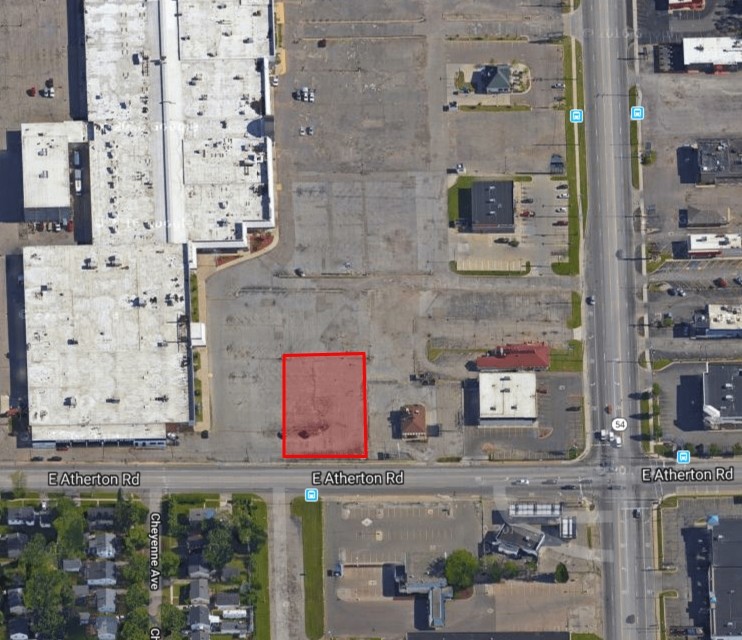
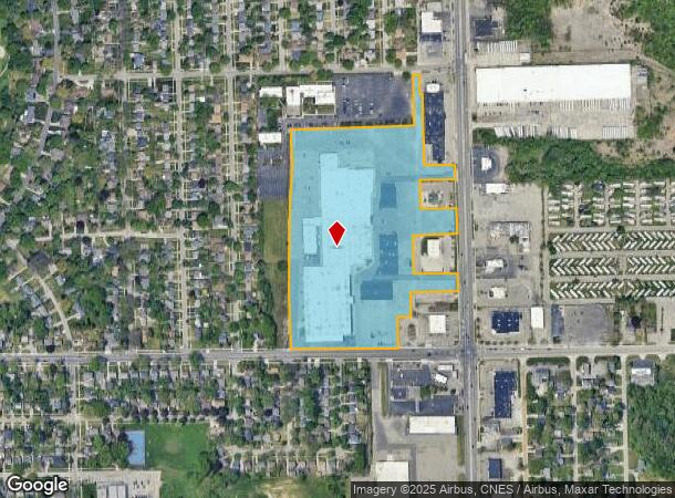
3600 S Dort Hwy
Flint, MI
Dort Atherton Theater
41-20-476-060
UNPLATTED PART OF E 1/2 OF SE 1/4 OF SEC 20, T7N R7E DESC AS: BEG AT INT OF WLY LINE OF DORT ATHERTON THEATER PLAT WITH SLY LINE OF ELDON BAKER DR; TH S 88DEG 30'30" W ALG SD SLY LINE, 32 FT; TH S 01DEG 29 '30" E, 263 FT; TH S 88DEG 30'30" W, TO A PT
Commercialnec
Genesee
X
Michigan
26049C0307D
28
2024
19.03 AC
2024
Flint
003300
Detroit
246,759 SF
DEMOGRAPHICS near 3600 S Dort Hwy
1 Mile
3 Mile
5 Mile
2024 Total Population
7,380
56,324
141,646
2029 Population
7,307
55,723
141,304
Pop Growth 2024-2029
(0.99%)
(1.07%)
(0.24%)
Average Age
35
39
39
2024 Total Households
2,908
23,543
58,828
HH Growth 2024-2029
(1.03%)
(1.10%)
(0.29%)
Median Household Inc
$35,422
$39,106
$42,748
Avg Household Size
2.50
2.30
2.30
2024 Avg HH Vehicles
1.00
1.00
2.00
Median Home Value
$71,376
$83,174
$99,054
Median Year Built
1958
1958
1961
Nearby Places
- Restaurants
- Banks
- Shops
- Fitness
- Groceries
PUBLIC TRANSPORTATION
COMMUTER RAIL
Flint Amtrak Station (Blue Water - Amtrak)
DRIVE
WALK
Distance
Flint Amtrak Station (Blue Water - Amtrak)
5 min
2.0 mi
AIRPORT
Bishop International
DRIVE
WALK
Distance
Bishop International
24 min
11.7 mi
Freight Ports
Port of Toledo
DRIVE
WALK
Distance
Port of Toledo
137 min
114.9 mi
SALE & LEASE HISTORY
LISTING DATE
SALE/LEASE

Mar 26, 2019
For Sale
Nearby Properties
Address
Land Use
TOTAL SIZE
Lot Size
Zoning
Address
Land Use
TOTAL SIZE
Lot Size
Zoning
Address
Land Use
TOTAL SIZE
Lot Size
Zoning
130,291 SF
Address
Land Use
TOTAL SIZE
Lot Size
Zoning
225,181 SF
32.27 AC
C-2
Address
Land Use
TOTAL SIZE
Lot Size
Zoning
49.55 AC
Address
Land Use
TOTAL SIZE
Lot Size
Zoning
144,896 SF
0.23 AC
Address
Land Use
TOTAL SIZE
Lot Size
Zoning
371,636 SF
12.50 AC
M-1
Address
Land Use
TOTAL SIZE
Lot Size
Zoning
12.34 AC
Address
Land Use
TOTAL SIZE
Lot Size
Zoning
100,750 SF
Address
Land Use
TOTAL SIZE
Lot Size
Zoning
290,267 SF
79 AC
Address
Land Use
TOTAL SIZE
Lot Size
Zoning
68,571 SF
0.81 AC
Address
Land Use
TOTAL SIZE
Lot Size
Zoning
24.38 AC
RM
Address
Land Use
TOTAL SIZE
Lot Size
Zoning
111,882 SF
5.36 AC
C-4
Address
Land Use
TOTAL SIZE
Lot Size
Zoning
215,000 SF
Address
Land Use
TOTAL SIZE
Lot Size
Zoning
91,726 SF
7.28 AC
HDM
Address
Land Use
TOTAL SIZE
Lot Size
Zoning
412,500 SF
57.18 AC
M-2
Address
Land Use
TOTAL SIZE
Lot Size
Zoning
136,506 SF
16.54 AC
C-4
Address
Land Use
TOTAL SIZE
Lot Size
Zoning
49,582 SF
25.15 AC
HRM
Address
Land Use
TOTAL SIZE
Lot Size
Zoning
364,289 SF
24.80 AC
Address
Land Use
TOTAL SIZE
Lot Size
Zoning
11.22 AC
RM
Address
Land Use
TOTAL SIZE
Lot Size
Zoning
236,383 SF
25.17 AC
D6
Address
Land Use
TOTAL SIZE
Lot Size
Zoning
2,321 SF
18.59 AC
M-1
Address
Land Use
TOTAL SIZE
Lot Size
Zoning
2,052 SF
75.78 AC
RMH
Address
Land Use
TOTAL SIZE
Lot Size
Zoning
149,982 SF
55.24 AC
Address
Land Use
TOTAL SIZE
Lot Size
Zoning
62.08 AC
MHP
Address
Land Use
TOTAL SIZE
Lot Size
Zoning
25,496 SF
5.33 AC
Address
Land Use
TOTAL SIZE
Lot Size
Zoning
46,308 SF
4.24 AC
Address
Land Use
TOTAL SIZE
Lot Size
Zoning
121,133 SF
3.41 AC
Address
Land Use
TOTAL SIZE
Lot Size
Zoning
85,697 SF
0.30 AC
Address
Land Use
TOTAL SIZE
Lot Size
Zoning
65,488 SF
0.30 AC
The World's #1 Commercial Real Estate Marketplace
Connect with us
© 2025 CoStar Group
The information above has been obtained from sources believed reliable. While we do not doubt its accuracy we have not verified it and make no guarantee, warranty or representation about it. It is your responsibility to independently confirm its accuracy and completeness. Any projections, opinions, assumptions, or estimates used are for example only and do not represent the current or future performance of the property. The value of this transaction to you depends on tax and other factors which should be evaluated by your tax, financial, and legal advisors. You and your advisors should conduct a careful, independent investigation of the property to determine to your satisfaction the suitability of the property for your needs.