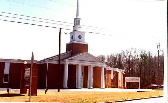
No Photo
Property Record
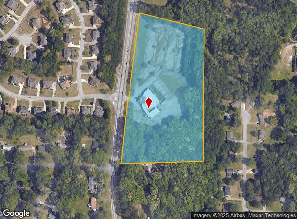
3600 Snapfinger Rd, Lithonia, GA 30038


NEARBY LISTINGS FOR SALE OR LEASE
Property Detail
3600 Snapfinger Rd
16-013-01-015
DeKalb
Religious
Georgia
X
15
13151C0040D
10.70 AC
2023
I-20 East/Conyers
2023
Atlanta
023441
Atlanta-Sandy Springs-Roswell, GA
20,699 SF
DEMOGRAPHICS near 3600 Snapfinger Rd
1 Mile
3 Mile
5 Mile
2024 Total Population
6,223
57,823
154,402
2029 Population
6,165
57,366
154,658
Pop Growth 2024-2029
(0.93%)
(0.79%)
+ 0.17%
Average Age
42
40
39
2024 Total Households
2,118
21,389
57,139
HH Growth 2024-2029
(0.94%)
(0.86%)
+ 0.13%
Median Household Inc
$73,834
$66,061
$60,937
Avg Household Size
2.90
2.70
2.60
2024 Avg HH Vehicles
2.00
2.00
2.00
Median Home Value
$235,382
$213,504
$195,146
Median Year Built
1989
1989
1989
Nearby Places
- Restaurants
- Banks
- Shops
- Fitness
- Groceries
PUBLIC TRANSPORTATION
AIRPORT
Hartsfield - Jackson Atlanta International
DRIVE
WALK
Distance
Hartsfield - Jackson Atlanta International
29 min
16.9 mi
Freight Ports
Georgia Ports - Savannah
DRIVE
WALK
Distance
Georgia Ports - Savannah
274 min
239.0 mi
SALE & LEASE HISTORY
LISTING DATE
SALE/LEASE

Sep 23, 2016
For Sale
Nearby Properties
Address
Land Use
TOTAL SIZE
Lot Size
Zoning
Address
Land Use
TOTAL SIZE
Lot Size
Zoning
317,008 SF
37.40 AC
RM100
Address
Land Use
TOTAL SIZE
Lot Size
Zoning
834,629 SF
64.50 AC
RM100
Address
Land Use
TOTAL SIZE
Lot Size
Zoning
484,198 SF
32.10 AC
RM100
Address
Land Use
TOTAL SIZE
Lot Size
Zoning
250,496 SF
14.80 AC
OI
Address
Land Use
TOTAL SIZE
Lot Size
Zoning
284,650 SF
21.80 AC
R100
Address
Land Use
TOTAL SIZE
Lot Size
Zoning
217,925 SF
23 AC
RM100
Address
Land Use
TOTAL SIZE
Lot Size
Zoning
287,681 SF
20.60 AC
RM100
Address
Land Use
TOTAL SIZE
Lot Size
Zoning
174,027 SF
35.36 AC
R100
Address
Land Use
TOTAL SIZE
Lot Size
Zoning
300,697 SF
21.10 AC
RM85
Address
Land Use
TOTAL SIZE
Lot Size
Zoning
86,140 SF
63.60 AC
R100
Address
Land Use
TOTAL SIZE
Lot Size
Zoning
249,506 SF
21 AC
RM100
Address
Land Use
TOTAL SIZE
Lot Size
Zoning
182,490 SF
12.40 AC
RM100
Address
Land Use
TOTAL SIZE
Lot Size
Zoning
144,950 SF
16.40 AC
RM100
Address
Land Use
TOTAL SIZE
Lot Size
Zoning
155,447 SF
12.10 AC
X
Address
Land Use
TOTAL SIZE
Lot Size
Zoning
168,610 SF
19.20 AC
M
Address
Land Use
TOTAL SIZE
Lot Size
Zoning
209,022 SF
16.50 AC
RM100
Address
Land Use
TOTAL SIZE
Lot Size
Zoning
253,740 SF
13.20 AC
RM75
Address
Land Use
TOTAL SIZE
Lot Size
Zoning
208,711 SF
34.30 AC
X
Address
Land Use
TOTAL SIZE
Lot Size
Zoning
198,695 SF
10.90 AC
X
Address
Land Use
TOTAL SIZE
Lot Size
Zoning
272,304 SF
25.60 AC
RM100
Address
Land Use
TOTAL SIZE
Lot Size
Zoning
138,777 SF
21.90 AC
X
Address
Land Use
TOTAL SIZE
Lot Size
Zoning
66,800 SF
10.40 AC
C1
Address
Land Use
TOTAL SIZE
Lot Size
Zoning
105,100 SF
12.10 AC
C1: LOCAL
Address
Land Use
TOTAL SIZE
Lot Size
Zoning
88,380 SF
4.90 AC
RM100
Address
Land Use
TOTAL SIZE
Lot Size
Zoning
135,539 SF
14.95 AC
X
Address
Land Use
TOTAL SIZE
Lot Size
Zoning
86,328 SF
4 AC
C1: LOCAL
Address
Land Use
TOTAL SIZE
Lot Size
Zoning
137,557 SF
11.10 AC
RM100
Address
Land Use
TOTAL SIZE
Lot Size
Zoning
66,900 SF
6.40 AC
C1
Address
Land Use
TOTAL SIZE
Lot Size
Zoning
113,030 SF
1.50 AC
X
Address
Land Use
TOTAL SIZE
Lot Size
Zoning
59,326 SF
5.90 AC
C1: LOCAL
The World's #1 Commercial Real Estate Marketplace
Connect with us
© 2025 CoStar Group
The information above has been obtained from sources believed reliable. While we do not doubt its accuracy we have not verified it and make no guarantee, warranty or representation about it. It is your responsibility to independently confirm its accuracy and completeness. Any projections, opinions, assumptions, or estimates used are for example only and do not represent the current or future performance of the property. The value of this transaction to you depends on tax and other factors which should be evaluated by your tax, financial, and legal advisors. You and your advisors should conduct a careful, independent investigation of the property to determine to your satisfaction the suitability of the property for your needs.