Property Record
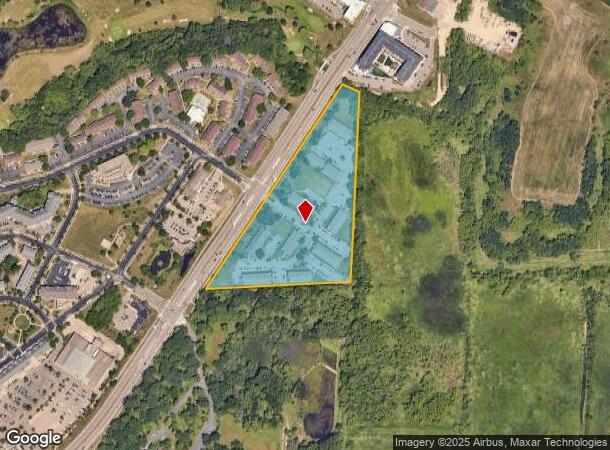
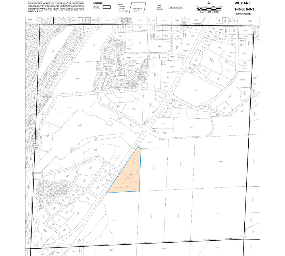
3620 Breckenridge Ct, Fitchburg, WI 53713
NEARBY LISTINGS FOR SALE OR LEASE
Property Detail
3620 Breckenridge Ct
0609-033-8300-2
SEC 3-6-9 PRT NE1/4SW1/4 COM SEC SW COR TH ALG C/L MCKEE RD N86DEG44'29E 995.41 FT TH ALG C/L FISH HATCHERY RD N33DEG35'30E 1620.27 FT TO POB TH CON ALG SD C/ L N33DEG35'30E 1445.54 FT TH S67DEG19'36E 132.41 FT TH S2DEG10'24W 1110.5 FT TH S87DEG10'34
Commercialnec
Dane
AE
Wisconsin
55025C0418G
12.03 AC
2023
Fitchburg
2023
Milwaukee/Madison
001405
Madison, WI
DEMOGRAPHICS near 3620 Breckenridge Ct
1 Mile
3 Mile
5 Mile
2024 Total Population
10,372
60,652
184,007
2029 Population
10,797
62,905
189,933
Pop Growth 2024-2029
+ 4.10%
+ 3.71%
+ 3.22%
Average Age
36
37
35
2024 Total Households
4,673
26,738
79,973
HH Growth 2024-2029
+ 4.22%
+ 3.89%
+ 3.51%
Median Household Inc
$50,346
$73,104
$64,865
Avg Household Size
2.20
2.20
2.10
2024 Avg HH Vehicles
1.00
2.00
1.00
Median Home Value
$339,513
$357,818
$356,976
Median Year Built
1992
1979
1977
Nearby Places
- Restaurants
- Banks
- Shops
- Fitness
- Groceries
PUBLIC TRANSPORTATION
AIRPORT
Dane County Regional/Truax Field
DRIVE
WALK
Distance
Dane County Regional/Truax Field
21 min
10.7 mi
Freight Ports
Port Milwaukee
DRIVE
WALK
Distance
Port Milwaukee
102 min
85.2 mi
Nearby Properties
Address
Land Use
TOTAL SIZE
Lot Size
Zoning
Address
Land Use
TOTAL SIZE
Lot Size
Zoning
2.92 AC
Address
Land Use
TOTAL SIZE
Lot Size
Zoning
21.49 AC
Address
Land Use
TOTAL SIZE
Lot Size
Zoning
169,224 SF
5.49 AC
CC-T
Address
Land Use
TOTAL SIZE
Lot Size
Zoning
87.45 AC
Address
Land Use
TOTAL SIZE
Lot Size
Zoning
18.97 AC
Address
Land Use
TOTAL SIZE
Lot Size
Zoning
16.45 AC
Address
Land Use
TOTAL SIZE
Lot Size
Zoning
6.30 AC
Address
Land Use
TOTAL SIZE
Lot Size
Zoning
172,984 SF
1.59 AC
PD
Address
Land Use
TOTAL SIZE
Lot Size
Zoning
24.62 AC
Address
Land Use
TOTAL SIZE
Lot Size
Zoning
404,794 SF
4.86 AC
CC-T
Address
Land Use
TOTAL SIZE
Lot Size
Zoning
4.22 AC
Address
Land Use
TOTAL SIZE
Lot Size
Zoning
17.80 AC
Address
Land Use
TOTAL SIZE
Lot Size
Zoning
14.47 AC
Address
Land Use
TOTAL SIZE
Lot Size
Zoning
13.87 AC
Address
Land Use
TOTAL SIZE
Lot Size
Zoning
Address
Land Use
TOTAL SIZE
Lot Size
Zoning
13.98 AC
Address
Land Use
TOTAL SIZE
Lot Size
Zoning
Address
Land Use
TOTAL SIZE
Lot Size
Zoning
329,670 SF
11.12 AC
SR-V2
Address
Land Use
TOTAL SIZE
Lot Size
Zoning
4,992 SF
4.09 AC
SE
Address
Land Use
TOTAL SIZE
Lot Size
Zoning
19.21 AC
Address
Land Use
TOTAL SIZE
Lot Size
Zoning
172,637 SF
2.63 AC
PD
Address
Land Use
TOTAL SIZE
Lot Size
Zoning
Address
Land Use
TOTAL SIZE
Lot Size
Zoning
121,671 SF
3.70 AC
PD
Address
Land Use
TOTAL SIZE
Lot Size
Zoning
Address
Land Use
TOTAL SIZE
Lot Size
Zoning
Address
Land Use
TOTAL SIZE
Lot Size
Zoning
4.56 AC
B-1
Address
Land Use
TOTAL SIZE
Lot Size
Zoning
22.45 AC
Address
Land Use
TOTAL SIZE
Lot Size
Zoning
1.49 AC
Address
Land Use
TOTAL SIZE
Lot Size
Zoning
12.50 AC
The World's #1 Commercial Real Estate Marketplace
Connect with us
© 2025 CoStar Group
The information above has been obtained from sources believed reliable. While we do not doubt its accuracy we have not verified it and make no guarantee, warranty or representation about it. It is your responsibility to independently confirm its accuracy and completeness. Any projections, opinions, assumptions, or estimates used are for example only and do not represent the current or future performance of the property. The value of this transaction to you depends on tax and other factors which should be evaluated by your tax, financial, and legal advisors. You and your advisors should conduct a careful, independent investigation of the property to determine to your satisfaction the suitability of the property for your needs.