Property Record
3621 Highway 36 S, Rosenberg, TX 77471
NEARBY LISTINGS FOR SALE OR LEASE
Property Detail
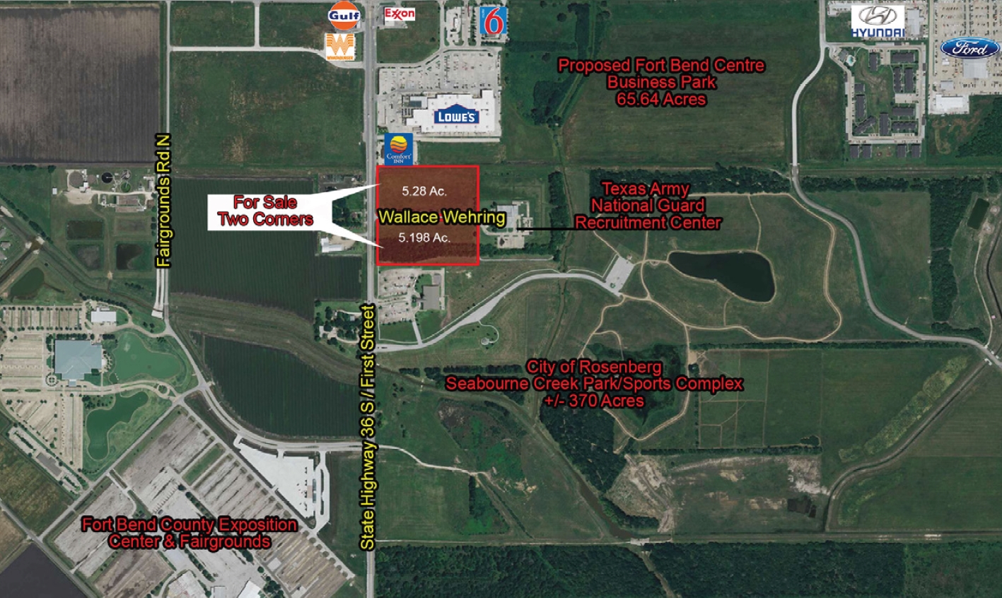
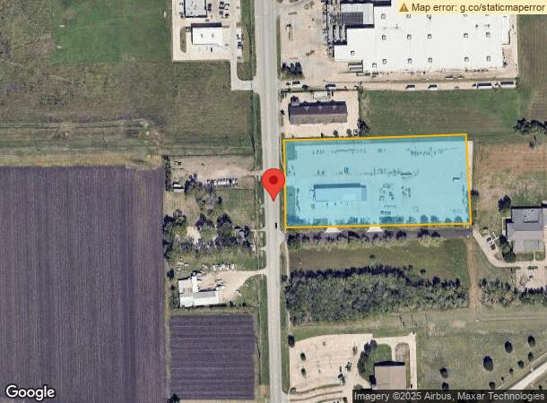
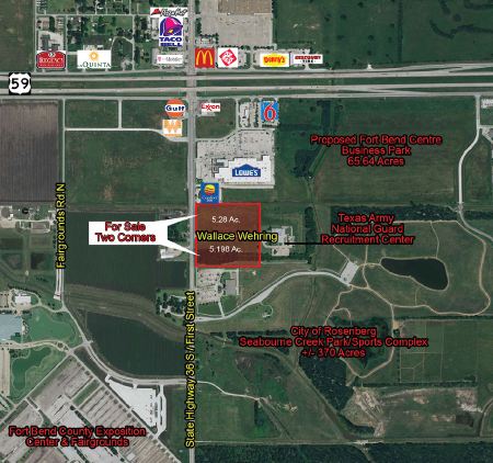
3621 Highway 36 S
Houston-The Woodlands-Sugar Land, TX
G M Stone
0312-00-000-0124-901
0312 G M STONE, ACRES 5.258, RESERVE A NATIONAL GUARD ARMORY
Commercialnec
Fort Bend
X
Texas
48157C0245L
5.26 AC
2023
Southwest Outlier
2023
Houston
675501
DEMOGRAPHICS near 3621 Highway 36 S
1 Mile
3 Mile
5 Mile
2024 Total Population
3,329
39,819
91,666
2029 Population
4,008
47,995
111,538
Pop Growth 2024-2029
+ 20.40%
+ 20.53%
+ 21.68%
Average Age
35
36
37
2024 Total Households
1,109
13,075
30,485
HH Growth 2024-2029
+ 20.92%
+ 21.10%
+ 22.31%
Median Household Inc
$63,821
$60,073
$67,971
Avg Household Size
3.00
3.00
2.90
2024 Avg HH Vehicles
2.00
2.00
2.00
Median Home Value
$217,751
$189,979
$240,973
Median Year Built
2004
1996
2006
Nearby Places
- Restaurants
- Banks
- Shops
- Fitness
- Groceries
SALE & LEASE HISTORY
LISTING DATE
SALE/LEASE

Oct 04, 2016
For Sale
Nearby Properties
Address
Land Use
TOTAL SIZE
Lot Size
Zoning
Address
Land Use
TOTAL SIZE
Lot Size
Zoning
449,167 SF
73.44 AC
IY
Address
Land Use
TOTAL SIZE
Lot Size
Zoning
672,112 SF
81.76 AC
YHN
Address
Land Use
TOTAL SIZE
Lot Size
Zoning
283,393 SF
93.42 AC
Address
Land Use
TOTAL SIZE
Lot Size
Zoning
42.10 AC
YOSN
Address
Land Use
TOTAL SIZE
Lot Size
Zoning
11.40 AC
Address
Land Use
TOTAL SIZE
Lot Size
Zoning
54,406 SF
13.13 AC
Address
Land Use
TOTAL SIZE
Lot Size
Zoning
16.23 AC
Address
Land Use
TOTAL SIZE
Lot Size
Zoning
Address
Land Use
TOTAL SIZE
Lot Size
Zoning
20,000,000 SF
6.77 AC
Address
Land Use
TOTAL SIZE
Lot Size
Zoning
Address
Land Use
TOTAL SIZE
Lot Size
Zoning
18.86 AC
Address
Land Use
TOTAL SIZE
Lot Size
Zoning
1,216 SF
24.38 AC
YZS
Address
Land Use
TOTAL SIZE
Lot Size
Zoning
96,992 SF
14.76 AC
SM
Address
Land Use
TOTAL SIZE
Lot Size
Zoning
98,691 SF
29.37 AC
Address
Land Use
TOTAL SIZE
Lot Size
Zoning
145,000 SF
17.36 AC
YSNM
Address
Land Use
TOTAL SIZE
Lot Size
Zoning
25.69 AC
Address
Land Use
TOTAL SIZE
Lot Size
Zoning
4,524 SF
13.68 AC
Address
Land Use
TOTAL SIZE
Lot Size
Zoning
37.08 AC
Address
Land Use
TOTAL SIZE
Lot Size
Zoning
54,028 SF
9.26 AC
Address
Land Use
TOTAL SIZE
Lot Size
Zoning
37,951 SF
5.39 AC
L
Address
Land Use
TOTAL SIZE
Lot Size
Zoning
85,952 SF
8.44 AC
Address
Land Use
TOTAL SIZE
Lot Size
Zoning
4.20 AC
YS
Address
Land Use
TOTAL SIZE
Lot Size
Zoning
8.01 AC
Address
Land Use
TOTAL SIZE
Lot Size
Zoning
109,852 SF
11.76 AC
S
Address
Land Use
TOTAL SIZE
Lot Size
Zoning
23,133 SF
8.93 AC
S
Address
Land Use
TOTAL SIZE
Lot Size
Zoning
133,826 SF
11.60 AC
Address
Land Use
TOTAL SIZE
Lot Size
Zoning
175,001 SF
13.19 AC
SY
Address
Land Use
TOTAL SIZE
Lot Size
Zoning
45,695 SF
3.38 AC
XY
Address
Land Use
TOTAL SIZE
Lot Size
Zoning
62,521 SF
3.05 AC
XY
Address
Land Use
TOTAL SIZE
Lot Size
Zoning
85,000 SF
19.49 AC
SN
The World's #1 Commercial Real Estate Marketplace
Connect with us
© 2025 CoStar Group
The information above has been obtained from sources believed reliable. While we do not doubt its accuracy we have not verified it and make no guarantee, warranty or representation about it. It is your responsibility to independently confirm its accuracy and completeness. Any projections, opinions, assumptions, or estimates used are for example only and do not represent the current or future performance of the property. The value of this transaction to you depends on tax and other factors which should be evaluated by your tax, financial, and legal advisors. You and your advisors should conduct a careful, independent investigation of the property to determine to your satisfaction the suitability of the property for your needs.