Property Record
3645 Latcha Rd, Millbury, OH 43447
NEARBY LISTINGS FOR SALE OR LEASE
Property Detail
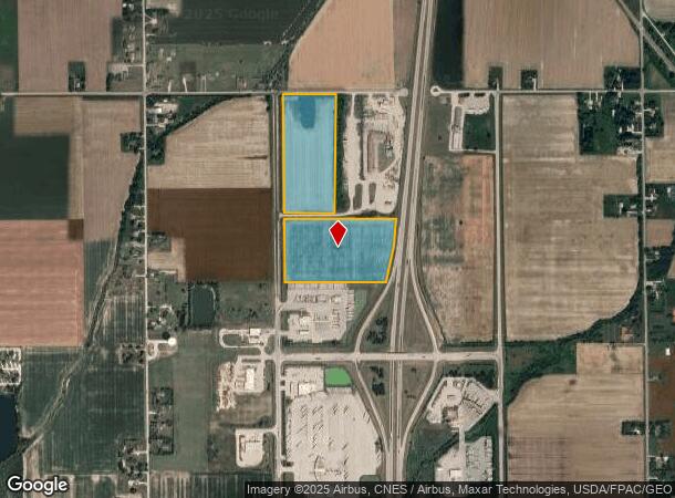
3645 Latcha Rd
Toledo, OH
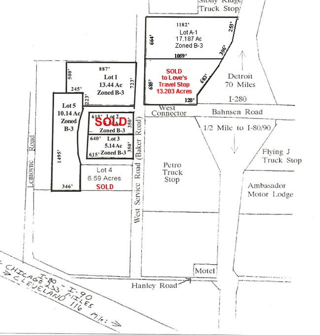
SE NW & WPT NE NW LESS S60 N1320.03 W523.75 & 13.20A PT
H28-712-270000012000
Wood
Commercialnec
Ohio
2023
32.45 AC
2024
Perrysburg/Northwood
020901
Toledo
1,088 SF
DEMOGRAPHICS near 3645 Latcha Rd
1 Mile
3 Mile
5 Mile
2024 Total Population
536
4,364
21,152
2029 Population
537
4,372
21,301
Pop Growth 2024-2029
+ 0.19%
+ 0.18%
+ 0.70%
Average Age
39
41
41
2024 Total Households
194
1,688
9,087
HH Growth 2024-2029
0.00%
+ 0.18%
+ 0.74%
Median Household Inc
$77,083
$68,376
$61,856
Avg Household Size
2.60
2.50
2.30
2024 Avg HH Vehicles
2.00
2.00
2.00
Median Home Value
$218,539
$201,257
$160,029
Median Year Built
1978
1975
1980
Nearby Places
Map Layers
Map Styles
 Street
 Aerial
- Restaurants
- Banks
- Shops
- Fitness
- Groceries
PUBLIC TRANSPORTATION
AIRPORT
Eugene F Kranz Toledo Express
DRIVE
WALK
Distance
Eugene F Kranz Toledo Express
41 min
26.8 mi
Freight Ports
Port of Toledo
DRIVE
WALK
Distance
Port of Toledo
23 min
12.3 mi
SALE & LEASE HISTORY
LISTING DATE
SALE/LEASE

Sep 24, 2016
For Sale
Nearby Properties
Address
Land Use
TOTAL SIZE
Lot Size
Zoning
Address
Land Use
TOTAL SIZE
Lot Size
Zoning
226,469 SF
17.38 AC
Address
Land Use
TOTAL SIZE
Lot Size
Zoning
3.37 AC
Address
Land Use
TOTAL SIZE
Lot Size
Zoning
40,214 SF
43.55 AC
Address
Land Use
TOTAL SIZE
Lot Size
Zoning
32,979 SF
30 AC
Address
Land Use
TOTAL SIZE
Lot Size
Zoning
89,900 SF
14.37 AC
Address
Land Use
TOTAL SIZE
Lot Size
Zoning
23,159 SF
64.66 AC
Address
Land Use
TOTAL SIZE
Lot Size
Zoning
68,338 SF
47.23 AC
Address
Land Use
TOTAL SIZE
Lot Size
Zoning
2,048 SF
122.19 AC
Address
Land Use
TOTAL SIZE
Lot Size
Zoning
56,934 SF
15.92 AC
Address
Land Use
TOTAL SIZE
Lot Size
Zoning
15,800 SF
13.20 AC
Address
Land Use
TOTAL SIZE
Lot Size
Zoning
49,538 SF
9.01 AC
Address
Land Use
TOTAL SIZE
Lot Size
Zoning
86,258 SF
31.13 AC
Address
Land Use
TOTAL SIZE
Lot Size
Zoning
29,880 SF
3.31 AC
Address
Land Use
TOTAL SIZE
Lot Size
Zoning
9,600 SF
19.30 AC
Address
Land Use
TOTAL SIZE
Lot Size
Zoning
3,750 SF
307.21 AC
Address
Land Use
TOTAL SIZE
Lot Size
Zoning
97,960 SF
8.70 AC
Address
Land Use
TOTAL SIZE
Lot Size
Zoning
17,280 SF
4.94 AC
Address
Land Use
TOTAL SIZE
Lot Size
Zoning
26,070 SF
0.21 AC
Address
Land Use
TOTAL SIZE
Lot Size
Zoning
29,413 SF
8.88 AC
Address
Land Use
TOTAL SIZE
Lot Size
Zoning
11,072 SF
19.13 AC
Address
Land Use
TOTAL SIZE
Lot Size
Zoning
29,820 SF
3.32 AC
Address
Land Use
TOTAL SIZE
Lot Size
Zoning
5.77 AC
Address
Land Use
TOTAL SIZE
Lot Size
Zoning
26,300 SF
1.15 AC
Address
Land Use
TOTAL SIZE
Lot Size
Zoning
14,544 SF
21.87 AC
Address
Land Use
TOTAL SIZE
Lot Size
Zoning
9,155 SF
0.47 AC
Address
Land Use
TOTAL SIZE
Lot Size
Zoning
18,350 SF
9.79 AC
Address
Land Use
TOTAL SIZE
Lot Size
Zoning
21,564 SF
4.37 AC
Address
Land Use
TOTAL SIZE
Lot Size
Zoning
14,620 SF
6.19 AC
Address
Land Use
TOTAL SIZE
Lot Size
Zoning
6,868 SF
4.18 AC
Address
Land Use
TOTAL SIZE
Lot Size
Zoning
28,800 SF
3 AC
The World's #1 Commercial Real Estate Marketplace
Connect with us
© 2026 CoStar Group
The information above has been obtained from sources believed reliable. While we do not doubt its accuracy we have not verified it and make no guarantee, warranty or representation about it. It is your responsibility to independently confirm its accuracy and completeness. Any projections, opinions, assumptions, or estimates used are for example only and do not represent the current or future performance of the property. The value of this transaction to you depends on tax and other factors which should be evaluated by your tax, financial, and legal advisors. You and your advisors should conduct a careful, independent investigation of the property to determine to your satisfaction the suitability of the property for your needs.