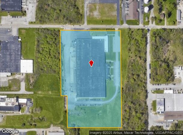
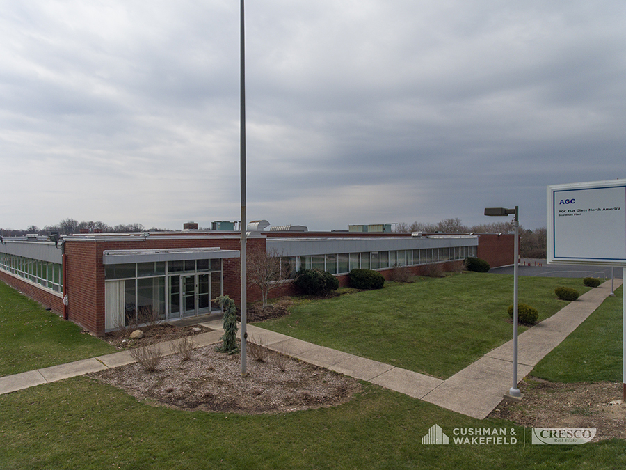
Property Record
365 Mcclurg Rd, Youngstown, OH 44512


Current Lease Availabilities
NEARBY LISTINGS FOR SALE OR LEASE
Property Detail
365 Mcclurg Rd
Youngstown/Warren/Boardman
Poma Investments Plat No 1
Youngstown-Warren-Boardman, OH-PA
LOT 3 595 X 956.62 IRR POMA INVESTMENTS PLAT NO 1
29-038-0-005.00-0
Mahoning
Warehouse
Ohio
2023
3
2023
12.65 AC
811902
Mahoning County
174,915 SF
DEMOGRAPHICS near 365 Mcclurg Rd
1 Mile
3 Mile
5 Mile
2024 Total Population
2,434
25,600
77,570
2029 Population
2,381
24,963
75,826
Pop Growth 2024-2029
(2.18%)
(2.49%)
(2.25%)
Average Age
48
46
44
2024 Total Households
1,172
11,420
33,992
HH Growth 2024-2029
(2.30%)
(2.55%)
(2.31%)
Median Household Inc
$44,158
$69,021
$60,741
Avg Household Size
2.00
2.20
2.20
2024 Avg HH Vehicles
2.00
2.00
2.00
Median Home Value
$161,671
$182,526
$160,653
Median Year Built
1980
1973
1965
Nearby Places
- Restaurants
- Banks
- Shops
- Fitness
- Groceries
Nearby Properties
Address
Land Use
TOTAL SIZE
Lot Size
Zoning
Address
Land Use
TOTAL SIZE
Lot Size
Zoning
471,532 SF
22.26 AC
C
Address
Land Use
TOTAL SIZE
Lot Size
Zoning
436,596 SF
64.24 AC
C
Address
Land Use
TOTAL SIZE
Lot Size
Zoning
318,339 SF
14.66 AC
R1
Address
Land Use
TOTAL SIZE
Lot Size
Zoning
88,156 SF
4.47 AC
C
Address
Land Use
TOTAL SIZE
Lot Size
Zoning
114,056 SF
60.31 AC
GC
Address
Land Use
TOTAL SIZE
Lot Size
Zoning
140,889 SF
14.71 AC
C
Address
Land Use
TOTAL SIZE
Lot Size
Zoning
105,326 SF
6.75 AC
Address
Land Use
TOTAL SIZE
Lot Size
Zoning
71,619 SF
12.76 AC
C
Address
Land Use
TOTAL SIZE
Lot Size
Zoning
41,443 SF
0.93 AC
C
Address
Land Use
TOTAL SIZE
Lot Size
Zoning
134,650 SF
16.10 AC
C
Address
Land Use
TOTAL SIZE
Lot Size
Zoning
57,178 SF
20.42 AC
R2
Address
Land Use
TOTAL SIZE
Lot Size
Zoning
123,712 SF
16.55 AC
MFR
Address
Land Use
TOTAL SIZE
Lot Size
Zoning
96,005 SF
3.89 AC
C
Address
Land Use
TOTAL SIZE
Lot Size
Zoning
108,150 SF
6.06 AC
C
Address
Land Use
TOTAL SIZE
Lot Size
Zoning
41,835 SF
7.46 AC
I
Address
Land Use
TOTAL SIZE
Lot Size
Zoning
83,357 SF
6.96 AC
MFR
Address
Land Use
TOTAL SIZE
Lot Size
Zoning
53,530 SF
5.85 AC
Address
Land Use
TOTAL SIZE
Lot Size
Zoning
Address
Land Use
TOTAL SIZE
Lot Size
Zoning
23,583 SF
9.76 AC
C
Address
Land Use
TOTAL SIZE
Lot Size
Zoning
39,370 SF
10.58 AC
C
Address
Land Use
TOTAL SIZE
Lot Size
Zoning
92,063 SF
13.03 AC
GC
Address
Land Use
TOTAL SIZE
Lot Size
Zoning
141,528 SF
16.11 AC
C
Address
Land Use
TOTAL SIZE
Lot Size
Zoning
140,132 SF
8.91 AC
C
Address
Land Use
TOTAL SIZE
Lot Size
Zoning
123,138 SF
8.16 AC
C
Address
Land Use
TOTAL SIZE
Lot Size
Zoning
29,735 SF
8.65 AC
C
Address
Land Use
TOTAL SIZE
Lot Size
Zoning
51,967 SF
10.60 AC
C
Address
Land Use
TOTAL SIZE
Lot Size
Zoning
102,699 SF
39.18 AC
R1
Address
Land Use
TOTAL SIZE
Lot Size
Zoning
61,506 SF
9.51 AC
C
Address
Land Use
TOTAL SIZE
Lot Size
Zoning
24,360 SF
5.84 AC
C
Address
Land Use
TOTAL SIZE
Lot Size
Zoning
73,489 SF
14.40 AC
The World's #1 Commercial Real Estate Marketplace
Connect with us
© 2025 CoStar Group
The information above has been obtained from sources believed reliable. While we do not doubt its accuracy we have not verified it and make no guarantee, warranty or representation about it. It is your responsibility to independently confirm its accuracy and completeness. Any projections, opinions, assumptions, or estimates used are for example only and do not represent the current or future performance of the property. The value of this transaction to you depends on tax and other factors which should be evaluated by your tax, financial, and legal advisors. You and your advisors should conduct a careful, independent investigation of the property to determine to your satisfaction the suitability of the property for your needs.