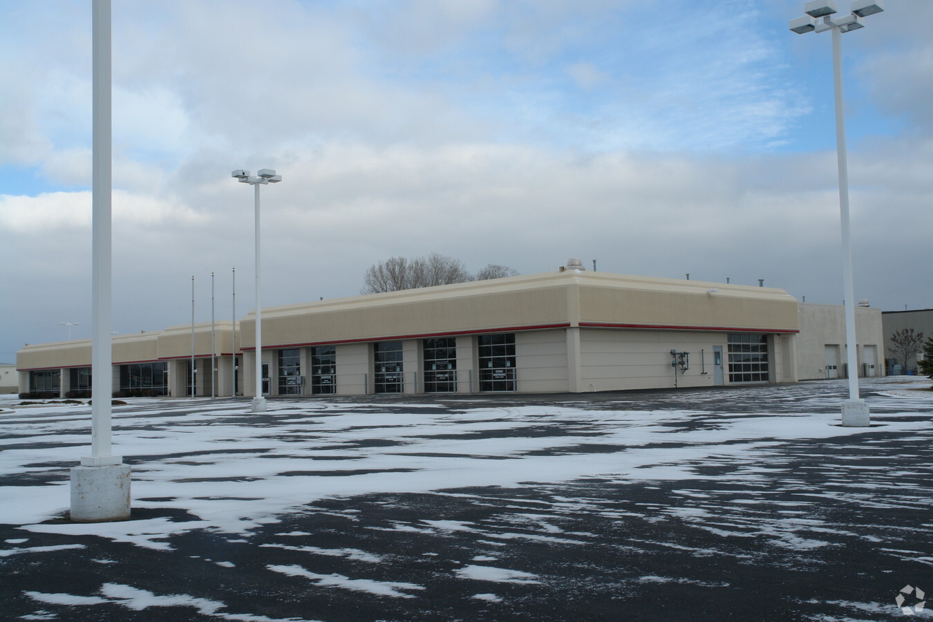
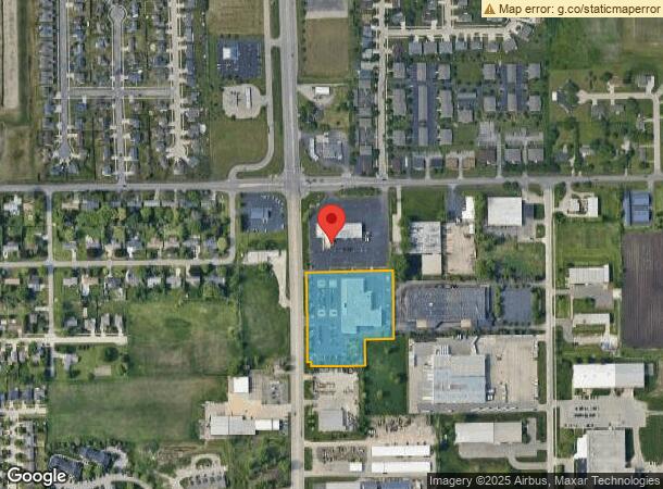
Property Record
3650 Jackson St, Oshkosh, WI 54901

NEARBY LISTINGS FOR SALE OR LEASE
Property Detail
3650 Jackson St
Oshkosh-Neenah, WI
Certified Surv Map #6255
15-19605900
LOT 2 CSM 6255 DOC #1478000 R OF D
Commercialnec
Winnebago
X
Wisconsin
55139C0225E
2
2023
4.56 AC
2023
Appleton/Oshkosh
001600
Other Market Areas
34,393 SF
DEMOGRAPHICS near 3650 Jackson St
1 Mile
3 Mile
5 Mile
2024 Total Population
4,712
31,382
69,253
2029 Population
4,662
31,288
69,517
Pop Growth 2024-2029
(1.06%)
(0.30%)
+ 0.38%
Average Age
41
37
39
2024 Total Households
1,067
11,291
28,765
HH Growth 2024-2029
+ 0.28%
+ 0.04%
+ 0.64%
Median Household Inc
$71,108
$58,948
$58,246
Avg Household Size
2.40
2.20
2.10
2024 Avg HH Vehicles
2.00
2.00
2.00
Median Home Value
$186,739
$165,491
$168,706
Median Year Built
1990
1964
1970
Nearby Places
- Restaurants
- Banks
- Shops
- Fitness
- Groceries
PUBLIC TRANSPORTATION
AIRPORT
Appleton International
DRIVE
WALK
Distance
Appleton International
24 min
17.2 mi
Freight Ports
Port Milwaukee
DRIVE
WALK
Distance
Port Milwaukee
111 min
93.1 mi
Nearby Properties
Address
Land Use
TOTAL SIZE
Lot Size
Zoning
Address
Land Use
TOTAL SIZE
Lot Size
Zoning
32.81 AC
CBPPD
Address
Land Use
TOTAL SIZE
Lot Size
Zoning
552,602 SF
7.28 AC
M3
Address
Land Use
TOTAL SIZE
Lot Size
Zoning
140,184 SF
17.35 AC
MR-20-PD
Address
Land Use
TOTAL SIZE
Lot Size
Zoning
2.40 AC
CBP-PD
Address
Land Use
TOTAL SIZE
Lot Size
Zoning
70,335 SF
16 AC
HI
Address
Land Use
TOTAL SIZE
Lot Size
Zoning
152,505 SF
6.54 AC
MR-20-RFO
Address
Land Use
TOTAL SIZE
Lot Size
Zoning
84,363 SF
10.97 AC
C-2PD
Address
Land Use
TOTAL SIZE
Lot Size
Zoning
4.52 AC
SMU-PD
Address
Land Use
TOTAL SIZE
Lot Size
Zoning
96,928 SF
6.94 AC
MR-12
Address
Land Use
TOTAL SIZE
Lot Size
Zoning
37.96 AC
Address
Land Use
TOTAL SIZE
Lot Size
Zoning
179,700 SF
10.06 AC
M3
Address
Land Use
TOTAL SIZE
Lot Size
Zoning
46,658 SF
3.32 AC
C-1
Address
Land Use
TOTAL SIZE
Lot Size
Zoning
135,562 SF
9.40 AC
MR-20-PD
Address
Land Use
TOTAL SIZE
Lot Size
Zoning
76,815 SF
12.27 AC
C2
Address
Land Use
TOTAL SIZE
Lot Size
Zoning
71,610 SF
4.30 AC
MR-20
Address
Land Use
TOTAL SIZE
Lot Size
Zoning
621,225 SF
31.97 AC
M2
Address
Land Use
TOTAL SIZE
Lot Size
Zoning
1.63 AC
SR2
Address
Land Use
TOTAL SIZE
Lot Size
Zoning
62,266 SF
14.54 AC
HI
Address
Land Use
TOTAL SIZE
Lot Size
Zoning
24,751 SF
7.75 AC
C2
Address
Land Use
TOTAL SIZE
Lot Size
Zoning
18,727 SF
2.99 AC
C1
Address
Land Use
TOTAL SIZE
Lot Size
Zoning
28,295 SF
1.77 AC
C1
Address
Land Use
TOTAL SIZE
Lot Size
Zoning
14.92 AC
M1
Address
Land Use
TOTAL SIZE
Lot Size
Zoning
21.21 AC
B3
Address
Land Use
TOTAL SIZE
Lot Size
Zoning
60,908 SF
3.92 AC
UMU
Address
Land Use
TOTAL SIZE
Lot Size
Zoning
107,400 SF
10.50 AC
M2
Address
Land Use
TOTAL SIZE
Lot Size
Zoning
60,528 SF
5.12 AC
MR-20-PD
Address
Land Use
TOTAL SIZE
Lot Size
Zoning
58,800 SF
9.56 AC
M3
Address
Land Use
TOTAL SIZE
Lot Size
Zoning
1,440 SF
0.10 AC
I2
Address
Land Use
TOTAL SIZE
Lot Size
Zoning
59,140 SF
6.08 AC
MR-20-PD
The World's #1 Commercial Real Estate Marketplace
Connect with us
© 2025 CoStar Group
The information above has been obtained from sources believed reliable. While we do not doubt its accuracy we have not verified it and make no guarantee, warranty or representation about it. It is your responsibility to independently confirm its accuracy and completeness. Any projections, opinions, assumptions, or estimates used are for example only and do not represent the current or future performance of the property. The value of this transaction to you depends on tax and other factors which should be evaluated by your tax, financial, and legal advisors. You and your advisors should conduct a careful, independent investigation of the property to determine to your satisfaction the suitability of the property for your needs.