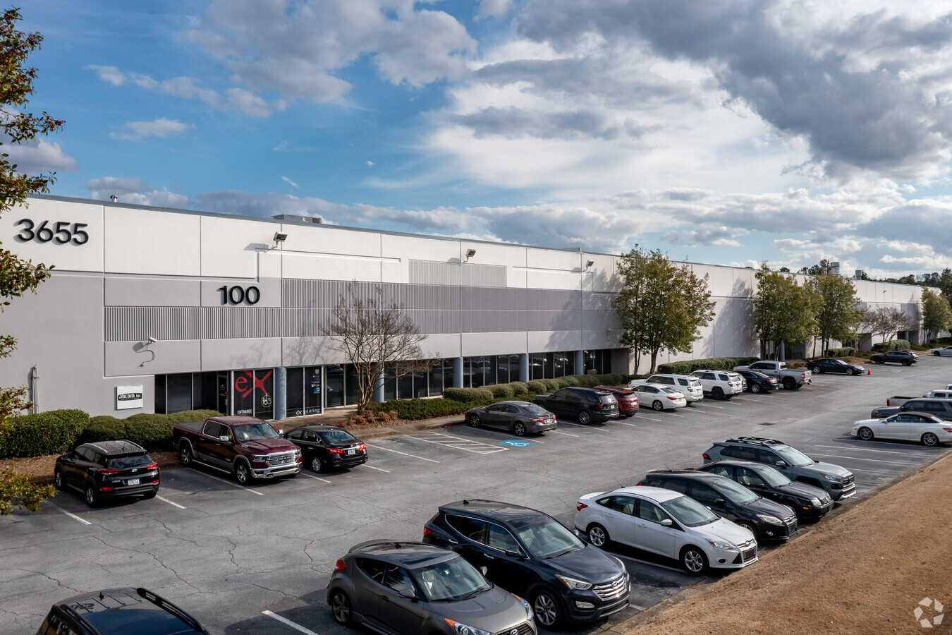
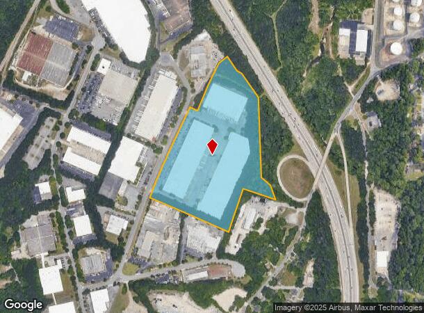
Property Record
3655 Atlanta Industrial Dr Nw, Atlanta, GA 30331


NEARBY LISTINGS FOR SALE OR LEASE
Property Detail
3655 Atlanta Industrial Dr Nw
17-0262-LL-069-3
TRANSWEST ASSOCIATES FLD CK 12/28/22; PERMIT WORK COMPL UPDATE ADDRESS 3 WHSE MULTI-TENANT COMPLEX
Warehouse
Fulton
X
Georgia
13121C0236F
23.48 AC
2023
Fulton District
2023
Atlanta
008602
Atlanta-Sandy Springs-Roswell, GA
420,810 SF
DEMOGRAPHICS near 3655 Atlanta Industrial Dr Nw
1 Mile
3 Mile
5 Mile
2024 Total Population
2,761
60,647
197,004
2029 Population
2,891
62,980
204,368
Pop Growth 2024-2029
+ 4.71%
+ 3.85%
+ 3.74%
Average Age
36
37
38
2024 Total Households
1,150
25,405
83,353
HH Growth 2024-2029
+ 4.78%
+ 3.81%
+ 3.83%
Median Household Inc
$80,038
$77,999
$74,439
Avg Household Size
2.40
2.30
2.30
2024 Avg HH Vehicles
2.00
1.00
2.00
Median Home Value
$316,827
$346,353
$358,285
Median Year Built
2003
1997
1988
Nearby Places
- Restaurants
- Banks
- Shops
- Fitness
- Groceries
PUBLIC TRANSPORTATION
AIRPORT
Hartsfield - Jackson Atlanta International
DRIVE
WALK
Distance
Hartsfield - Jackson Atlanta International
29 min
17.7 mi
Freight Ports
Georgia Ports - Savannah
DRIVE
WALK
Distance
Georgia Ports - Savannah
292 min
257.0 mi
SALE & LEASE HISTORY
LISTING DATE
SALE/LEASE

Oct 03, 2020
For Lease
Nearby Properties
Address
Land Use
TOTAL SIZE
Lot Size
Zoning
Address
Land Use
TOTAL SIZE
Lot Size
Zoning
695,481 SF
11.66 AC
RG3
Address
Land Use
TOTAL SIZE
Lot Size
Zoning
173,430 SF
13.83 AC
PVC
Address
Land Use
TOTAL SIZE
Lot Size
Zoning
329,385 SF
15.29 AC
RHR
Address
Land Use
TOTAL SIZE
Lot Size
Zoning
1,151,446 SF
I2
Address
Land Use
TOTAL SIZE
Lot Size
Zoning
439,167 SF
41.13 AC
RM-12
Address
Land Use
TOTAL SIZE
Lot Size
Zoning
Address
Land Use
TOTAL SIZE
Lot Size
Zoning
467,671 SF
4.82 AC
C1
Address
Land Use
TOTAL SIZE
Lot Size
Zoning
115 AC
I2
Address
Land Use
TOTAL SIZE
Lot Size
Zoning
499,198 SF
9.49 AC
RG3
Address
Land Use
TOTAL SIZE
Lot Size
Zoning
263,676 SF
15.70 AC
RM-12
Address
Land Use
TOTAL SIZE
Lot Size
Zoning
403,687 SF
42.37 AC
RM-12
Address
Land Use
TOTAL SIZE
Lot Size
Zoning
3.25 AC
MU
Address
Land Use
TOTAL SIZE
Lot Size
Zoning
354,710 SF
22.86 AC
R5
Address
Land Use
TOTAL SIZE
Lot Size
Zoning
281,632 SF
27.12 AC
RM-12
Address
Land Use
TOTAL SIZE
Lot Size
Zoning
307,837 SF
3.43 AC
PVC
Address
Land Use
TOTAL SIZE
Lot Size
Zoning
285.03 AC
I2
Address
Land Use
TOTAL SIZE
Lot Size
Zoning
694,436 SF
36.80 AC
HI
Address
Land Use
TOTAL SIZE
Lot Size
Zoning
553,853 SF
3.70 AC
RG4
Address
Land Use
TOTAL SIZE
Lot Size
Zoning
251,706 SF
20.22 AC
RM-12
Address
Land Use
TOTAL SIZE
Lot Size
Zoning
68.38 AC
R2
Address
Land Use
TOTAL SIZE
Lot Size
Zoning
190,008 SF
6.97 AC
RG3
Address
Land Use
TOTAL SIZE
Lot Size
Zoning
70,908 SF
9.77 AC
RG3
Address
Land Use
TOTAL SIZE
Lot Size
Zoning
235,602 SF
17.53 AC
RG3
Address
Land Use
TOTAL SIZE
Lot Size
Zoning
211,506 SF
20.63 AC
CRC
Address
Land Use
TOTAL SIZE
Lot Size
Zoning
77.56 AC
RG3
Address
Land Use
TOTAL SIZE
Lot Size
Zoning
191,400 SF
25.70 AC
LI
Address
Land Use
TOTAL SIZE
Lot Size
Zoning
175,630 SF
5.06 AC
RM-12
Address
Land Use
TOTAL SIZE
Lot Size
Zoning
202,430 SF
7.31 AC
C1
Address
Land Use
TOTAL SIZE
Lot Size
Zoning
167,201 SF
7.32 AC
C1
Address
Land Use
TOTAL SIZE
Lot Size
Zoning
85,461 SF
10.62 AC
RG3
The World's #1 Commercial Real Estate Marketplace
Connect with us
© 2025 CoStar Group
The information above has been obtained from sources believed reliable. While we do not doubt its accuracy we have not verified it and make no guarantee, warranty or representation about it. It is your responsibility to independently confirm its accuracy and completeness. Any projections, opinions, assumptions, or estimates used are for example only and do not represent the current or future performance of the property. The value of this transaction to you depends on tax and other factors which should be evaluated by your tax, financial, and legal advisors. You and your advisors should conduct a careful, independent investigation of the property to determine to your satisfaction the suitability of the property for your needs.