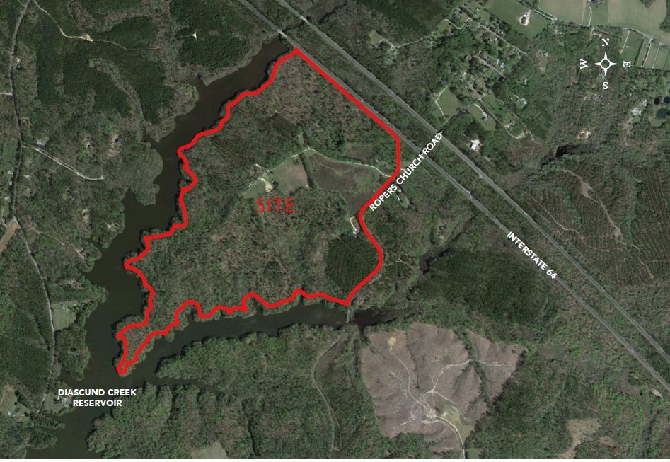
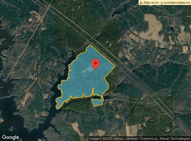
Property Record
3700 Ropers Church Rd, Lanexa, VA 23089
NEARBY LISTINGS FOR SALE OR LEASE
Property Detail
3700 Ropers Church Rd
46 4
PLEASANT VIEW DB 46/79 274 AC PB 1/65
Municipalproperty
New Kent
A
Virginia
51127C0250D
4
0
274 AC
2024
New Kent County
700301
Richmond VA
2,444 SF
Richmond, VA
DEMOGRAPHICS near 3700 Ropers Church Rd
1 Mile
3 Mile
5 Mile
2024 Total Population
283
3,155
11,119
2029 Population
340
3,622
12,764
Pop Growth 2024-2029
+ 20.14%
+ 14.80%
+ 14.79%
Average Age
43
42
43
2024 Total Households
91
1,120
3,994
HH Growth 2024-2029
+ 19.78%
+ 14.55%
+ 14.77%
Median Household Inc
$103,125
$89,883
$96,226
Avg Household Size
2.50
2.60
2.60
2024 Avg HH Vehicles
3.00
3.00
3.00
Median Home Value
$357,499
$380,099
$397,699
Median Year Built
1988
1990
1997
Nearby Places
- Restaurants
- Banks
- Shops
- Fitness
- Groceries
PUBLIC TRANSPORTATION
AIRPORT
Richmond International
DRIVE
WALK
Distance
Richmond International
42 min
31.2 mi
Freight Ports
Virginia Port Authority - Richmond
DRIVE
WALK
Distance
Virginia Port Authority - Richmond
56 min
40.4 mi
SALE & LEASE HISTORY
LISTING DATE
SALE/LEASE

Mar 25, 2019
For Sale
Nearby Properties
Address
Land Use
TOTAL SIZE
Lot Size
Zoning
Address
Land Use
TOTAL SIZE
Lot Size
Zoning
6,700 SF
1,791.02 AC
A1
Address
Land Use
TOTAL SIZE
Lot Size
Zoning
2,226 SF
18.27 AC
A1
Address
Land Use
TOTAL SIZE
Lot Size
Zoning
307.78 AC
A1
Address
Land Use
TOTAL SIZE
Lot Size
Zoning
1,196 SF
16.85 AC
IND
Address
Land Use
TOTAL SIZE
Lot Size
Zoning
363.63 AC
A1
Address
Land Use
TOTAL SIZE
Lot Size
Zoning
27,414 SF
162.30 AC
A1 GENERAL
Address
Land Use
TOTAL SIZE
Lot Size
Zoning
266.21 AC
A1
Address
Land Use
TOTAL SIZE
Lot Size
Zoning
318 AC
PUD
Address
Land Use
TOTAL SIZE
Lot Size
Zoning
266.86 AC
A1
Address
Land Use
TOTAL SIZE
Lot Size
Zoning
1,344 SF
188.68 AC
A1 GENERAL
Address
Land Use
TOTAL SIZE
Lot Size
Zoning
254 AC
A1
Address
Land Use
TOTAL SIZE
Lot Size
Zoning
176.80 AC
A1
Address
Land Use
TOTAL SIZE
Lot Size
Zoning
212 AC
A1
Address
Land Use
TOTAL SIZE
Lot Size
Zoning
2,744 SF
138 AC
A1 GENERAL
Address
Land Use
TOTAL SIZE
Lot Size
Zoning
208.48 AC
A1
Address
Land Use
TOTAL SIZE
Lot Size
Zoning
7.46 AC
EO
Address
Land Use
TOTAL SIZE
Lot Size
Zoning
19,234 SF
22.15 AC
A1 GENERAL
Address
Land Use
TOTAL SIZE
Lot Size
Zoning
210 SF
196.30 AC
A1 GENERAL
Address
Land Use
TOTAL SIZE
Lot Size
Zoning
84 AC
EO
Address
Land Use
TOTAL SIZE
Lot Size
Zoning
1,200 SF
97.50 AC
A1 GENERAL
Address
Land Use
TOTAL SIZE
Lot Size
Zoning
10.44 AC
EO
Address
Land Use
TOTAL SIZE
Lot Size
Zoning
1.20 AC
A1
Address
Land Use
TOTAL SIZE
Lot Size
Zoning
215.77 AC
A1 GENERAL
Address
Land Use
TOTAL SIZE
Lot Size
Zoning
2,132 SF
108.47 AC
A1 GENERAL
Address
Land Use
TOTAL SIZE
Lot Size
Zoning
3,453 SF
26.04 AC
A1 GENERAL
Address
Land Use
TOTAL SIZE
Lot Size
Zoning
52.82 AC
B1 GENERAL
Address
Land Use
TOTAL SIZE
Lot Size
Zoning
52.82 AC
B1 GENERAL
Address
Land Use
TOTAL SIZE
Lot Size
Zoning
133.85 AC
A1
Address
Land Use
TOTAL SIZE
Lot Size
Zoning
142 AC
A1
The World's #1 Commercial Real Estate Marketplace
Connect with us
© 2025 CoStar Group
The information above has been obtained from sources believed reliable. While we do not doubt its accuracy we have not verified it and make no guarantee, warranty or representation about it. It is your responsibility to independently confirm its accuracy and completeness. Any projections, opinions, assumptions, or estimates used are for example only and do not represent the current or future performance of the property. The value of this transaction to you depends on tax and other factors which should be evaluated by your tax, financial, and legal advisors. You and your advisors should conduct a careful, independent investigation of the property to determine to your satisfaction the suitability of the property for your needs.