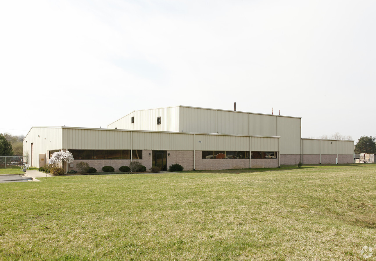
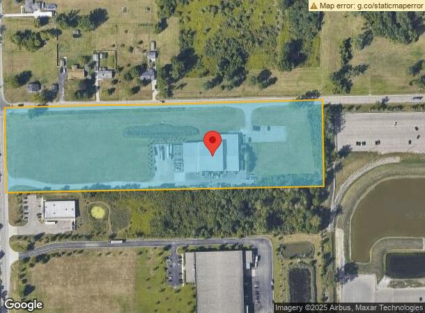
Property Record
37015 Pennsylvania Rd, New Boston, MI 48164

NEARBY LISTINGS FOR SALE OR LEASE
Property Detail
37015 Pennsylvania Rd
Detroit-Warren-Dearborn, MI
New Boston Woods Sub
75-018-99-0003-000
05J THE NORTH 356.0 FT OF THE NW 1/4 OF THE NW 1/4 OF SEC 5. 10.89 ACRES
Manufacturinglight
Wayne
X
Michigan
26163C0370F
0003
2024
9.63 AC
2024
Airport District
590500
Detroit
31,375 SF
DEMOGRAPHICS near 37015 Pennsylvania Rd
1 Mile
3 Mile
5 Mile
2024 Total Population
1,244
8,480
41,506
2029 Population
1,212
8,165
39,853
Pop Growth 2024-2029
(2.57%)
(3.71%)
(3.98%)
Average Age
45
43
41
2024 Total Households
512
3,333
16,495
HH Growth 2024-2029
(2.54%)
(3.69%)
(4.01%)
Median Household Inc
$91,666
$84,018
$71,979
Avg Household Size
2.40
2.50
2.50
2024 Avg HH Vehicles
2.00
2.00
2.00
Median Home Value
$208,784
$228,416
$217,877
Median Year Built
1984
1970
1975
Nearby Places
- Restaurants
- Banks
- Shops
- Fitness
- Groceries
PUBLIC TRANSPORTATION
AIRPORT
Detroit Metro Wayne County
DRIVE
WALK
Distance
Detroit Metro Wayne County
9 min
4.9 mi
Windsor International
DRIVE
WALK
Distance
Windsor International
55 min
33.3 mi
Freight Ports
Port of Toledo
DRIVE
WALK
Distance
Port of Toledo
58 min
44.6 mi
Nearby Properties
Address
Land Use
TOTAL SIZE
Lot Size
Zoning
Address
Land Use
TOTAL SIZE
Lot Size
Zoning
72.97 AC
Address
Land Use
TOTAL SIZE
Lot Size
Zoning
516,762 SF
51.63 AC
Address
Land Use
TOTAL SIZE
Lot Size
Zoning
Address
Land Use
TOTAL SIZE
Lot Size
Zoning
1,249,073 SF
154.21 AC
M2-GEN
Address
Land Use
TOTAL SIZE
Lot Size
Zoning
500,240 SF
55.95 AC
M2-GEN
Address
Land Use
TOTAL SIZE
Lot Size
Zoning
600,000 SF
M1-LIG
Address
Land Use
TOTAL SIZE
Lot Size
Zoning
500,240 SF
M1-LIG
Address
Land Use
TOTAL SIZE
Lot Size
Zoning
199,722 SF
30.86 AC
M2-GEN
Address
Land Use
TOTAL SIZE
Lot Size
Zoning
462,840 SF
45.66 AC
Address
Land Use
TOTAL SIZE
Lot Size
Zoning
87,000 SF
18.02 AC
Address
Land Use
TOTAL SIZE
Lot Size
Zoning
45.66 AC
Address
Land Use
TOTAL SIZE
Lot Size
Zoning
338,896 SF
14.35 AC
M2-GEN
Address
Land Use
TOTAL SIZE
Lot Size
Zoning
105,000 SF
15.26 AC
Address
Land Use
TOTAL SIZE
Lot Size
Zoning
17.20 AC
B1 LOCA
Address
Land Use
TOTAL SIZE
Lot Size
Zoning
79,895 SF
12.56 AC
M2-GEN
Address
Land Use
TOTAL SIZE
Lot Size
Zoning
Address
Land Use
TOTAL SIZE
Lot Size
Zoning
117,695 SF
21.72 AC
M2-GEN
Address
Land Use
TOTAL SIZE
Lot Size
Zoning
89,391 SF
M2-GEN
Address
Land Use
TOTAL SIZE
Lot Size
Zoning
47.09 AC
I2 HEAV
Address
Land Use
TOTAL SIZE
Lot Size
Zoning
15.26 AC
Address
Land Use
TOTAL SIZE
Lot Size
Zoning
61,100 SF
6.88 AC
M2-GEN
Address
Land Use
TOTAL SIZE
Lot Size
Zoning
M1-LIG
Address
Land Use
TOTAL SIZE
Lot Size
Zoning
Address
Land Use
TOTAL SIZE
Lot Size
Zoning
105,728 SF
18.41 AC
M2-GEN
Address
Land Use
TOTAL SIZE
Lot Size
Zoning
62,760 SF
4.25 AC
M2PDA
Address
Land Use
TOTAL SIZE
Lot Size
Zoning
106,704 SF
16.89 AC
M2-GEN
Address
Land Use
TOTAL SIZE
Lot Size
Zoning
62,650 SF
32.02 AC
M2 GEN
Address
Land Use
TOTAL SIZE
Lot Size
Zoning
88,740 SF
13.36 AC
M2-GEN
Address
Land Use
TOTAL SIZE
Lot Size
Zoning
82,615 SF
8.61 AC
M2-GEN
Address
Land Use
TOTAL SIZE
Lot Size
Zoning
76.32 AC
The World's #1 Commercial Real Estate Marketplace
Connect with us
© 2025 CoStar Group
The information above has been obtained from sources believed reliable. While we do not doubt its accuracy we have not verified it and make no guarantee, warranty or representation about it. It is your responsibility to independently confirm its accuracy and completeness. Any projections, opinions, assumptions, or estimates used are for example only and do not represent the current or future performance of the property. The value of this transaction to you depends on tax and other factors which should be evaluated by your tax, financial, and legal advisors. You and your advisors should conduct a careful, independent investigation of the property to determine to your satisfaction the suitability of the property for your needs.