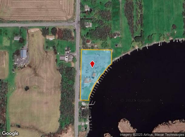
Property Record
372 Manitou Rd, Hilton, NY 14468


NEARBY LISTINGS FOR SALE OR LEASE
-
-
View all Hilton listings for sale on LoopNet.com
Property Detail
372 Manitou Rd
Rochester, NY
First Division
262800-025-010-0002-016-000
1ST DIV L60 T2
Marinafacility
Monroe
AE
New York
36055C0061H
16.000
2024
2.20 AC
2023
Northwest
013503
Rochester
2,112 SF
DEMOGRAPHICS near 372 Manitou Rd
1 Mile
3 Mile
5 Mile
2024 Total Population
698
12,455
33,643
2029 Population
686
12,156
33,058
Pop Growth 2024-2029
(1.72%)
(2.40%)
(1.74%)
Average Age
42
42
44
2024 Total Households
257
4,788
13,068
HH Growth 2024-2029
(1.95%)
(2.57%)
(1.84%)
Median Household Inc
$103,750
$87,421
$90,273
Avg Household Size
2.70
2.50
2.50
2024 Avg HH Vehicles
2.00
2.00
2.00
Median Home Value
$247,391
$191,700
$195,197
Median Year Built
1983
1976
1981
Nearby Places
- Restaurants
- Banks
- Shops
- Fitness
- Groceries
PUBLIC TRANSPORTATION
AIRPORT
Frederick Douglass/Greater Rochester International
DRIVE
WALK
Distance
Frederick Douglass/Greater Rochester International
26 min
18.7 mi
Freight Ports
Albany, NY Port
DRIVE
WALK
Distance
Albany, NY Port
290 min
244.6 mi
SALE & LEASE HISTORY
LISTING DATE
SALE/LEASE

May 24, 2021
For Sale
Nearby Properties
Address
Land Use
TOTAL SIZE
Lot Size
Zoning
Address
Land Use
TOTAL SIZE
Lot Size
Zoning
3,634 SF
84.10 AC
RA-2
Address
Land Use
TOTAL SIZE
Lot Size
Zoning
69,000 SF
243.10 AC
Address
Land Use
TOTAL SIZE
Lot Size
Zoning
1,763.70 AC
Address
Land Use
TOTAL SIZE
Lot Size
Zoning
250,000 SF
59.11 AC
02 - SINGL
Address
Land Use
TOTAL SIZE
Lot Size
Zoning
11,452 SF
13.10 AC
03 - MULTI
Address
Land Use
TOTAL SIZE
Lot Size
Zoning
30,194 SF
24 AC
02 - SINGL
Address
Land Use
TOTAL SIZE
Lot Size
Zoning
31,823 SF
2.82 AC
05 - COMME
Address
Land Use
TOTAL SIZE
Lot Size
Zoning
6,462 SF
8.20 AC
03 - MULTI
Address
Land Use
TOTAL SIZE
Lot Size
Zoning
56,669 SF
5.82 AC
05 - COMME
Address
Land Use
TOTAL SIZE
Lot Size
Zoning
4,352 SF
20.50 AC
03 - MULTI
Address
Land Use
TOTAL SIZE
Lot Size
Zoning
1.90 AC
05 - COMME
Address
Land Use
TOTAL SIZE
Lot Size
Zoning
53,613 SF
4.20 AC
05 - COMME
Address
Land Use
TOTAL SIZE
Lot Size
Zoning
16,212 SF
6.48 AC
02 - SINGL
Address
Land Use
TOTAL SIZE
Lot Size
Zoning
37,488 SF
5.50 AC
02 - SINGL
Address
Land Use
TOTAL SIZE
Lot Size
Zoning
5,906 SF
24.10 AC
Address
Land Use
TOTAL SIZE
Lot Size
Zoning
15.12 AC
Address
Land Use
TOTAL SIZE
Lot Size
Zoning
11,771 SF
110 AC
Address
Land Use
TOTAL SIZE
Lot Size
Zoning
7,336 SF
0.01 AC
05 - COMME
Address
Land Use
TOTAL SIZE
Lot Size
Zoning
14,220 SF
3.20 AC
05 - COMME
Address
Land Use
TOTAL SIZE
Lot Size
Zoning
9,288 SF
1.60 AC
03 - MULTI
Address
Land Use
TOTAL SIZE
Lot Size
Zoning
13,756 SF
1.60 AC
02 - SINGL
Address
Land Use
TOTAL SIZE
Lot Size
Zoning
9.42 AC
Address
Land Use
TOTAL SIZE
Lot Size
Zoning
20.96 AC
Address
Land Use
TOTAL SIZE
Lot Size
Zoning
9,239 SF
1 AC
05 - COMME
Address
Land Use
TOTAL SIZE
Lot Size
Zoning
5,000 SF
5.60 AC
Address
Land Use
TOTAL SIZE
Lot Size
Zoning
67.90 AC
Address
Land Use
TOTAL SIZE
Lot Size
Zoning
5,200 SF
10.04 AC
02 - SINGL
Address
Land Use
TOTAL SIZE
Lot Size
Zoning
8,064 SF
0.27 AC
05 - COMME
Address
Land Use
TOTAL SIZE
Lot Size
Zoning
237.50 AC
N00
Address
Land Use
TOTAL SIZE
Lot Size
Zoning
4,240 SF
9.02 AC
The World's #1 Commercial Real Estate Marketplace
Connect with us
© 2025 CoStar Group
The information above has been obtained from sources believed reliable. While we do not doubt its accuracy we have not verified it and make no guarantee, warranty or representation about it. It is your responsibility to independently confirm its accuracy and completeness. Any projections, opinions, assumptions, or estimates used are for example only and do not represent the current or future performance of the property. The value of this transaction to you depends on tax and other factors which should be evaluated by your tax, financial, and legal advisors. You and your advisors should conduct a careful, independent investigation of the property to determine to your satisfaction the suitability of the property for your needs.