Property Record
3743 Chilson Rd, Howell, MI 48843
This Property Is For Sale
NEARBY LISTINGS FOR SALE OR LEASE
Property Detail
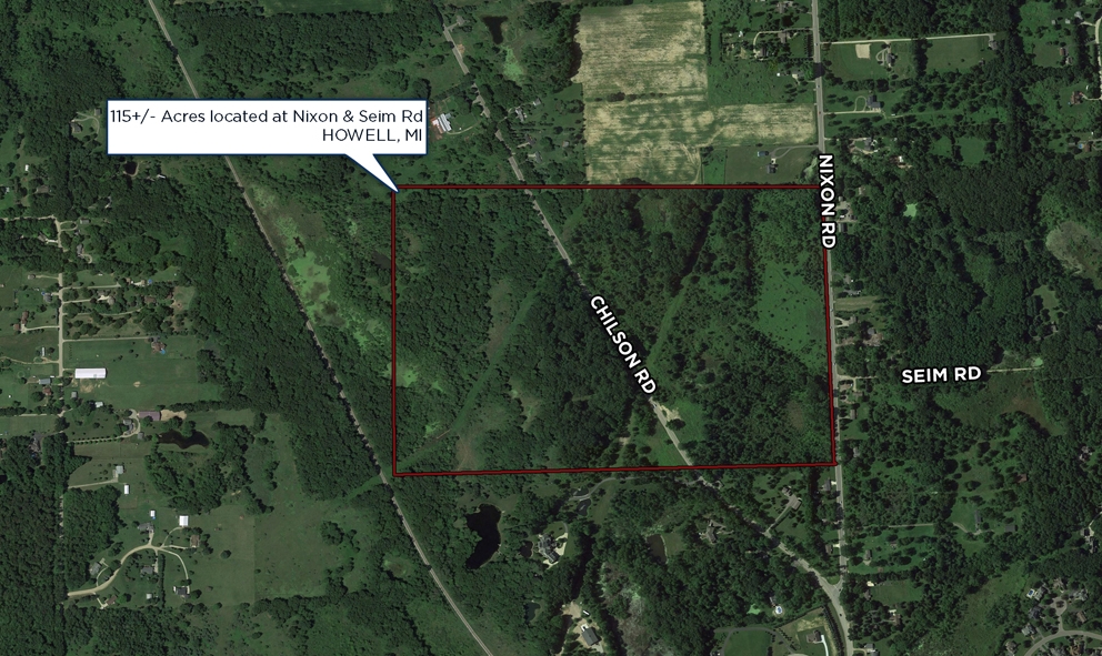
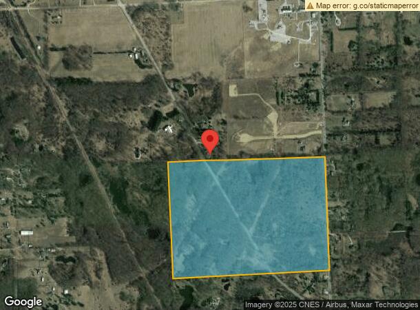
3743 Chilson Rd
11-20-400-007
SEC. 20 T2N, R5E, BEG E 1/4 COR, TH S02*14'50"E 1900 FT, TH S88*54'58"W 2629.32 FT, TH N02*25'52"W 1932.71 FT, TH N89*16'18"E
Agriculturalland
Livingston
X
Michigan
26093C0320D
115 AC
2024
Livingston County
2024
Detroit
742500
Detroit-Warren-Dearborn, MI
DEMOGRAPHICS near 3743 Chilson Rd
1 Mile
3 Mile
5 Mile
2024 Total Population
994
11,591
45,416
2029 Population
1,018
11,922
46,775
Pop Growth 2024-2029
+ 2.41%
+ 2.86%
+ 2.99%
Average Age
46
46
44
2024 Total Households
368
4,608
18,147
HH Growth 2024-2029
+ 2.17%
+ 2.84%
+ 2.99%
Median Household Inc
$97,135
$97,461
$93,427
Avg Household Size
2.70
2.50
2.50
2024 Avg HH Vehicles
2.00
2.00
2.00
Median Home Value
$373,749
$371,090
$329,652
Median Year Built
1992
1988
1991
Nearby Places
- Restaurants
- Banks
- Shops
- Fitness
- Groceries
PUBLIC TRANSPORTATION
AIRPORT
Bishop International
DRIVE
WALK
Distance
Bishop International
61 min
44.2 mi
Freight Ports
Port of Toledo
DRIVE
WALK
Distance
Port of Toledo
109 min
87.4 mi
Nearby Properties
Address
Land Use
TOTAL SIZE
Lot Size
Zoning
Address
Land Use
TOTAL SIZE
Lot Size
Zoning
1,296 SF
19.42 AC
MUPUD
Address
Land Use
TOTAL SIZE
Lot Size
Zoning
210,003 SF
29.17 AC
MUPUD
Address
Land Use
TOTAL SIZE
Lot Size
Zoning
165,868 SF
27.80 AC
HDR
Address
Land Use
TOTAL SIZE
Lot Size
Zoning
60,900 SF
5.74 AC
NRPUD
Address
Land Use
TOTAL SIZE
Lot Size
Zoning
134,688 SF
14.97 AC
NRPUD
Address
Land Use
TOTAL SIZE
Lot Size
Zoning
53,494 SF
10 AC
MUPUD
Address
Land Use
TOTAL SIZE
Lot Size
Zoning
220,091 SF
21.88 AC
NRPUD
Address
Land Use
TOTAL SIZE
Lot Size
Zoning
166,550 SF
20 AC
IND
Address
Land Use
TOTAL SIZE
Lot Size
Zoning
96,896 SF
12.11 AC
HDR
Address
Land Use
TOTAL SIZE
Lot Size
Zoning
91,380 SF
11.55 AC
HDR
Address
Land Use
TOTAL SIZE
Lot Size
Zoning
65,560 SF
2.56 AC
NRPUD
Address
Land Use
TOTAL SIZE
Lot Size
Zoning
121,265 SF
15.10 AC
RCD
Address
Land Use
TOTAL SIZE
Lot Size
Zoning
51.99 AC
MHP
Address
Land Use
TOTAL SIZE
Lot Size
Zoning
73,296 SF
7 AC
HDR
Address
Land Use
TOTAL SIZE
Lot Size
Zoning
44,100 SF
5.24 AC
MUPUD
Address
Land Use
TOTAL SIZE
Lot Size
Zoning
4,032 SF
22.33 AC
PRF
Address
Land Use
TOTAL SIZE
Lot Size
Zoning
38,831 SF
7.08 AC
NRPUD
Address
Land Use
TOTAL SIZE
Lot Size
Zoning
58,111 SF
6.21 AC
IND
Address
Land Use
TOTAL SIZE
Lot Size
Zoning
88,520 SF
9.45 AC
NRPUD
Address
Land Use
TOTAL SIZE
Lot Size
Zoning
63,071 SF
10 AC
IND
Address
Land Use
TOTAL SIZE
Lot Size
Zoning
69,866 SF
9.21 AC
GCD
Address
Land Use
TOTAL SIZE
Lot Size
Zoning
33,328 SF
5.59 AC
MUPUD
Address
Land Use
TOTAL SIZE
Lot Size
Zoning
8,130 SF
1.77 AC
NRPUD
Address
Land Use
TOTAL SIZE
Lot Size
Zoning
61,978 SF
6.24 AC
IND
Address
Land Use
TOTAL SIZE
Lot Size
Zoning
49,177 SF
5.37 AC
MUPUD
Address
Land Use
TOTAL SIZE
Lot Size
Zoning
62,080 SF
6 AC
IND
Address
Land Use
TOTAL SIZE
Lot Size
Zoning
30,000 SF
10.10 AC
IND
Address
Land Use
TOTAL SIZE
Lot Size
Zoning
20,336 SF
2.71 AC
NRPUD
Address
Land Use
TOTAL SIZE
Lot Size
Zoning
54,084 SF
7.09 AC
IND
Address
Land Use
TOTAL SIZE
Lot Size
Zoning
30,459 SF
7.26 AC
GCD
The World's #1 Commercial Real Estate Marketplace
Connect with us
© 2025 CoStar Group
The information above has been obtained from sources believed reliable. While we do not doubt its accuracy we have not verified it and make no guarantee, warranty or representation about it. It is your responsibility to independently confirm its accuracy and completeness. Any projections, opinions, assumptions, or estimates used are for example only and do not represent the current or future performance of the property. The value of this transaction to you depends on tax and other factors which should be evaluated by your tax, financial, and legal advisors. You and your advisors should conduct a careful, independent investigation of the property to determine to your satisfaction the suitability of the property for your needs.