Property Record
375 Arthur Rd, Martinez, CA 94553
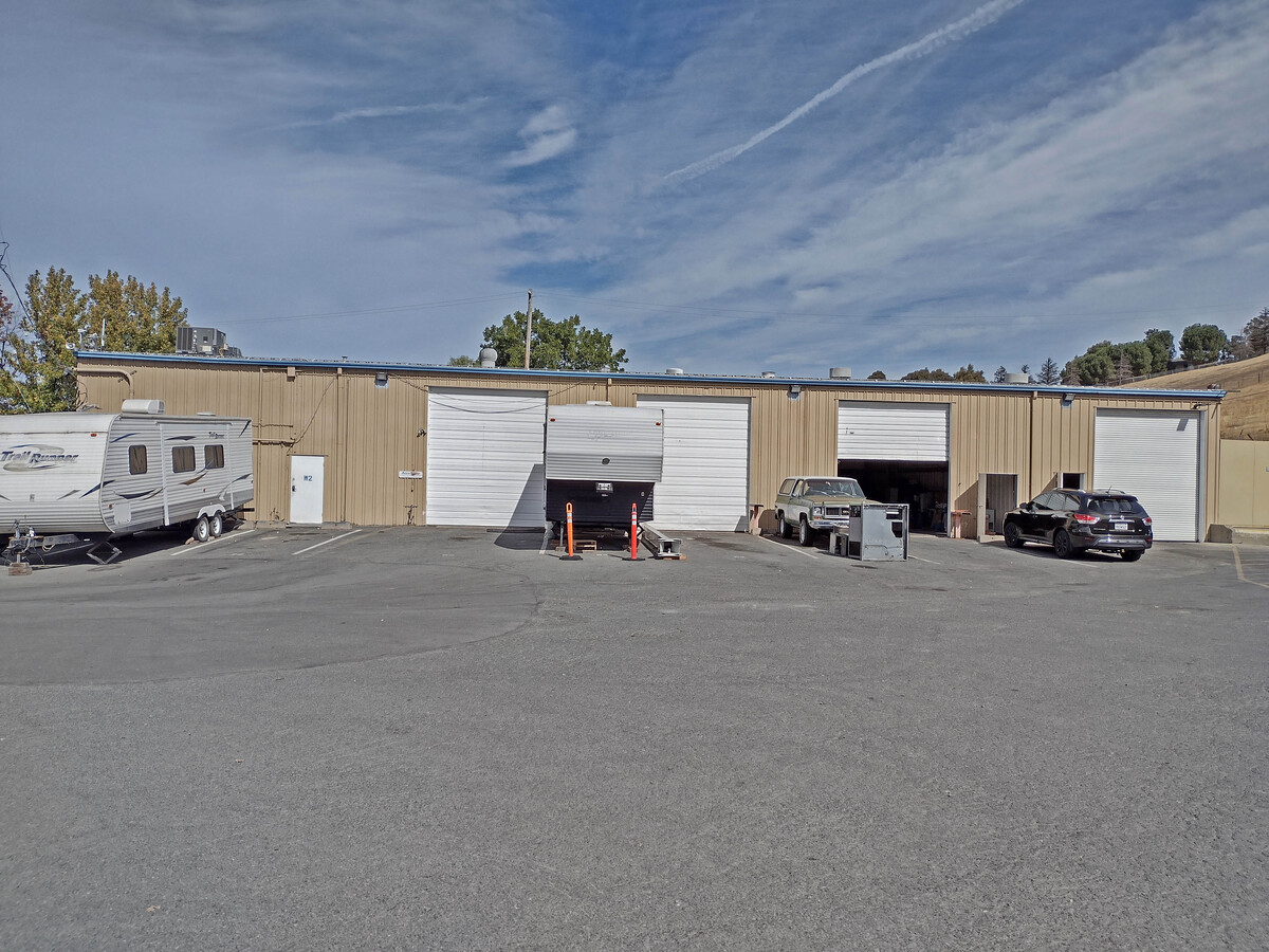
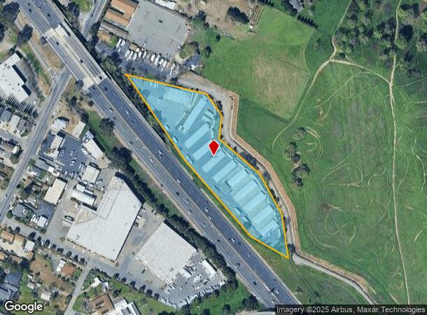

This Property Is For Sale
NEARBY LISTINGS FOR SALE OR LEASE
-
-
-
No Photo
-
-
View all Martinez listings for sale on LoopNet.com
Property Detail
375 Arthur Rd
380-043-004-7
Ro Las Juntas
Conveniencestore
RO LAS JUNTAS
X
Contra Costa
06013C0089H
California
2023
3.99 AC
2024
Martinez/Pacheco/Hercules
320001
East Bay/Oakland
35,948 SF
Oakland-Hayward-Berkeley, CA
DEMOGRAPHICS near 375 Arthur Rd
1 Mile
3 Mile
5 Mile
2024 Total Population
5,929
57,301
148,570
2029 Population
5,873
56,835
147,423
Pop Growth 2024-2029
(0.94%)
(0.81%)
(0.77%)
Average Age
40
42
41
2024 Total Households
2,043
22,370
56,530
HH Growth 2024-2029
(0.93%)
(0.84%)
(0.78%)
Median Household Inc
$123,110
$112,630
$104,626
Avg Household Size
2.80
2.50
2.50
2024 Avg HH Vehicles
2.00
2.00
2.00
Median Home Value
$721,264
$711,360
$739,153
Median Year Built
1981
1975
1971
Nearby Places
- Restaurants
- Banks
- Shops
- Fitness
- Groceries
PUBLIC TRANSPORTATION
COMMUTER RAIL
Martinez (California Zephyr - Capitol Corridor Joint Powers Authority, Capitol Corridor - Capitol Corridor Joint Powers Authority, Coast Starlight - Capitol Corridor Joint Powers Authority, San Joaquins - Capitol Corridor Joint Powers Authority)
DRIVE
WALK
Distance
Martinez (California Zephyr - Capitol Corridor Joint Powers Authority, Capitol Corridor - Capitol Corridor Joint Powers Authority, Coast Starlight - Capitol Corridor Joint Powers Authority, San Joaquins - Capitol Corridor Joint Powers Authority)
7 min
3.6 mi
AIRPORT
Metro Oakland International
DRIVE
WALK
Distance
Metro Oakland International
44 min
32.1 mi
Freight Ports
Port of Richmond
DRIVE
WALK
Distance
Port of Richmond
39 min
27.3 mi
Nearby Properties
Address
Land Use
TOTAL SIZE
Lot Size
Zoning
Address
Land Use
TOTAL SIZE
Lot Size
Zoning
228,197 SF
294.92 AC
HI
Address
Land Use
TOTAL SIZE
Lot Size
Zoning
28,948 SF
63.56 AC
HI
Address
Land Use
TOTAL SIZE
Lot Size
Zoning
178.06 AC
HI
Address
Land Use
TOTAL SIZE
Lot Size
Zoning
9,000 SF
137.45 AC
Address
Land Use
TOTAL SIZE
Lot Size
Zoning
57.67 AC
HI
Address
Land Use
TOTAL SIZE
Lot Size
Zoning
12.82 AC
Address
Land Use
TOTAL SIZE
Lot Size
Zoning
187,998 SF
135.96 AC
Address
Land Use
TOTAL SIZE
Lot Size
Zoning
66,196 SF
40.92 AC
HI
Address
Land Use
TOTAL SIZE
Lot Size
Zoning
54,870 SF
34.53 AC
HI
Address
Land Use
TOTAL SIZE
Lot Size
Zoning
234,624 SF
6.63 AC
Address
Land Use
TOTAL SIZE
Lot Size
Zoning
70,000 SF
25.77 AC
Address
Land Use
TOTAL SIZE
Lot Size
Zoning
112,000 SF
18.40 AC
Address
Land Use
TOTAL SIZE
Lot Size
Zoning
9,840 SF
5.85 AC
Address
Land Use
TOTAL SIZE
Lot Size
Zoning
15.34 AC
Address
Land Use
TOTAL SIZE
Lot Size
Zoning
68.97 AC
Address
Land Use
TOTAL SIZE
Lot Size
Zoning
7.08 AC
Address
Land Use
TOTAL SIZE
Lot Size
Zoning
3.07 AC
Address
Land Use
TOTAL SIZE
Lot Size
Zoning
71,000 SF
0.66 AC
Address
Land Use
TOTAL SIZE
Lot Size
Zoning
398.69 AC
HI
Address
Land Use
TOTAL SIZE
Lot Size
Zoning
66.32 AC
Address
Land Use
TOTAL SIZE
Lot Size
Zoning
196.06 AC
HI
Address
Land Use
TOTAL SIZE
Lot Size
Zoning
27,223 SF
10.95 AC
HI
Address
Land Use
TOTAL SIZE
Lot Size
Zoning
3,612 SF
4.74 AC
Address
Land Use
TOTAL SIZE
Lot Size
Zoning
482.84 AC
U
Address
Land Use
TOTAL SIZE
Lot Size
Zoning
697.36 AC
HI
Address
Land Use
TOTAL SIZE
Lot Size
Zoning
22.30 AC
Address
Land Use
TOTAL SIZE
Lot Size
Zoning
188,299 SF
12.55 AC
Address
Land Use
TOTAL SIZE
Lot Size
Zoning
93,942 SF
6.29 AC
Address
Land Use
TOTAL SIZE
Lot Size
Zoning
17,752 SF
8.08 AC
LI
Address
Land Use
TOTAL SIZE
Lot Size
Zoning
152,670 SF
13.21 AC
The World's #1 Commercial Real Estate Marketplace
Connect with us
© 2025 CoStar Group
The information above has been obtained from sources believed reliable. While we do not doubt its accuracy we have not verified it and make no guarantee, warranty or representation about it. It is your responsibility to independently confirm its accuracy and completeness. Any projections, opinions, assumptions, or estimates used are for example only and do not represent the current or future performance of the property. The value of this transaction to you depends on tax and other factors which should be evaluated by your tax, financial, and legal advisors. You and your advisors should conduct a careful, independent investigation of the property to determine to your satisfaction the suitability of the property for your needs.