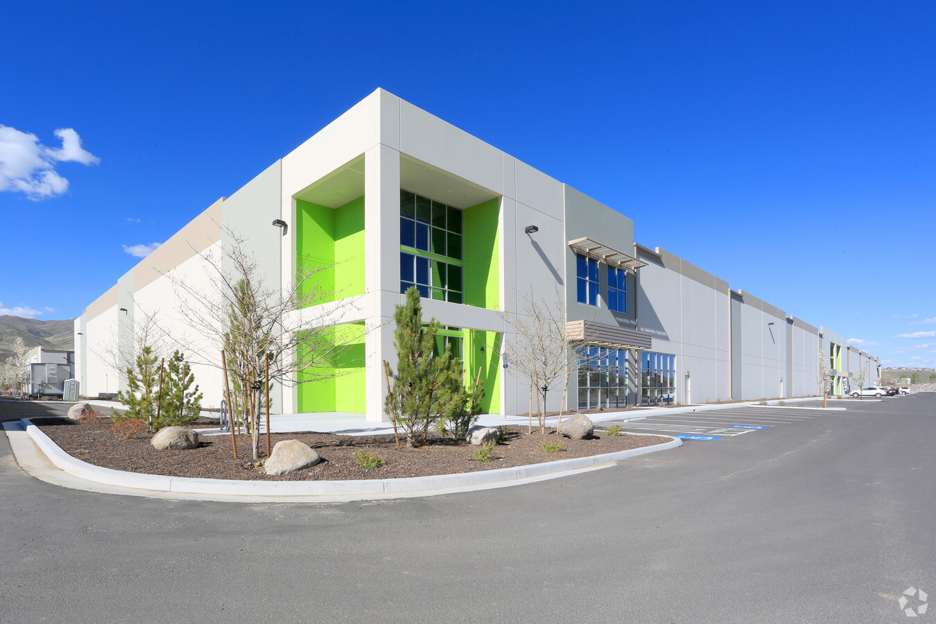
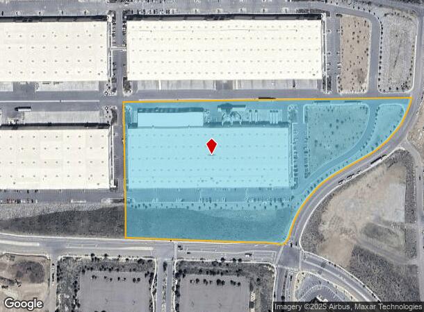
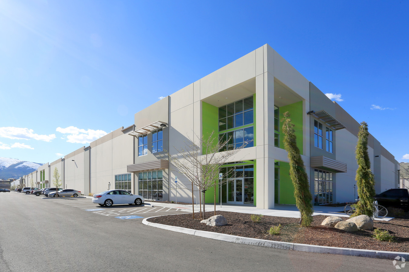
Property Record
375 Cabela Dr, Verdi, NV 89439

NEARBY LISTINGS FOR SALE OR LEASE
Property Detail
375 Cabela Dr
Reno, NV
_Unspecified
038-870-32
PM 5346 LOT C-4
Industrialgeneral
Washoe
X
Nevada
32031C3014G
c-4
2023
13.56 AC
2024
S Outlying Washoe Cty
002302
Reno/Sparks
182,000 SF
DEMOGRAPHICS near 375 Cabela Dr
1 Mile
3 Mile
5 Mile
2024 Total Population
1,869
9,486
27,561
2029 Population
1,965
10,034
28,961
Pop Growth 2024-2029
+ 5.14%
+ 5.78%
+ 5.08%
Average Age
49
51
44
2024 Total Households
833
4,132
11,369
HH Growth 2024-2029
+ 5.16%
+ 5.95%
+ 5.25%
Median Household Inc
$81,090
$121,391
$105,955
Avg Household Size
2.20
2.30
2.40
2024 Avg HH Vehicles
2.00
2.00
2.00
Median Home Value
$679,155
$680,925
$586,219
Median Year Built
2000
2006
2001
Nearby Places
- Restaurants
- Banks
- Shops
- Fitness
- Groceries
PUBLIC TRANSPORTATION
COMMUTER RAIL
Reno (California Zephyr - Amtrak)
DRIVE
WALK
Distance
Reno (California Zephyr - Amtrak)
15 min
9.8 mi
AIRPORT
Reno/Tahoe International
DRIVE
WALK
Distance
Reno/Tahoe International
37 min
16.3 mi
Freight Ports
Port of Stockton
DRIVE
WALK
Distance
Port of Stockton
198 min
170.6 mi
SALE & LEASE HISTORY
LISTING DATE
SALE/LEASE

Mar 22, 2017
For Lease
Feb 10, 2022
For Lease
Nearby Properties
Address
Land Use
TOTAL SIZE
Lot Size
Zoning
Address
Land Use
TOTAL SIZE
Lot Size
Zoning
359,209 SF
8.83 AC
HC
Address
Land Use
TOTAL SIZE
Lot Size
Zoning
127,616 SF
20.80 AC
AC
Address
Land Use
TOTAL SIZE
Lot Size
Zoning
221,000 SF
13.78 AC
IC
Address
Land Use
TOTAL SIZE
Lot Size
Zoning
206,891 SF
13.81 AC
IC
Address
Land Use
TOTAL SIZE
Lot Size
Zoning
182,656 SF
10.50 AC
IC
Address
Land Use
TOTAL SIZE
Lot Size
Zoning
1,200 SF
29.76 AC
MS
Address
Land Use
TOTAL SIZE
Lot Size
Zoning
440 AC
SF6 15% /
Address
Land Use
TOTAL SIZE
Lot Size
Zoning
14,540 SF
10.20 AC
HC
Address
Land Use
TOTAL SIZE
Lot Size
Zoning
0.73 AC
LAR1
Address
Land Use
TOTAL SIZE
Lot Size
Zoning
252,869 SF
10.77 AC
MF14 97% /
Address
Land Use
TOTAL SIZE
Lot Size
Zoning
23,438 SF
11.25 AC
MS
Address
Land Use
TOTAL SIZE
Lot Size
Zoning
133,701 SF
21.38 AC
I
Address
Land Use
TOTAL SIZE
Lot Size
Zoning
257,834 SF
14.94 AC
MS
Address
Land Use
TOTAL SIZE
Lot Size
Zoning
242.86 AC
SF9 12% /
Address
Land Use
TOTAL SIZE
Lot Size
Zoning
88,560 SF
4 AC
I
Address
Land Use
TOTAL SIZE
Lot Size
Zoning
170,090 SF
11.60 AC
MS 91% / S
Address
Land Use
TOTAL SIZE
Lot Size
Zoning
112.77 AC
OS 47%/PF
Address
Land Use
TOTAL SIZE
Lot Size
Zoning
15,588 SF
5.43 AC
GC
Address
Land Use
TOTAL SIZE
Lot Size
Zoning
115,848 SF
9.61 AC
PD
Address
Land Use
TOTAL SIZE
Lot Size
Zoning
167.74 AC
OS 11%/SF6
Address
Land Use
TOTAL SIZE
Lot Size
Zoning
643.88 AC
SF6 13% /
Address
Land Use
TOTAL SIZE
Lot Size
Zoning
678 SF
76.94 AC
SF6 34%/ S
Address
Land Use
TOTAL SIZE
Lot Size
Zoning
2,928.64 AC
OS
Address
Land Use
TOTAL SIZE
Lot Size
Zoning
12,003 SF
18.23 AC
GR
Address
Land Use
TOTAL SIZE
Lot Size
Zoning
1,056 SF
135.74 AC
OS 51% / S
Address
Land Use
TOTAL SIZE
Lot Size
Zoning
49.20 AC
RR15
Address
Land Use
TOTAL SIZE
Lot Size
Zoning
61.14 AC
OS 29% / A
Address
Land Use
TOTAL SIZE
Lot Size
Zoning
42,026 SF
5.79 AC
PD
Address
Land Use
TOTAL SIZE
Lot Size
Zoning
112.42 AC
SF9 52% /
The World's #1 Commercial Real Estate Marketplace
Connect with us
© 2025 CoStar Group
The information above has been obtained from sources believed reliable. While we do not doubt its accuracy we have not verified it and make no guarantee, warranty or representation about it. It is your responsibility to independently confirm its accuracy and completeness. Any projections, opinions, assumptions, or estimates used are for example only and do not represent the current or future performance of the property. The value of this transaction to you depends on tax and other factors which should be evaluated by your tax, financial, and legal advisors. You and your advisors should conduct a careful, independent investigation of the property to determine to your satisfaction the suitability of the property for your needs.