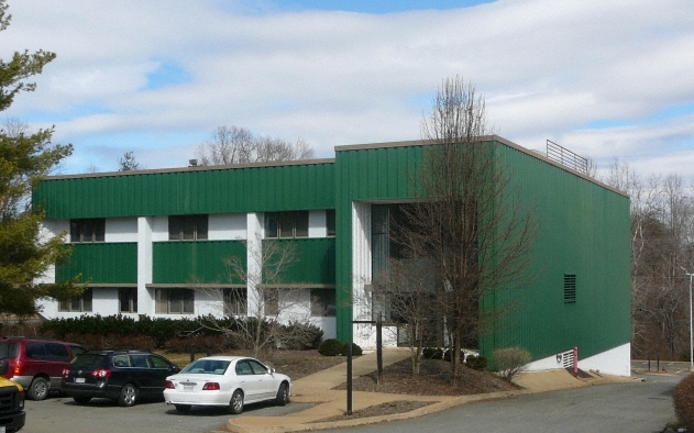
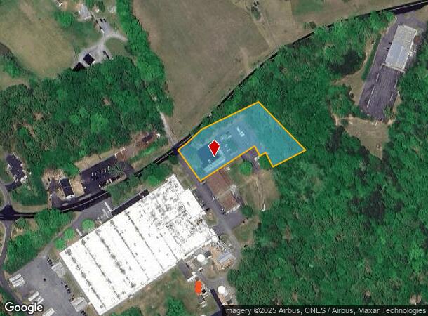
Property Record
379 Reas Ford Rd, Earlysville, VA 22936
NEARBY LISTINGS FOR SALE OR LEASE
Property Detail
379 Reas Ford Rd
03100-00-00-021A1
ACREAGE PARCEL A
Medicalbuilding
Albemarle
X
Virginia
51079C0200C
1.90 AC
0
Charlottesville
2024
Other Market Areas
010202
Charlottesville, VA
20,196 SF
DEMOGRAPHICS near 379 Reas Ford Rd
1 Mile
3 Mile
5 Mile
2024 Total Population
472
5,977
29,247
2029 Population
488
6,238
30,420
Pop Growth 2024-2029
+ 3.39%
+ 4.37%
+ 4.01%
Average Age
48
44
41
2024 Total Households
185
2,390
11,470
HH Growth 2024-2029
+ 3.78%
+ 4.81%
+ 4.43%
Median Household Inc
$123,610
$119,068
$97,485
Avg Household Size
2.60
2.50
2.50
2024 Avg HH Vehicles
3.00
2.00
2.00
Median Home Value
$637,362
$458,823
$386,924
Median Year Built
1982
1984
1986
Nearby Places
- Restaurants
- Banks
- Shops
- Fitness
- Groceries
PUBLIC TRANSPORTATION
AIRPORT
Charlottesville-Albemarle
DRIVE
WALK
Distance
Charlottesville-Albemarle
10 min
4.9 mi
Freight Ports
Virginia Port Authority - Richmond
DRIVE
WALK
Distance
Virginia Port Authority - Richmond
113 min
87.0 mi
Nearby Properties
Address
Land Use
TOTAL SIZE
Lot Size
Zoning
Address
Land Use
TOTAL SIZE
Lot Size
Zoning
17.73 AC
R15 RESIDE
Address
Land Use
TOTAL SIZE
Lot Size
Zoning
36,136 SF
626.08 AC
RURAL AREA
Address
Land Use
TOTAL SIZE
Lot Size
Zoning
60,697 SF
12.93 AC
PLANNED DE
Address
Land Use
TOTAL SIZE
Lot Size
Zoning
67,793 SF
1.25 AC
PLANNED DE
Address
Land Use
TOTAL SIZE
Lot Size
Zoning
87,627 SF
7.77 AC
PDMC
Address
Land Use
TOTAL SIZE
Lot Size
Zoning
12,750 SF
15.32 AC
PDMC
Address
Land Use
TOTAL SIZE
Lot Size
Zoning
74,213 SF
2.02 AC
PDMC
Address
Land Use
TOTAL SIZE
Lot Size
Zoning
460.82 AC
RURAL AREA
Address
Land Use
TOTAL SIZE
Lot Size
Zoning
24.46 AC
R15 RESIDE
Address
Land Use
TOTAL SIZE
Lot Size
Zoning
72,670 SF
9.36 AC
LIGHT INDU
Address
Land Use
TOTAL SIZE
Lot Size
Zoning
49,580 SF
13.16 AC
LIGHT INDU
Address
Land Use
TOTAL SIZE
Lot Size
Zoning
215,358 SF
23.30 AC
LIGHT INDU
Address
Land Use
TOTAL SIZE
Lot Size
Zoning
41,870 SF
11.16 AC
RURAL AREA
Address
Land Use
TOTAL SIZE
Lot Size
Zoning
41,746 SF
2.60 AC
PLANNED DE
Address
Land Use
TOTAL SIZE
Lot Size
Zoning
24,228 SF
4.62 AC
RURAL AREA
Address
Land Use
TOTAL SIZE
Lot Size
Zoning
50,656 SF
7.10 AC
PDIP
Address
Land Use
TOTAL SIZE
Lot Size
Zoning
46,445 SF
4.86 AC
PDIP
Address
Land Use
TOTAL SIZE
Lot Size
Zoning
18,924 SF
20.64 AC
LIGHT INDU
Address
Land Use
TOTAL SIZE
Lot Size
Zoning
19,680 SF
10.70 AC
RURAL AREA
Address
Land Use
TOTAL SIZE
Lot Size
Zoning
11.07 AC
PRD
Address
Land Use
TOTAL SIZE
Lot Size
Zoning
9,747 SF
3.29 AC
RURAL AREA
Address
Land Use
TOTAL SIZE
Lot Size
Zoning
8.10 AC
LIGHT INDU
Address
Land Use
TOTAL SIZE
Lot Size
Zoning
73,799 SF
11 AC
RURAL AREA
Address
Land Use
TOTAL SIZE
Lot Size
Zoning
10,080 SF
2.97 AC
RURAL AREA
Address
Land Use
TOTAL SIZE
Lot Size
Zoning
12,765 SF
2.18 AC
LIGHT INDU
Address
Land Use
TOTAL SIZE
Lot Size
Zoning
3,532 SF
4.15 AC
C1 COMMERC
Address
Land Use
TOTAL SIZE
Lot Size
Zoning
7.41 AC
LIGHT INDU
The World's #1 Commercial Real Estate Marketplace
Connect with us
© 2025 CoStar Group
The information above has been obtained from sources believed reliable. While we do not doubt its accuracy we have not verified it and make no guarantee, warranty or representation about it. It is your responsibility to independently confirm its accuracy and completeness. Any projections, opinions, assumptions, or estimates used are for example only and do not represent the current or future performance of the property. The value of this transaction to you depends on tax and other factors which should be evaluated by your tax, financial, and legal advisors. You and your advisors should conduct a careful, independent investigation of the property to determine to your satisfaction the suitability of the property for your needs.