Property Record
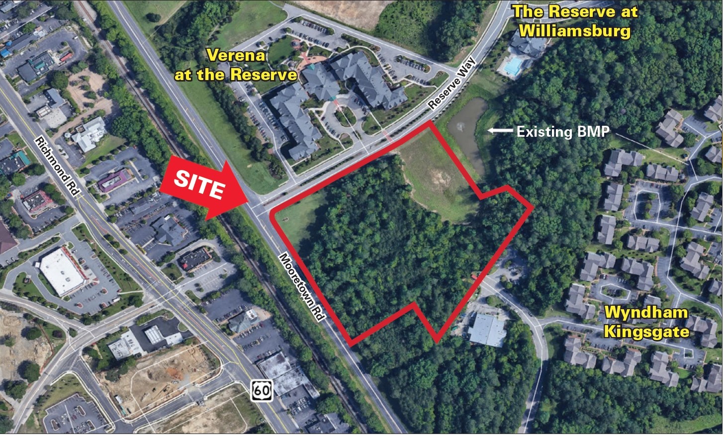
3800 Mooretown Rd, Williamsburg, VA 23185
NEARBY LISTINGS FOR SALE OR LEASE
Property Detail
3800 Mooretown Rd
D15A-0393-4728
The Reserve At Williamsburg
Retirementnursinghomecombined
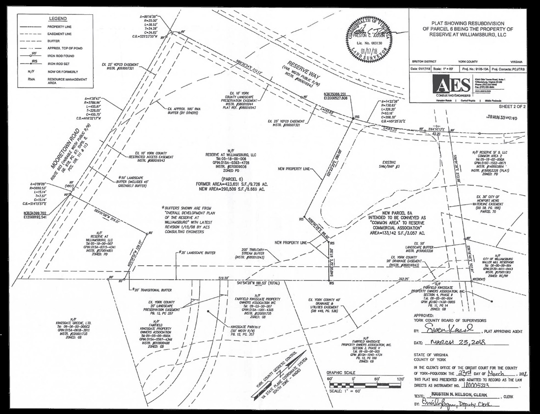
RESERVE AT WILLIAMSBURG (THE) NEW PARCEL 6 (RESUBDIVISION PLAT)
X
York
51095C0136D
Virginia
2024
6.67 AC
2024
York
370100
Hampton Roads
78,121 SF
Virginia Beach-Norfolk-Newport News, VA-NC
DEMOGRAPHICS near 3800 Mooretown Rd
1 Mile
3 Mile
5 Mile
2024 Total Population
9,731
42,143
81,469
2029 Population
10,732
45,932
88,628
Pop Growth 2024-2029
+ 10.29%
+ 8.99%
+ 8.79%
Average Age
37
41
43
2024 Total Households
3,193
16,704
32,601
HH Growth 2024-2029
+ 12.68%
+ 10.00%
+ 9.34%
Median Household Inc
$61,645
$76,418
$85,018
Avg Household Size
2.00
2.20
2.30
2024 Avg HH Vehicles
2.00
2.00
2.00
Median Home Value
$283,257
$368,974
$376,898
Median Year Built
1993
1993
1994
Nearby Places
- Restaurants
- Banks
- Shops
- Fitness
- Groceries
PUBLIC TRANSPORTATION
COMMUTER RAIL
Williamsburg Amtrak Station (Northeast Regional - Amtrak)
DRIVE
WALK
Distance
Williamsburg Amtrak Station (Northeast Regional - Amtrak)
4 min
1.3 mi
AIRPORT
Newport News/Williamsburg International
DRIVE
WALK
Distance
Newport News/Williamsburg International
28 min
17.6 mi
Freight Ports
Virginia Port Authority - Newport News
DRIVE
WALK
Distance
Virginia Port Authority - Newport News
41 min
31.7 mi
SALE & LEASE HISTORY
LISTING DATE
SALE/LEASE

Apr 30, 2018
For Sale
Nearby Properties
Address
Land Use
TOTAL SIZE
Lot Size
Zoning
Address
Land Use
TOTAL SIZE
Lot Size
Zoning
55,136 SF
348.94 AC
WM (WILLIA
Address
Land Use
TOTAL SIZE
Lot Size
Zoning
83,748 SF
B-3 (GENER
Address
Land Use
TOTAL SIZE
Lot Size
Zoning
87,083 SF
55.74 AC
WM (WILLIA
Address
Land Use
TOTAL SIZE
Lot Size
Zoning
88,000 SF
11.48 AC
MS (MUSEUM
Address
Land Use
TOTAL SIZE
Lot Size
Zoning
71,980 SF
6 AC
ED-2 (ECON
Address
Land Use
TOTAL SIZE
Lot Size
Zoning
43,686 SF
50.01 AC
R5 MULTIFA
Address
Land Use
TOTAL SIZE
Lot Size
Zoning
52,774 SF
9.07 AC
PLANNED DE
Address
Land Use
TOTAL SIZE
Lot Size
Zoning
263,288 SF
34.22 AC
MU MIXED U
Address
Land Use
TOTAL SIZE
Lot Size
Zoning
625,352 SF
13.60 AC
MU MIXED U
Address
Land Use
TOTAL SIZE
Lot Size
Zoning
109,842 SF
17.34 AC
ED-C (ECON
Address
Land Use
TOTAL SIZE
Lot Size
Zoning
109,045 SF
18.31 AC
RS-2 (SING
Address
Land Use
TOTAL SIZE
Lot Size
Zoning
540.65 AC
PL PUBLIC
Address
Land Use
TOTAL SIZE
Lot Size
Zoning
164,647 SF
34.11 AC
MS (MUSEUM
Address
Land Use
TOTAL SIZE
Lot Size
Zoning
182,259 SF
3.60 AC
B-1 (DOWNT
Address
Land Use
TOTAL SIZE
Lot Size
Zoning
501.93 AC
WM (WILLIA
Address
Land Use
TOTAL SIZE
Lot Size
Zoning
32,730 SF
4.89 AC
ED-2 (ECON
Address
Land Use
TOTAL SIZE
Lot Size
Zoning
113,000 SF
22.20 AC
WM (WILLIA
Address
Land Use
TOTAL SIZE
Lot Size
Zoning
800 SF
72.70 AC
R5 MULTIFA
Address
Land Use
TOTAL SIZE
Lot Size
Zoning
14,448 SF
6.94 AC
WM (WILLIA
Address
Land Use
TOTAL SIZE
Lot Size
Zoning
58,107 SF
14.62 AC
ED-C (ECON
Address
Land Use
TOTAL SIZE
Lot Size
Zoning
167,811 SF
51.70 AC
PUDR PLANN
Address
Land Use
TOTAL SIZE
Lot Size
Zoning
36,545 SF
11.48 AC
MS (MUSEUM
Address
Land Use
TOTAL SIZE
Lot Size
Zoning
55,122 SF
11.33 AC
LB-1 (DOWN
Address
Land Use
TOTAL SIZE
Lot Size
Zoning
96,955 SF
4.12 AC
ED-C (ECON
Address
Land Use
TOTAL SIZE
Lot Size
Zoning
60,344 SF
11.41 AC
LB-4 (LIMI
Address
Land Use
TOTAL SIZE
Lot Size
Zoning
149,179 SF
3 AC
ED-C (ECON
Address
Land Use
TOTAL SIZE
Lot Size
Zoning
42,914 SF
16.58 AC
MU MIXED U
Address
Land Use
TOTAL SIZE
Lot Size
Zoning
53,014 SF
34.74 AC
MS (MUSEUM
Address
Land Use
TOTAL SIZE
Lot Size
Zoning
12,444 SF
26.96 AC
RM-2 (MULT
Address
Land Use
TOTAL SIZE
Lot Size
Zoning
154,809 SF
7.31 AC
PLANNED DE
The World's #1 Commercial Real Estate Marketplace
Connect with us
© 2025 CoStar Group
The information above has been obtained from sources believed reliable. While we do not doubt its accuracy we have not verified it and make no guarantee, warranty or representation about it. It is your responsibility to independently confirm its accuracy and completeness. Any projections, opinions, assumptions, or estimates used are for example only and do not represent the current or future performance of the property. The value of this transaction to you depends on tax and other factors which should be evaluated by your tax, financial, and legal advisors. You and your advisors should conduct a careful, independent investigation of the property to determine to your satisfaction the suitability of the property for your needs.