Property Record
3803 Highway 41 N, Evansville, IN 47711
NEARBY LISTINGS FOR SALE OR LEASE
-
-
View all Evansville listings for lease on LoopNet.com
Property Detail
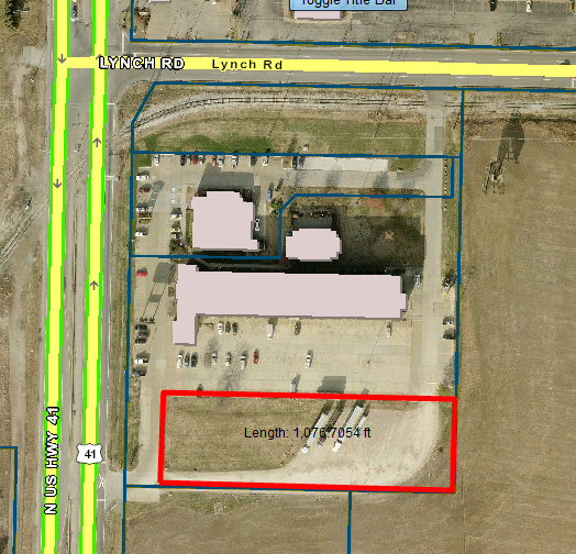
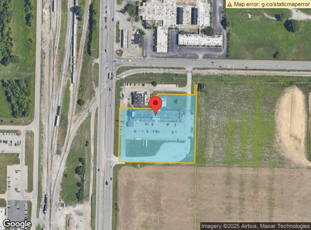
3803 Highway 41 N
Evansville, IN-KY
Drury Minor Sub
82-06-09-034-406.001-020
DRURY MINOR SUB LOT 1
Hotelormotel
Vanderburgh
X
Indiana
18163C0118E
1
2023
3.98 AC
2023
Northside/Airport
010207
Evansville
71,362 SF
DEMOGRAPHICS near 3803 Highway 41 N
1 Mile
3 Mile
5 Mile
2024 Total Population
3,201
57,609
134,243
2029 Population
3,196
57,841
134,856
Pop Growth 2024-2029
(0.16%)
+ 0.40%
+ 0.46%
Average Age
41
41
40
2024 Total Households
1,233
24,823
57,811
HH Growth 2024-2029
(0.24%)
+ 0.36%
+ 0.48%
Median Household Inc
$45,260
$48,827
$51,117
Avg Household Size
2.20
2.20
2.20
2024 Avg HH Vehicles
2.00
2.00
2.00
Median Home Value
$83,757
$128,348
$136,275
Median Year Built
1951
1964
1965
Nearby Places
- Restaurants
- Banks
- Shops
- Fitness
- Groceries
PUBLIC TRANSPORTATION
AIRPORT
Evansville Regional
DRIVE
WALK
Distance
Evansville Regional
5 min
2.1 mi
Freight Ports
Port of Toledo
DRIVE
WALK
Distance
Port of Toledo
454 min
391.2 mi
SALE & LEASE HISTORY
LISTING DATE
SALE/LEASE

Sep 24, 2016
For Sale
Apr 12, 2017
For Lease
Nearby Properties
Address
Land Use
TOTAL SIZE
Lot Size
Zoning
Address
Land Use
TOTAL SIZE
Lot Size
Zoning
51,342 SF
4.42 AC
Address
Land Use
TOTAL SIZE
Lot Size
Zoning
21,831 SF
3.03 AC
Address
Land Use
TOTAL SIZE
Lot Size
Zoning
38,566 SF
10.50 AC
Address
Land Use
TOTAL SIZE
Lot Size
Zoning
992,266 SF
116.92 AC
Address
Land Use
TOTAL SIZE
Lot Size
Zoning
194,564 SF
24.47 AC
Address
Land Use
TOTAL SIZE
Lot Size
Zoning
223,202 SF
2.28 AC
Address
Land Use
TOTAL SIZE
Lot Size
Zoning
784,971 SF
15.37 AC
Address
Land Use
TOTAL SIZE
Lot Size
Zoning
4,165 SF
17.92 AC
Address
Land Use
TOTAL SIZE
Lot Size
Zoning
4,831 SF
22.16 AC
Address
Land Use
TOTAL SIZE
Lot Size
Zoning
20,286 SF
4.57 AC
Address
Land Use
TOTAL SIZE
Lot Size
Zoning
162,726 SF
22.71 AC
Address
Land Use
TOTAL SIZE
Lot Size
Zoning
5,005 SF
20.13 AC
Address
Land Use
TOTAL SIZE
Lot Size
Zoning
10,619 SF
29.18 AC
Address
Land Use
TOTAL SIZE
Lot Size
Zoning
61,652 SF
15.02 AC
Address
Land Use
TOTAL SIZE
Lot Size
Zoning
311,804 SF
31.94 AC
Address
Land Use
TOTAL SIZE
Lot Size
Zoning
66,456 SF
39.47 AC
Address
Land Use
TOTAL SIZE
Lot Size
Zoning
3,950 SF
16.77 AC
Address
Land Use
TOTAL SIZE
Lot Size
Zoning
16,292 SF
6.87 AC
Address
Land Use
TOTAL SIZE
Lot Size
Zoning
1,053,789 SF
52.82 AC
Address
Land Use
TOTAL SIZE
Lot Size
Zoning
100,706 SF
13.61 AC
Address
Land Use
TOTAL SIZE
Lot Size
Zoning
17,640 SF
12.13 AC
Address
Land Use
TOTAL SIZE
Lot Size
Zoning
298,374 SF
18.16 AC
Address
Land Use
TOTAL SIZE
Lot Size
Zoning
68,706 SF
13.46 AC
Address
Land Use
TOTAL SIZE
Lot Size
Zoning
39,264 SF
45.28 AC
Address
Land Use
TOTAL SIZE
Lot Size
Zoning
23,796 SF
17.29 AC
Address
Land Use
TOTAL SIZE
Lot Size
Zoning
4,284 SF
13.14 AC
Address
Land Use
TOTAL SIZE
Lot Size
Zoning
51,150 SF
7.51 AC
Address
Land Use
TOTAL SIZE
Lot Size
Zoning
185,563 SF
12.47 AC
Address
Land Use
TOTAL SIZE
Lot Size
Zoning
69,144 SF
3.28 AC
Address
Land Use
TOTAL SIZE
Lot Size
Zoning
99,882 SF
15.01 AC
The World's #1 Commercial Real Estate Marketplace
Connect with us
© 2025 CoStar Group
The information above has been obtained from sources believed reliable. While we do not doubt its accuracy we have not verified it and make no guarantee, warranty or representation about it. It is your responsibility to independently confirm its accuracy and completeness. Any projections, opinions, assumptions, or estimates used are for example only and do not represent the current or future performance of the property. The value of this transaction to you depends on tax and other factors which should be evaluated by your tax, financial, and legal advisors. You and your advisors should conduct a careful, independent investigation of the property to determine to your satisfaction the suitability of the property for your needs.