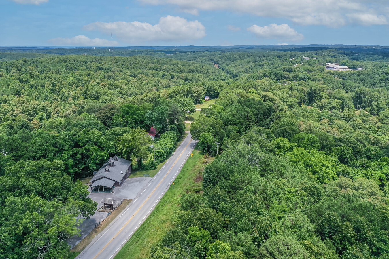
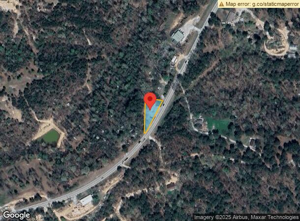
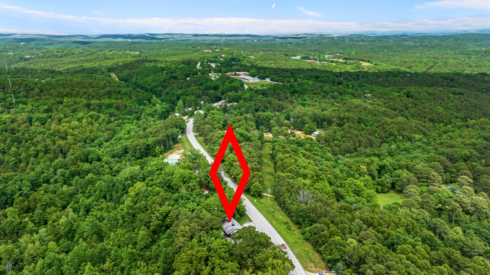
Property Record
381 Highway 23 S, Eureka Springs, AR 72632
NEARBY LISTINGS FOR SALE OR LEASE
-
-
View all Eureka Springs listings for sale on LoopNet.com
Property Detail
381 Highway 23 S
001-07921-000
28-20-26
Storebuilding
PT NE NE
X
Carroll
05015C0225B
Arkansas
2023
0.75 AC
2024
Arkansas North Area
950201
Other Market Areas
3,840 SF
DEMOGRAPHICS near 381 Highway 23 S
1 Mile
3 Mile
5 Mile
2024 Total Population
298
3,090
4,503
2029 Population
306
3,180
4,661
Pop Growth 2024-2029
+ 2.68%
+ 2.91%
+ 3.51%
Average Age
50
50
50
2024 Total Households
146
1,588
2,270
HH Growth 2024-2029
+ 2.05%
+ 2.64%
+ 3.22%
Median Household Inc
$45,625
$44,467
$47,191
Avg Household Size
2.00
1.90
1.90
2024 Avg HH Vehicles
2.00
2.00
2.00
Median Home Value
$199,999
$211,783
$212,500
Median Year Built
1987
1975
1983
Nearby Places
- Restaurants
- Banks
- Shops
- Fitness
- Groceries
SALE & LEASE HISTORY
LISTING DATE
SALE/LEASE

Sep 16, 2021
For Sale
May 22, 2023
For Sale
Nearby Properties
Address
Land Use
TOTAL SIZE
Lot Size
Zoning
Address
Land Use
TOTAL SIZE
Lot Size
Zoning
11,144 SF
5.57 AC
Address
Land Use
TOTAL SIZE
Lot Size
Zoning
52,388 SF
3 AC
Address
Land Use
TOTAL SIZE
Lot Size
Zoning
40,536 SF
6 AC
Address
Land Use
TOTAL SIZE
Lot Size
Zoning
46,090 SF
Address
Land Use
TOTAL SIZE
Lot Size
Zoning
39,349 SF
3.32 AC
Address
Land Use
TOTAL SIZE
Lot Size
Zoning
20,457 SF
8.28 AC
Address
Land Use
TOTAL SIZE
Lot Size
Zoning
23,493 SF
2.77 AC
Address
Land Use
TOTAL SIZE
Lot Size
Zoning
23,600 SF
3 AC
Address
Land Use
TOTAL SIZE
Lot Size
Zoning
28,799 SF
37.44 AC
Address
Land Use
TOTAL SIZE
Lot Size
Zoning
16,521 SF
0.11 AC
Address
Land Use
TOTAL SIZE
Lot Size
Zoning
2,384 SF
6.43 AC
Address
Land Use
TOTAL SIZE
Lot Size
Zoning
17,154 SF
2.13 AC
Address
Land Use
TOTAL SIZE
Lot Size
Zoning
12,677 SF
1.45 AC
Address
Land Use
TOTAL SIZE
Lot Size
Zoning
6,511 SF
1.34 AC
Address
Land Use
TOTAL SIZE
Lot Size
Zoning
23,600 SF
0.09 AC
Address
Land Use
TOTAL SIZE
Lot Size
Zoning
13,770 SF
0.14 AC
Address
Land Use
TOTAL SIZE
Lot Size
Zoning
30,000 SF
32.84 AC
Address
Land Use
TOTAL SIZE
Lot Size
Zoning
23,979 SF
4.33 AC
Address
Land Use
TOTAL SIZE
Lot Size
Zoning
2,732 SF
0.69 AC
Address
Land Use
TOTAL SIZE
Lot Size
Zoning
6,916 SF
468.46 AC
Address
Land Use
TOTAL SIZE
Lot Size
Zoning
27,972 SF
8.82 AC
Address
Land Use
TOTAL SIZE
Lot Size
Zoning
23,910 SF
2.75 AC
Address
Land Use
TOTAL SIZE
Lot Size
Zoning
16,121 SF
2.40 AC
Address
Land Use
TOTAL SIZE
Lot Size
Zoning
27,152 SF
2.07 AC
Address
Land Use
TOTAL SIZE
Lot Size
Zoning
17,946 SF
0.91 AC
Address
Land Use
TOTAL SIZE
Lot Size
Zoning
8,760 SF
2.54 AC
Address
Land Use
TOTAL SIZE
Lot Size
Zoning
19,340 SF
2.07 AC
Address
Land Use
TOTAL SIZE
Lot Size
Zoning
11,072 SF
0.53 AC
Address
Land Use
TOTAL SIZE
Lot Size
Zoning
12,730 SF
0.04 AC
Address
Land Use
TOTAL SIZE
Lot Size
Zoning
11,484 SF
9.67 AC
The World's #1 Commercial Real Estate Marketplace
Connect with us
© 2025 CoStar Group
The information above has been obtained from sources believed reliable. While we do not doubt its accuracy we have not verified it and make no guarantee, warranty or representation about it. It is your responsibility to independently confirm its accuracy and completeness. Any projections, opinions, assumptions, or estimates used are for example only and do not represent the current or future performance of the property. The value of this transaction to you depends on tax and other factors which should be evaluated by your tax, financial, and legal advisors. You and your advisors should conduct a careful, independent investigation of the property to determine to your satisfaction the suitability of the property for your needs.