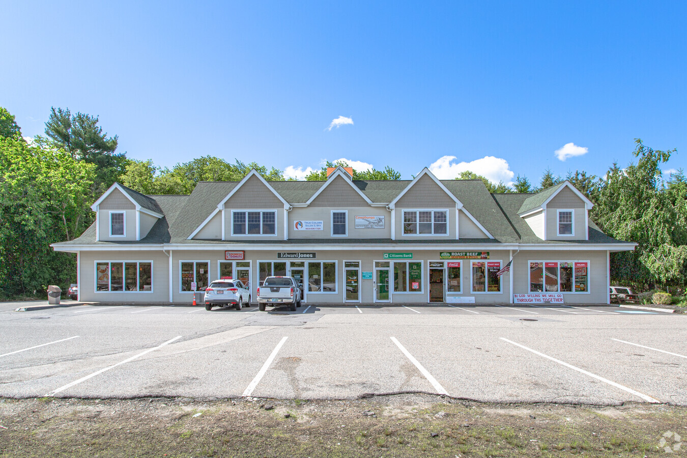
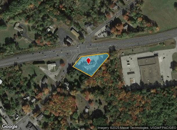
Property Record
381 Portsmouth Ave, Greenland, NH 03840
NEARBY LISTINGS FOR SALE OR LEASE
-
-
View all Greenland listings for lease on LoopNet.com
Property Detail
381 Portsmouth Ave
GRNL-000000-000004-000021-U000000
Rockingham
Regionalshoppingcenterormallwithanchorstore
New Hampshire
X
21
33015C0265F
1.04 AC
2023
Rockingham
2023
Boston
107500
Boston-Cambridge-Newton, MA-NH
9,133 SF
DEMOGRAPHICS near 381 Portsmouth Ave
1 Mile
3 Mile
5 Mile
2024 Total Population
1,479
12,559
44,268
2029 Population
1,540
13,061
46,225
Pop Growth 2024-2029
+ 4.12%
+ 4.00%
+ 4.42%
Average Age
44
44
45
2024 Total Households
577
5,304
19,483
HH Growth 2024-2029
+ 3.99%
+ 3.92%
+ 4.40%
Median Household Inc
$126,229
$113,815
$110,901
Avg Household Size
2.60
2.30
2.20
2024 Avg HH Vehicles
2.00
2.00
2.00
Median Home Value
$615,574
$537,445
$638,661
Median Year Built
1986
1982
1974
Nearby Places
- Restaurants
- Banks
- Shops
- Fitness
- Groceries
PUBLIC TRANSPORTATION
COMMUTER RAIL
Exeter (Downeaster - Amtrak)
DRIVE
WALK
Distance
Exeter (Downeaster - Amtrak)
20 min
9.7 mi
AIRPORT
Portsmouth International at Pease
DRIVE
WALK
Distance
Portsmouth International at Pease
9 min
4.3 mi
Freight Ports
Port of Boston
DRIVE
WALK
Distance
Port of Boston
75 min
57.1 mi
SALE & LEASE HISTORY
LISTING DATE
SALE/LEASE

May 04, 2020
For Lease
Nearby Properties
Address
Land Use
TOTAL SIZE
Lot Size
Zoning
Address
Land Use
TOTAL SIZE
Lot Size
Zoning
20.87 AC
OR
Address
Land Use
TOTAL SIZE
Lot Size
Zoning
11.23 AC
OR
Address
Land Use
TOTAL SIZE
Lot Size
Zoning
81,652 SF
14.40 AC
G1
Address
Land Use
TOTAL SIZE
Lot Size
Zoning
33.40 AC
IND
Address
Land Use
TOTAL SIZE
Lot Size
Zoning
114,194 SF
G1
Address
Land Use
TOTAL SIZE
Lot Size
Zoning
87,917 SF
29.26 AC
RA
Address
Land Use
TOTAL SIZE
Lot Size
Zoning
190,444 SF
20.38 AC
G1
Address
Land Use
TOTAL SIZE
Lot Size
Zoning
137,809 SF
13.18 AC
ABC
Address
Land Use
TOTAL SIZE
Lot Size
Zoning
28.05 AC
GA/MH
Address
Land Use
TOTAL SIZE
Lot Size
Zoning
99,104 SF
7.31 AC
ABC
Address
Land Use
TOTAL SIZE
Lot Size
Zoning
20.53 AC
PI
Address
Land Use
TOTAL SIZE
Lot Size
Zoning
102,323 SF
22.02 AC
ABC
Address
Land Use
TOTAL SIZE
Lot Size
Zoning
108,116 SF
18.48 AC
IND
Address
Land Use
TOTAL SIZE
Lot Size
Zoning
25.08 AC
NRP
Address
Land Use
TOTAL SIZE
Lot Size
Zoning
72,694 SF
36.70 AC
I
Address
Land Use
TOTAL SIZE
Lot Size
Zoning
132,784 SF
22.32 AC
IND
Address
Land Use
TOTAL SIZE
Lot Size
Zoning
100,650 SF
20.09 AC
ABC
Address
Land Use
TOTAL SIZE
Lot Size
Zoning
89,689 SF
9.17 AC
G2
Address
Land Use
TOTAL SIZE
Lot Size
Zoning
107,657 SF
8.67 AC
IND
Address
Land Use
TOTAL SIZE
Lot Size
Zoning
207,279 SF
33.07 AC
I
Address
Land Use
TOTAL SIZE
Lot Size
Zoning
50,700 SF
5.32 AC
OR
Address
Land Use
TOTAL SIZE
Lot Size
Zoning
72,193 SF
G1
Address
Land Use
TOTAL SIZE
Lot Size
Zoning
74,653 SF
1.68 AC
PI
Address
Land Use
TOTAL SIZE
Lot Size
Zoning
83,523 SF
4.96 AC
AI
Address
Land Use
TOTAL SIZE
Lot Size
Zoning
50,496 SF
I
Address
Land Use
TOTAL SIZE
Lot Size
Zoning
53,916 SF
I
Address
Land Use
TOTAL SIZE
Lot Size
Zoning
44.31 AC
NRP
Address
Land Use
TOTAL SIZE
Lot Size
Zoning
83,021 SF
3.54 AC
RES
Address
Land Use
TOTAL SIZE
Lot Size
Zoning
21,318 SF
3.98 AC
OR
Address
Land Use
TOTAL SIZE
Lot Size
Zoning
52,769 SF
ABC
The World's #1 Commercial Real Estate Marketplace
Connect with us
© 2025 CoStar Group
The information above has been obtained from sources believed reliable. While we do not doubt its accuracy we have not verified it and make no guarantee, warranty or representation about it. It is your responsibility to independently confirm its accuracy and completeness. Any projections, opinions, assumptions, or estimates used are for example only and do not represent the current or future performance of the property. The value of this transaction to you depends on tax and other factors which should be evaluated by your tax, financial, and legal advisors. You and your advisors should conduct a careful, independent investigation of the property to determine to your satisfaction the suitability of the property for your needs.