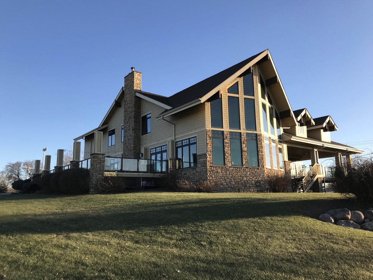
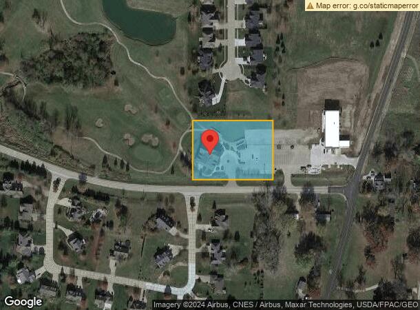
Property Record
3851 Forest Grove Dr, Le Claire, IA 52753
NEARBY LISTINGS FOR SALE OR LEASE
-
-
View all Le Claire listings for sale on LoopNet.com
Property Detail
3851 Forest Grove Dr
Davenport-Moline-Rock Island, IA-IL
Pebble Creek North 4Th Add
850433228
PEBBLE CREEK NORTH 4TH ADD LOT: 028 PEBBLE CREEK NORTH4TH ADD LOT 28
Clubslodgesprofessionalassociations
Scott
X
Iowa
19163C0384G
28
2023
1.95 AC
2024
Outlying Scott County
010104
Davenport/Moline/Rock Island
7,141 SF
DEMOGRAPHICS near 3851 Forest Grove Dr
1 Mile
3 Mile
5 Mile
2024 Total Population
1,339
11,436
31,910
2029 Population
1,330
11,267
31,657
Pop Growth 2024-2029
(0.67%)
(1.48%)
(0.79%)
Average Age
40
41
40
2024 Total Households
491
4,025
11,752
HH Growth 2024-2029
(0.81%)
(1.59%)
(0.89%)
Median Household Inc
$173,809
$98,778
$99,466
Avg Household Size
2.70
2.60
2.60
2024 Avg HH Vehicles
2.00
2.00
2.00
Median Home Value
$461,607
$285,971
$307,745
Median Year Built
2000
1987
1992
Nearby Places
- Restaurants
- Banks
- Shops
- Fitness
- Groceries
PUBLIC TRANSPORTATION
AIRPORT
Quad Cities International
Drive
Walk
Distance
Quad Cities International
32 min
23.2 mi
Freight Ports
Port Milwaukee
Drive
Walk
Distance
Port Milwaukee
227 min
201.3 mi
SALE & LEASE HISTORY
LISTING DATE
SALE/LEASE

Dec 15, 2017
For Sale
Nearby Properties
Address
Land Use
TOTAL SIZE
Lot Size
Zoning
Address
Land Use
TOTAL SIZE
Lot Size
Zoning
85140
14.25 AC
Address
Land Use
TOTAL SIZE
Lot Size
Zoning
135007
58 AC
Address
Land Use
TOTAL SIZE
Lot Size
Zoning
3360
35.63 AC
Address
Land Use
TOTAL SIZE
Lot Size
Zoning
72435
31.43 AC
Address
Land Use
TOTAL SIZE
Lot Size
Zoning
14497
151.81 AC
R1
Address
Land Use
TOTAL SIZE
Lot Size
Zoning
3623
2.54 AC
Address
Land Use
TOTAL SIZE
Lot Size
Zoning
913
8.44 AC
Address
Land Use
TOTAL SIZE
Lot Size
Zoning
63272
15.49 AC
Address
Land Use
TOTAL SIZE
Lot Size
Zoning
54773
12.64 AC
Address
Land Use
TOTAL SIZE
Lot Size
Zoning
11960
7.53 AC
Address
Land Use
TOTAL SIZE
Lot Size
Zoning
27365
3.14 AC
Address
Land Use
TOTAL SIZE
Lot Size
Zoning
13621
2.42 AC
Address
Land Use
TOTAL SIZE
Lot Size
Zoning
5840
2.26 AC
Address
Land Use
TOTAL SIZE
Lot Size
Zoning
18340
9.54 AC
Address
Land Use
TOTAL SIZE
Lot Size
Zoning
14612
5.02 AC
C2
Address
Land Use
TOTAL SIZE
Lot Size
Zoning
1000
8.91 AC
Address
Land Use
TOTAL SIZE
Lot Size
Zoning
7455
1.49 AC
Address
Land Use
TOTAL SIZE
Lot Size
Zoning
35925
2.23 AC
Address
Land Use
TOTAL SIZE
Lot Size
Zoning
11504
2.10 AC
Address
Land Use
TOTAL SIZE
Lot Size
Zoning
1.77 AC
SIL
Address
Land Use
TOTAL SIZE
Lot Size
Zoning
13757
0.79 AC
Address
Land Use
TOTAL SIZE
Lot Size
Zoning
10460
0.50 AC
Address
Land Use
TOTAL SIZE
Lot Size
Zoning
5195
0.50 AC
Address
Land Use
TOTAL SIZE
Lot Size
Zoning
16288
22.97 AC
SIL
Address
Land Use
TOTAL SIZE
Lot Size
Zoning
2650
1.48 AC
Address
Land Use
TOTAL SIZE
Lot Size
Zoning
10200
1.19 AC
Address
Land Use
TOTAL SIZE
Lot Size
Zoning
4264
0.66 AC
Address
Land Use
TOTAL SIZE
Lot Size
Zoning
2368
1.10 AC
Address
Land Use
TOTAL SIZE
Lot Size
Zoning
7365
0.66 AC
Address
Land Use
TOTAL SIZE
Lot Size
Zoning
8748
1.82 AC
Start a new search to find other properties for sale or lease
Connect with us
© 2024 CoStar Group
The information above has been obtained from sources believed reliable. While we do not doubt its accuracy we have not verified it and make no guarantee, warranty or representation about it. It is your responsibility to independently confirm its accuracy and completeness. Any projections, opinions, assumptions, or estimates used are for example only and do not represent the current or future performance of the property. The value of this transaction to you depends on tax and other factors which should be evaluated by your tax, financial, and legal advisors. You and your advisors should conduct a careful, independent investigation of the property to determine to your satisfaction the suitability of the property for your needs.