Property Record
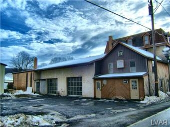
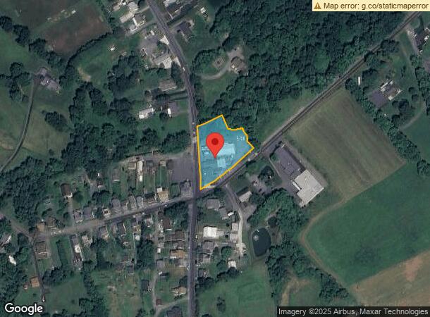
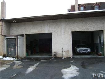
3851 Main Rd E, Emmaus, PA 18049
NEARBY LISTINGS FOR SALE OR LEASE
Property Detail
3851 Main Rd E
Allentown-Bethlehem-Easton, PA-NJ
Minor Subdivision
549355126319-1
LOTS: 040
Autorepair
Lehigh
A
Pennsylvania
42077C0263F
40
2024
1.08 AC
2024
Lehigh Valley
006401
Philadelphia
11,289 SF
DEMOGRAPHICS near 3851 Main Rd E
1 Mile
3 Mile
5 Mile
2024 Total Population
1,118
22,060
72,218
2029 Population
1,118
22,130
72,691
Pop Growth 2024-2029
0.00%
+ 0.32%
+ 0.65%
Average Age
44
43
42
2024 Total Households
440
9,150
28,532
HH Growth 2024-2029
(0.23%)
+ 0.26%
+ 0.60%
Median Household Inc
$102,744
$87,134
$90,042
Avg Household Size
2.60
2.40
2.50
2024 Avg HH Vehicles
2.00
2.00
2.00
Median Home Value
$347,894
$282,627
$311,362
Median Year Built
1972
1968
1978
Nearby Places
- Restaurants
- Banks
- Shops
- Fitness
- Groceries
PUBLIC TRANSPORTATION
AIRPORT
Lehigh Valley International
DRIVE
WALK
Distance
Lehigh Valley International
29 min
13.8 mi
Freight Ports
Port of Philadelphia
DRIVE
WALK
Distance
Port of Philadelphia
83 min
55.5 mi
SALE & LEASE HISTORY
LISTING DATE
SALE/LEASE

Sep 26, 2018
For Lease
Oct 31, 2022
For Lease
Nearby Properties
Address
Land Use
TOTAL SIZE
Lot Size
Zoning
Address
Land Use
TOTAL SIZE
Lot Size
Zoning
413,834 SF
40 AC
R-L
Address
Land Use
TOTAL SIZE
Lot Size
Zoning
199,343 SF
48.68 AC
O
Address
Land Use
TOTAL SIZE
Lot Size
Zoning
44,302 SF
17.25 AC
I-L
Address
Land Use
TOTAL SIZE
Lot Size
Zoning
1,922 SF
44.40 AC
I
Address
Land Use
TOTAL SIZE
Lot Size
Zoning
14,330 SF
11.32 AC
R-M
Address
Land Use
TOTAL SIZE
Lot Size
Zoning
1,788 SF
12.21 AC
R-M
Address
Land Use
TOTAL SIZE
Lot Size
Zoning
13,160 SF
6.90 AC
R-L
Address
Land Use
TOTAL SIZE
Lot Size
Zoning
19,124 SF
14.03 AC
R-P
Address
Land Use
TOTAL SIZE
Lot Size
Zoning
22,380 SF
13.79 AC
R-P
Address
Land Use
TOTAL SIZE
Lot Size
Zoning
43,702 SF
1.98 AC
R-HO
Address
Land Use
TOTAL SIZE
Lot Size
Zoning
60,141 SF
0.76 AC
R-HO
Address
Land Use
TOTAL SIZE
Lot Size
Zoning
12,948 SF
5.72 AC
B-H
Address
Land Use
TOTAL SIZE
Lot Size
Zoning
40.21 AC
S
Address
Land Use
TOTAL SIZE
Lot Size
Zoning
29,496 SF
22.56 AC
O
Address
Land Use
TOTAL SIZE
Lot Size
Zoning
40,086 SF
19.56 AC
AC
Address
Land Use
TOTAL SIZE
Lot Size
Zoning
21,958 SF
1.08 AC
R-HO
Address
Land Use
TOTAL SIZE
Lot Size
Zoning
29.10 AC
I
Address
Land Use
TOTAL SIZE
Lot Size
Zoning
32.78 AC
I
Address
Land Use
TOTAL SIZE
Lot Size
Zoning
58,376 SF
4.98 AC
I-L
Address
Land Use
TOTAL SIZE
Lot Size
Zoning
35,552 SF
2.19 AC
R-M
Address
Land Use
TOTAL SIZE
Lot Size
Zoning
44,337 SF
18.13 AC
I
Address
Land Use
TOTAL SIZE
Lot Size
Zoning
3,057 SF
11.30 AC
I
Address
Land Use
TOTAL SIZE
Lot Size
Zoning
12,526 SF
14.12 AC
R-1
Address
Land Use
TOTAL SIZE
Lot Size
Zoning
24,045 SF
7.53 AC
S-R
Address
Land Use
TOTAL SIZE
Lot Size
Zoning
11,050 SF
2.60 AC
B-H
Address
Land Use
TOTAL SIZE
Lot Size
Zoning
15,168 SF
6.50 AC
R-HO
Address
Land Use
TOTAL SIZE
Lot Size
Zoning
50.70 AC
O
Address
Land Use
TOTAL SIZE
Lot Size
Zoning
23,435 SF
4.90 AC
S-R
Address
Land Use
TOTAL SIZE
Lot Size
Zoning
18,490 SF
1 AC
I-L
Address
Land Use
TOTAL SIZE
Lot Size
Zoning
82,016 SF
4.79 AC
I-L
The World's #1 Commercial Real Estate Marketplace
Connect with us
© 2025 CoStar Group
The information above has been obtained from sources believed reliable. While we do not doubt its accuracy we have not verified it and make no guarantee, warranty or representation about it. It is your responsibility to independently confirm its accuracy and completeness. Any projections, opinions, assumptions, or estimates used are for example only and do not represent the current or future performance of the property. The value of this transaction to you depends on tax and other factors which should be evaluated by your tax, financial, and legal advisors. You and your advisors should conduct a careful, independent investigation of the property to determine to your satisfaction the suitability of the property for your needs.