Property Record
38835 Interstate 10 W, Boerne, TX 78006
NEARBY LISTINGS FOR SALE OR LEASE
-
-
View all Boerne listings for sale on LoopNet.com
Property Detail
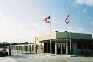
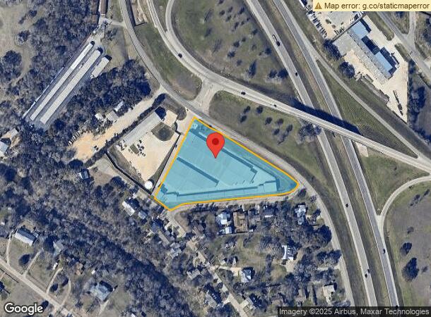
38835 Interstate 10 W
San Antonio-New Braunfels, TX
Cibolo Oaks Subdivision
39174
CIBOLO OAKS SUBDIVISION LOT 102A (REPLAT), 3.515 ACRES
Commercialbuilding
Kendall
X
Texas
48259C0400G
102a
2023
3.52 AC
2024
Kendall County
970302
San Antonio
77,640 SF
DEMOGRAPHICS near 38835 Interstate 10 W
1 Mile
3 Mile
5 Mile
2024 Total Population
1,364
13,944
29,775
2029 Population
1,687
17,382
37,268
Pop Growth 2024-2029
+ 23.68%
+ 24.66%
+ 25.17%
Average Age
46
43
42
2024 Total Households
539
5,466
11,131
HH Growth 2024-2029
+ 24.12%
+ 25.08%
+ 25.59%
Median Household Inc
$107,632
$89,270
$94,415
Avg Household Size
2.50
2.50
2.60
2024 Avg HH Vehicles
2.00
2.00
2.00
Median Home Value
$392,792
$374,702
$395,739
Median Year Built
1993
1999
2002
Nearby Places
- Restaurants
- Banks
- Shops
- Fitness
- Groceries
PUBLIC TRANSPORTATION
AIRPORT
San Antonio International
DRIVE
WALK
Distance
San Antonio International
37 min
31.6 mi
Freight Ports
Calhoun Port
DRIVE
WALK
Distance
Calhoun Port
216 min
183.2 mi
Nearby Properties
Address
Land Use
TOTAL SIZE
Lot Size
Zoning
Address
Land Use
TOTAL SIZE
Lot Size
Zoning
1,158,485 SF
11.76 AC
Address
Land Use
TOTAL SIZE
Lot Size
Zoning
86,050 SF
39.53 AC
Address
Land Use
TOTAL SIZE
Lot Size
Zoning
135,904 SF
10.40 AC
Address
Land Use
TOTAL SIZE
Lot Size
Zoning
78,586 SF
15.36 AC
Address
Land Use
TOTAL SIZE
Lot Size
Zoning
111,517 SF
20.86 AC
Address
Land Use
TOTAL SIZE
Lot Size
Zoning
90,958 SF
19.64 AC
Address
Land Use
TOTAL SIZE
Lot Size
Zoning
4,080 SF
302.27 AC
Address
Land Use
TOTAL SIZE
Lot Size
Zoning
43,470 SF
1.77 AC
Address
Land Use
TOTAL SIZE
Lot Size
Zoning
80,546 SF
4.66 AC
Address
Land Use
TOTAL SIZE
Lot Size
Zoning
1,924 SF
103.24 AC
Address
Land Use
TOTAL SIZE
Lot Size
Zoning
57,717 SF
3.78 AC
Address
Land Use
TOTAL SIZE
Lot Size
Zoning
86,137 SF
Address
Land Use
TOTAL SIZE
Lot Size
Zoning
119,256 SF
12.59 AC
Address
Land Use
TOTAL SIZE
Lot Size
Zoning
49,307 SF
1.07 AC
Address
Land Use
TOTAL SIZE
Lot Size
Zoning
139,865 SF
21.97 AC
Address
Land Use
TOTAL SIZE
Lot Size
Zoning
48,975 SF
2.98 AC
Address
Land Use
TOTAL SIZE
Lot Size
Zoning
26,100 SF
1.17 AC
Address
Land Use
TOTAL SIZE
Lot Size
Zoning
103,625 SF
4.88 AC
Address
Land Use
TOTAL SIZE
Lot Size
Zoning
89,570 SF
4.82 AC
Address
Land Use
TOTAL SIZE
Lot Size
Zoning
260 SF
64.67 AC
Address
Land Use
TOTAL SIZE
Lot Size
Zoning
78,410 SF
Address
Land Use
TOTAL SIZE
Lot Size
Zoning
31,678 SF
30 AC
Address
Land Use
TOTAL SIZE
Lot Size
Zoning
43,452 SF
3.32 AC
Address
Land Use
TOTAL SIZE
Lot Size
Zoning
90,229 SF
13.38 AC
Address
Land Use
TOTAL SIZE
Lot Size
Zoning
68,889 SF
2.16 AC
Address
Land Use
TOTAL SIZE
Lot Size
Zoning
14,144 SF
12.25 AC
Address
Land Use
TOTAL SIZE
Lot Size
Zoning
38,323 SF
3 AC
Address
Land Use
TOTAL SIZE
Lot Size
Zoning
22,637 SF
3.34 AC
Address
Land Use
TOTAL SIZE
Lot Size
Zoning
17,579 SF
0.96 AC
Address
Land Use
TOTAL SIZE
Lot Size
Zoning
44,943 SF
11.58 AC
The World's #1 Commercial Real Estate Marketplace
Connect with us
© 2025 CoStar Group
The information above has been obtained from sources believed reliable. While we do not doubt its accuracy we have not verified it and make no guarantee, warranty or representation about it. It is your responsibility to independently confirm its accuracy and completeness. Any projections, opinions, assumptions, or estimates used are for example only and do not represent the current or future performance of the property. The value of this transaction to you depends on tax and other factors which should be evaluated by your tax, financial, and legal advisors. You and your advisors should conduct a careful, independent investigation of the property to determine to your satisfaction the suitability of the property for your needs.