No Photo
Property Record
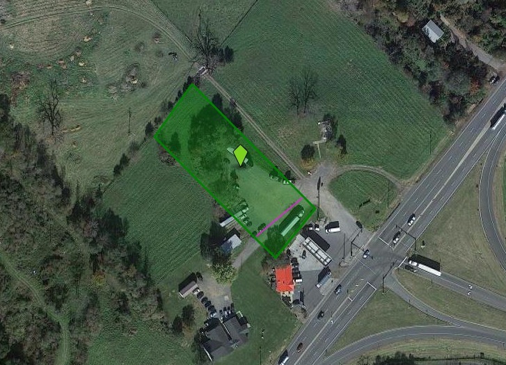
3891 N Valley Pike, Rockingham, VA 22802
NEARBY LISTINGS FOR SALE OR LEASE
Property Detail
3891 N Valley Pike
95-A-L60C
Valley Pike
Commercialacreage
Rockingham
X
Virginia
51165C0402D
3.46 AC
2024
Staunton & Harrisonburg
2024
Other Market Areas
010600
Harrisonburg, VA
DEMOGRAPHICS near 3891 N Valley Pike
1 Mile
3 Mile
5 Mile
2024 Total Population
1,213
10,903
45,678
2029 Population
1,264
10,889
45,280
Pop Growth 2024-2029
+ 4.20%
(0.13%)
(0.87%)
Average Age
37
35
33
2024 Total Households
458
4,007
14,921
HH Growth 2024-2029
+ 4.15%
(0.20%)
(1.00%)
Median Household Inc
$47,338
$56,748
$54,619
Avg Household Size
2.60
2.70
2.50
2024 Avg HH Vehicles
2.00
2.00
2.00
Median Home Value
$85,029
$199,999
$253,776
Median Year Built
1977
1985
1984
Nearby Places
- Restaurants
- Banks
- Shops
- Fitness
- Groceries
SALE & LEASE HISTORY
LISTING DATE
SALE/LEASE

Sep 05, 2023
For Sale
Nearby Properties
Address
Land Use
TOTAL SIZE
Lot Size
Zoning
Address
Land Use
TOTAL SIZE
Lot Size
Zoning
5,000 SF
12.96 AC
GENERAL IN
Address
Land Use
TOTAL SIZE
Lot Size
Zoning
138.58 AC
GEN INDUST
Address
Land Use
TOTAL SIZE
Lot Size
Zoning
16,758 SF
131 SF
MULTI DWEL
Address
Land Use
TOTAL SIZE
Lot Size
Zoning
MULTI DWEL
Address
Land Use
TOTAL SIZE
Lot Size
Zoning
81.38 AC
GEN INDUST
Address
Land Use
TOTAL SIZE
Lot Size
Zoning
12,276 SF
87 SF
MULTI DWEL
Address
Land Use
TOTAL SIZE
Lot Size
Zoning
79,698 SF
36.51 AC
GENERAL IN
Address
Land Use
TOTAL SIZE
Lot Size
Zoning
6,784 SF
5.88 AC
GENERAL BU
Address
Land Use
TOTAL SIZE
Lot Size
Zoning
15 AC
GENERAL IN
Address
Land Use
TOTAL SIZE
Lot Size
Zoning
24.72 AC
GEN INDUST
Address
Land Use
TOTAL SIZE
Lot Size
Zoning
100 SF
45.22 AC
GENERAL BU
Address
Land Use
TOTAL SIZE
Lot Size
Zoning
151.95 AC
GENERAL IN
Address
Land Use
TOTAL SIZE
Lot Size
Zoning
13,200 SF
15 AC
RESIDENTIA
Address
Land Use
TOTAL SIZE
Lot Size
Zoning
25,211 SF
5 AC
GENERAL IN
Address
Land Use
TOTAL SIZE
Lot Size
Zoning
33,457 SF
3.24 AC
GENERAL IN
Address
Land Use
TOTAL SIZE
Lot Size
Zoning
41,758 SF
7.55 AC
GENERAL IN
Address
Land Use
TOTAL SIZE
Lot Size
Zoning
3,584 SF
87 SF
PLANNED UN
Address
Land Use
TOTAL SIZE
Lot Size
Zoning
39,986 SF
1.82 AC
GENERAL IN
Address
Land Use
TOTAL SIZE
Lot Size
Zoning
88,738 SF
10.61 AC
GENERAL IN
Address
Land Use
TOTAL SIZE
Lot Size
Zoning
12.08 AC
GENERAL BU
Address
Land Use
TOTAL SIZE
Lot Size
Zoning
37,331 SF
3.82 AC
GENERAL BU
Address
Land Use
TOTAL SIZE
Lot Size
Zoning
5,100 SF
8.02 AC
GENERAL IN
Address
Land Use
TOTAL SIZE
Lot Size
Zoning
12,984 SF
1.34 AC
RESIDENTIA
Address
Land Use
TOTAL SIZE
Lot Size
Zoning
49.56 AC
GEN AGRICU
Address
Land Use
TOTAL SIZE
Lot Size
Zoning
14,320 SF
87 SF
PLANNED UN
Address
Land Use
TOTAL SIZE
Lot Size
Zoning
14,320 SF
87 SF
PLANNED UN
Address
Land Use
TOTAL SIZE
Lot Size
Zoning
14.89 AC
GENERAL IN
Address
Land Use
TOTAL SIZE
Lot Size
Zoning
12.34 AC
GEN INDUST
Address
Land Use
TOTAL SIZE
Lot Size
Zoning
15,952 SF
2.61 AC
GENERAL BU
Address
Land Use
TOTAL SIZE
Lot Size
Zoning
10.04 AC
GEN AGRICU
The World's #1 Commercial Real Estate Marketplace
Connect with us
© 2025 CoStar Group
The information above has been obtained from sources believed reliable. While we do not doubt its accuracy we have not verified it and make no guarantee, warranty or representation about it. It is your responsibility to independently confirm its accuracy and completeness. Any projections, opinions, assumptions, or estimates used are for example only and do not represent the current or future performance of the property. The value of this transaction to you depends on tax and other factors which should be evaluated by your tax, financial, and legal advisors. You and your advisors should conduct a careful, independent investigation of the property to determine to your satisfaction the suitability of the property for your needs.