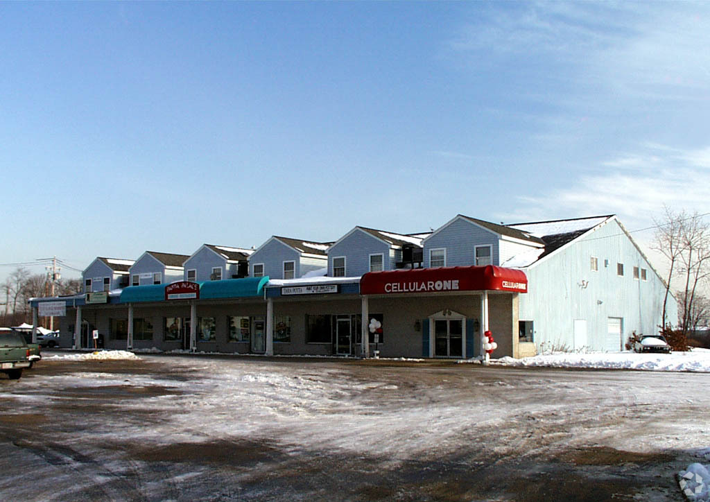
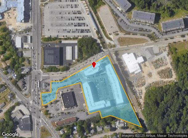
Property Record
29 Trotter Rd, South Weymouth, MA 02190


NEARBY LISTINGS FOR SALE OR LEASE
Property Detail
29 Trotter Rd
WEYM-000061-000627-000025
Norfolk
Commercialofficeresidentialmixeduse
Massachusetts
A
25
25023C0089K
5.56 AC
2021
Route 3 Corridor
2024
Boston
422201
Boston-Cambridge-Newton, MA-NH
40,396 SF
DEMOGRAPHICS near 29 Trotter Rd
1 Mile
3 Mile
5 Mile
2024 Total Population
6,454
52,320
173,649
2029 Population
6,528
52,238
173,032
Pop Growth 2024-2029
+ 1.15%
(0.16%)
(0.36%)
Average Age
41
42
42
2024 Total Households
2,869
21,442
66,498
HH Growth 2024-2029
+ 0.94%
(0.18%)
(0.39%)
Median Household Inc
$116,339
$102,909
$102,249
Avg Household Size
2.20
2.40
2.50
2024 Avg HH Vehicles
2.00
2.00
2.00
Median Home Value
$585,244
$467,922
$462,998
Median Year Built
1997
1966
1963
Nearby Places
- Restaurants
- Banks
- Shops
- Fitness
- Groceries
PUBLIC TRANSPORTATION
COMMUTER RAIL
South Weymouth (Kingston/Plymouth Line - Massachusetts Bay Transportation Authority Commuter Rail (Purple Line))
DRIVE
WALK
Distance
South Weymouth (Kingston/Plymouth Line - Massachusetts Bay Transportation Authority Commuter Rail (Purple Line))
0 min
2 min
0.1 mi
Abington (Kingston/Plymouth Line - Massachusetts Bay Transportation Authority Commuter Rail (Purple Line))
DRIVE
WALK
Distance
Abington (Kingston/Plymouth Line - Massachusetts Bay Transportation Authority Commuter Rail (Purple Line))
7 min
3.9 mi
AIRPORT
General Edward Lawrence Logan International
DRIVE
WALK
Distance
General Edward Lawrence Logan International
31 min
20.4 mi
Freight Ports
Port of Boston
DRIVE
WALK
Distance
Port of Boston
29 min
18.2 mi
Nearby Properties
Address
Land Use
TOTAL SIZE
Lot Size
Zoning
Address
Land Use
TOTAL SIZE
Lot Size
Zoning
48.16 AC
Address
Land Use
TOTAL SIZE
Lot Size
Zoning
31.29 AC
100
Address
Land Use
TOTAL SIZE
Lot Size
Zoning
Address
Land Use
TOTAL SIZE
Lot Size
Zoning
235,150 SF
36.67 AC
R1
Address
Land Use
TOTAL SIZE
Lot Size
Zoning
32.04 AC
Address
Land Use
TOTAL SIZE
Lot Size
Zoning
3.65 AC
100
Address
Land Use
TOTAL SIZE
Lot Size
Zoning
7.62 AC
A2
Address
Land Use
TOTAL SIZE
Lot Size
Zoning
19.08 AC
A1
Address
Land Use
TOTAL SIZE
Lot Size
Zoning
172,169 SF
1.64 AC
100
Address
Land Use
TOTAL SIZE
Lot Size
Zoning
36.20 AC
Address
Land Use
TOTAL SIZE
Lot Size
Zoning
8.54 AC
100
Address
Land Use
TOTAL SIZE
Lot Size
Zoning
144,377 SF
9.39 AC
Address
Land Use
TOTAL SIZE
Lot Size
Zoning
6.50 AC
A2
Address
Land Use
TOTAL SIZE
Lot Size
Zoning
147,069 SF
1.90 AC
Address
Land Use
TOTAL SIZE
Lot Size
Zoning
20.23 AC
Address
Land Use
TOTAL SIZE
Lot Size
Zoning
3.92 AC
R-4
Address
Land Use
TOTAL SIZE
Lot Size
Zoning
168,801 SF
2.75 AC
100
Address
Land Use
TOTAL SIZE
Lot Size
Zoning
34.28 AC
85
Address
Land Use
TOTAL SIZE
Lot Size
Zoning
1.48 AC
100
Address
Land Use
TOTAL SIZE
Lot Size
Zoning
103,128 SF
13.02 AC
85
Address
Land Use
TOTAL SIZE
Lot Size
Zoning
3.72 AC
INDUST
Address
Land Use
TOTAL SIZE
Lot Size
Zoning
74,600 SF
6.29 AC
Address
Land Use
TOTAL SIZE
Lot Size
Zoning
85,338 SF
1.85 AC
Address
Land Use
TOTAL SIZE
Lot Size
Zoning
237,417 SF
13.60 AC
Address
Land Use
TOTAL SIZE
Lot Size
Zoning
162,931 SF
4.50 AC
INDUST
Address
Land Use
TOTAL SIZE
Lot Size
Zoning
14.52 AC
Address
Land Use
TOTAL SIZE
Lot Size
Zoning
5.86 AC
R-4
Address
Land Use
TOTAL SIZE
Lot Size
Zoning
79,227 SF
3.58 AC
85
Address
Land Use
TOTAL SIZE
Lot Size
Zoning
204,293 SF
8.50 AC
INDUST
The World's #1 Commercial Real Estate Marketplace
Connect with us
© 2025 CoStar Group
The information above has been obtained from sources believed reliable. While we do not doubt its accuracy we have not verified it and make no guarantee, warranty or representation about it. It is your responsibility to independently confirm its accuracy and completeness. Any projections, opinions, assumptions, or estimates used are for example only and do not represent the current or future performance of the property. The value of this transaction to you depends on tax and other factors which should be evaluated by your tax, financial, and legal advisors. You and your advisors should conduct a careful, independent investigation of the property to determine to your satisfaction the suitability of the property for your needs.