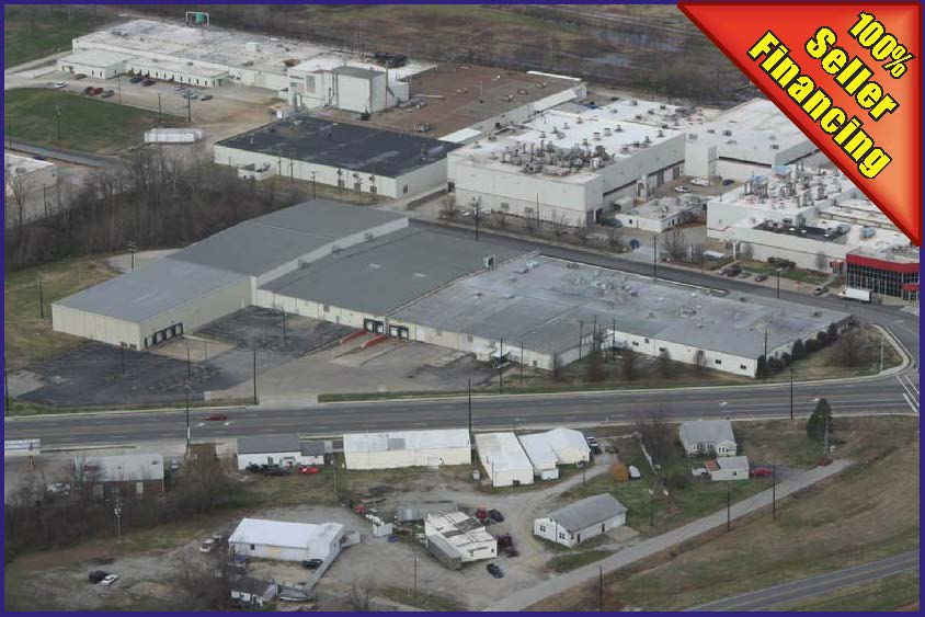
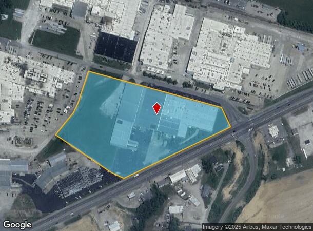
Property Record
390 Community Dr, Henderson, KY 42420
NEARBY LISTINGS FOR SALE OR LEASE
-
-
View all Henderson listings for lease on LoopNet.com
Property Detail
390 Community Dr
Evansville, IN-KY
Industrial Foundation Pa
39B-1
MANUFACTURING
Manufacturinglight
Henderson
X
Kentucky
21101C0217F
3&3a
2024
8.12 AC
2024
Henderson County
020902
Evansville
4,860 SF
DEMOGRAPHICS near 390 Community Dr
1 Mile
3 Mile
5 Mile
2024 Total Population
740
6,354
19,798
2029 Population
715
6,248
19,493
Pop Growth 2024-2029
(3.38%)
(1.67%)
(1.54%)
Average Age
41
40
40
2024 Total Households
297
2,464
8,084
HH Growth 2024-2029
(3.70%)
(1.70%)
(1.62%)
Median Household Inc
$51,000
$59,024
$45,328
Avg Household Size
2.50
2.30
2.30
2024 Avg HH Vehicles
2.00
2.00
2.00
Median Home Value
$128,571
$133,708
$121,331
Median Year Built
1975
1971
1967
Nearby Places
- Restaurants
- Banks
- Shops
- Fitness
- Groceries
PUBLIC TRANSPORTATION
AIRPORT
Evansville Regional
DRIVE
WALK
Distance
Evansville Regional
34 min
18.8 mi
Freight Ports
Port of Toledo
DRIVE
WALK
Distance
Port of Toledo
479 min
408.5 mi
SALE & LEASE HISTORY
LISTING DATE
SALE/LEASE

Sep 25, 2016
For Lease
Nearby Properties
Address
Land Use
TOTAL SIZE
Lot Size
Zoning
Address
Land Use
TOTAL SIZE
Lot Size
Zoning
1,338 SF
401.60 AC
Address
Land Use
TOTAL SIZE
Lot Size
Zoning
11.19 AC
Address
Land Use
TOTAL SIZE
Lot Size
Zoning
50,469 SF
30.33 AC
Address
Land Use
TOTAL SIZE
Lot Size
Zoning
404,305 SF
76.76 AC
Address
Land Use
TOTAL SIZE
Lot Size
Zoning
4.90 AC
Address
Land Use
TOTAL SIZE
Lot Size
Zoning
61.91 AC
COMMERCIAL
Address
Land Use
TOTAL SIZE
Lot Size
Zoning
31,800 SF
92.72 AC
Address
Land Use
TOTAL SIZE
Lot Size
Zoning
Address
Land Use
TOTAL SIZE
Lot Size
Zoning
Address
Land Use
TOTAL SIZE
Lot Size
Zoning
175,156 SF
48.43 AC
Address
Land Use
TOTAL SIZE
Lot Size
Zoning
19.48 AC
COMMERCIAL
Address
Land Use
TOTAL SIZE
Lot Size
Zoning
Address
Land Use
TOTAL SIZE
Lot Size
Zoning
7,600 SF
13.85 AC
Address
Land Use
TOTAL SIZE
Lot Size
Zoning
2,500 SF
189.30 AC
Address
Land Use
TOTAL SIZE
Lot Size
Zoning
15 AC
COMMERCIAL
Address
Land Use
TOTAL SIZE
Lot Size
Zoning
70,858 SF
9 AC
Address
Land Use
TOTAL SIZE
Lot Size
Zoning
45.67 AC
Address
Land Use
TOTAL SIZE
Lot Size
Zoning
193,120 SF
11.37 AC
Address
Land Use
TOTAL SIZE
Lot Size
Zoning
21.28 AC
Address
Land Use
TOTAL SIZE
Lot Size
Zoning
20,000 SF
6 AC
COMMERCIAL
Address
Land Use
TOTAL SIZE
Lot Size
Zoning
26.22 AC
Address
Land Use
TOTAL SIZE
Lot Size
Zoning
82,822 SF
8 AC
Address
Land Use
TOTAL SIZE
Lot Size
Zoning
528 SF
130.97 AC
Address
Land Use
TOTAL SIZE
Lot Size
Zoning
6.43 AC
Address
Land Use
TOTAL SIZE
Lot Size
Zoning
Address
Land Use
TOTAL SIZE
Lot Size
Zoning
155,312 SF
11.54 AC
Address
Land Use
TOTAL SIZE
Lot Size
Zoning
89,700 SF
8.38 AC
Address
Land Use
TOTAL SIZE
Lot Size
Zoning
157,500 SF
25 AC
Address
Land Use
TOTAL SIZE
Lot Size
Zoning
51,840 SF
17.49 AC
Address
Land Use
TOTAL SIZE
Lot Size
Zoning
44,712 SF
7.54 AC
The World's #1 Commercial Real Estate Marketplace
Connect with us
© 2025 CoStar Group
The information above has been obtained from sources believed reliable. While we do not doubt its accuracy we have not verified it and make no guarantee, warranty or representation about it. It is your responsibility to independently confirm its accuracy and completeness. Any projections, opinions, assumptions, or estimates used are for example only and do not represent the current or future performance of the property. The value of this transaction to you depends on tax and other factors which should be evaluated by your tax, financial, and legal advisors. You and your advisors should conduct a careful, independent investigation of the property to determine to your satisfaction the suitability of the property for your needs.