Property Record
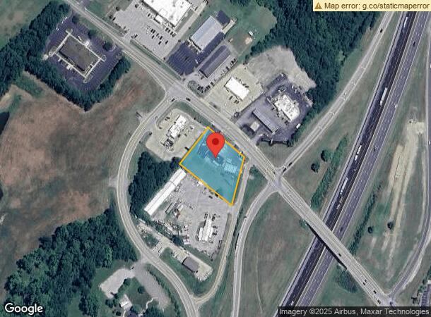
390 Violet Rd, Crittenden, KY 41030
NEARBY LISTINGS FOR SALE OR LEASE
-
-
View all Crittenden listings for sale on LoopNet.com
Property Detail
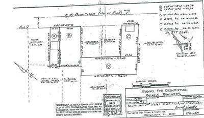
390 Violet Rd
042-00-00-042.00
GAS STATION-CHEVRON & 0.92 AC
Servicestation
Grant
X
Kentucky
21015C0325D
0.92 AC
2024
Grant County
2024
Cincinnati/Dayton
920101
Cincinnati, OH-KY-IN
1,484 SF
DEMOGRAPHICS near 390 Violet Rd
1 Mile
3 Mile
5 Mile
2024 Total Population
2,553
7,543
14,201
2029 Population
2,654
7,900
14,854
Pop Growth 2024-2029
+ 3.96%
+ 4.73%
+ 4.60%
Average Age
38
38
38
2024 Total Households
968
2,672
5,007
HH Growth 2024-2029
+ 4.03%
+ 4.79%
+ 4.65%
Median Household Inc
$55,048
$75,073
$72,199
Avg Household Size
2.70
2.80
2.80
2024 Avg HH Vehicles
2.00
2.00
2.00
Median Home Value
$238,016
$204,271
$203,035
Median Year Built
1994
1995
1994
Nearby Places
- Restaurants
- Banks
- Shops
- Fitness
- Groceries
PUBLIC TRANSPORTATION
AIRPORT
Cincinnati/Northern Kentucky International
DRIVE
WALK
Distance
Cincinnati/Northern Kentucky International
31 min
20.6 mi
Freight Ports
Port of Toledo
DRIVE
WALK
Distance
Port of Toledo
273 min
232.6 mi
Nearby Properties
Address
Land Use
TOTAL SIZE
Lot Size
Zoning
Address
Land Use
TOTAL SIZE
Lot Size
Zoning
4,736 SF
0.50 AC
Address
Land Use
TOTAL SIZE
Lot Size
Zoning
39,000 SF
5.97 AC
Address
Land Use
TOTAL SIZE
Lot Size
Zoning
1,680 SF
65.43 AC
Address
Land Use
TOTAL SIZE
Lot Size
Zoning
1,745 SF
282.88 AC
Address
Land Use
TOTAL SIZE
Lot Size
Zoning
66.39 AC
Address
Land Use
TOTAL SIZE
Lot Size
Zoning
20,000 SF
5 AC
Address
Land Use
TOTAL SIZE
Lot Size
Zoning
3.88 AC
Address
Land Use
TOTAL SIZE
Lot Size
Zoning
2,032 SF
28.30 AC
Address
Land Use
TOTAL SIZE
Lot Size
Zoning
5,760 SF
0.76 AC
Address
Land Use
TOTAL SIZE
Lot Size
Zoning
11,787 SF
2.33 AC
Address
Land Use
TOTAL SIZE
Lot Size
Zoning
13.50 AC
Address
Land Use
TOTAL SIZE
Lot Size
Zoning
1,680 SF
44.58 AC
Address
Land Use
TOTAL SIZE
Lot Size
Zoning
114.02 AC
Address
Land Use
TOTAL SIZE
Lot Size
Zoning
14,912 SF
3 AC
Address
Land Use
TOTAL SIZE
Lot Size
Zoning
1.94 AC
Address
Land Use
TOTAL SIZE
Lot Size
Zoning
2,304 SF
217.90 AC
Address
Land Use
TOTAL SIZE
Lot Size
Zoning
8,064 SF
2.20 AC
Address
Land Use
TOTAL SIZE
Lot Size
Zoning
6.40 AC
Address
Land Use
TOTAL SIZE
Lot Size
Zoning
68.91 AC
Address
Land Use
TOTAL SIZE
Lot Size
Zoning
0.95 AC
Address
Land Use
TOTAL SIZE
Lot Size
Zoning
1,728 SF
12.16 AC
Address
Land Use
TOTAL SIZE
Lot Size
Zoning
20,000 SF
39.26 AC
Address
Land Use
TOTAL SIZE
Lot Size
Zoning
183.32 AC
Address
Land Use
TOTAL SIZE
Lot Size
Zoning
Address
Land Use
TOTAL SIZE
Lot Size
Zoning
5,218 SF
1.15 AC
Address
Land Use
TOTAL SIZE
Lot Size
Zoning
3,545 SF
10.92 AC
Address
Land Use
TOTAL SIZE
Lot Size
Zoning
1.63 AC
Address
Land Use
TOTAL SIZE
Lot Size
Zoning
4,048 SF
1.07 AC
Address
Land Use
TOTAL SIZE
Lot Size
Zoning
1,680 SF
80.62 AC
Address
Land Use
TOTAL SIZE
Lot Size
Zoning
9,448 SF
2.59 AC
The World's #1 Commercial Real Estate Marketplace
Connect with us
© 2025 CoStar Group
The information above has been obtained from sources believed reliable. While we do not doubt its accuracy we have not verified it and make no guarantee, warranty or representation about it. It is your responsibility to independently confirm its accuracy and completeness. Any projections, opinions, assumptions, or estimates used are for example only and do not represent the current or future performance of the property. The value of this transaction to you depends on tax and other factors which should be evaluated by your tax, financial, and legal advisors. You and your advisors should conduct a careful, independent investigation of the property to determine to your satisfaction the suitability of the property for your needs.