Property Record
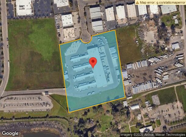
3930 Kristi Ct, Sacramento, CA 95827
NEARBY LISTINGS FOR SALE OR LEASE
Property Detail
3930 Kristi Ct
Sacramento--Roseville--Arden-Arcade, CA
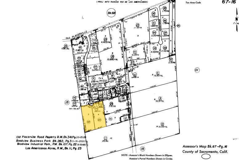
Of Bradview Business Park
067-0160-098
LOTS 3&4 OF BRADVIEW BUSINESS PARK RM282-003.
Transportnec
Sacramento
X
California
06067C0215H
3,4
2023
9.07 AC
2024
Highway 50 Corridor
009005
Sacramento
53,366 SF
DEMOGRAPHICS near 3930 Kristi Ct
1 Mile
3 Mile
5 Mile
2024 Total Population
7,588
76,111
196,798
2029 Population
7,602
76,583
198,350
Pop Growth 2024-2029
+ 0.18%
+ 0.62%
+ 0.79%
Average Age
38
38
39
2024 Total Households
2,692
28,152
75,045
HH Growth 2024-2029
+ 0.15%
+ 0.64%
+ 0.81%
Median Household Inc
$74,180
$79,875
$79,969
Avg Household Size
2.80
2.60
2.50
2024 Avg HH Vehicles
2.00
2.00
2.00
Median Home Value
$345,148
$409,524
$457,029
Median Year Built
1976
1975
1974
Nearby Places
- Restaurants
- Banks
- Shops
- Fitness
- Groceries
PUBLIC TRANSPORTATION
AIRPORT
Sacramento International
DRIVE
WALK
Distance
Sacramento International
33 min
23.5 mi
Freight Ports
Port of Stockton
DRIVE
WALK
Distance
Port of Stockton
65 min
49.0 mi
Nearby Properties
Address
Land Use
TOTAL SIZE
Lot Size
Zoning
Address
Land Use
TOTAL SIZE
Lot Size
Zoning
266,841 SF
47.29 AC
RD-5
Address
Land Use
TOTAL SIZE
Lot Size
Zoning
223,046 SF
10.99 AC
RD 20
Address
Land Use
TOTAL SIZE
Lot Size
Zoning
198,131 SF
13.36 AC
BP
Address
Land Use
TOTAL SIZE
Lot Size
Zoning
109,805 SF
20.04 AC
OPMU
Address
Land Use
TOTAL SIZE
Lot Size
Zoning
181,573 SF
12.10 AC
SPA (MFSPA
Address
Land Use
TOTAL SIZE
Lot Size
Zoning
162,023 SF
8.96 AC
OIMU
Address
Land Use
TOTAL SIZE
Lot Size
Zoning
0.21 AC
RD-5
Address
Land Use
TOTAL SIZE
Lot Size
Zoning
139,500 SF
5.21 AC
MP
Address
Land Use
TOTAL SIZE
Lot Size
Zoning
119,824 SF
7.64 AC
RD-30 (PC)
Address
Land Use
TOTAL SIZE
Lot Size
Zoning
221,337 SF
12.19 AC
RD 25
Address
Land Use
TOTAL SIZE
Lot Size
Zoning
135,375 SF
7.40 AC
RD-30
Address
Land Use
TOTAL SIZE
Lot Size
Zoning
132,149 SF
8.29 AC
OPMU
Address
Land Use
TOTAL SIZE
Lot Size
Zoning
95,174 SF
5.29 AC
SPA (MFSPA
Address
Land Use
TOTAL SIZE
Lot Size
Zoning
156,032 SF
9.31 AC
OPMU
Address
Land Use
TOTAL SIZE
Lot Size
Zoning
169,618 SF
10.44 AC
RD-4
Address
Land Use
TOTAL SIZE
Lot Size
Zoning
110,960 SF
6.62 AC
SPA (MFSPA
Address
Land Use
TOTAL SIZE
Lot Size
Zoning
198,413 SF
9.24 AC
RD 30
Address
Land Use
TOTAL SIZE
Lot Size
Zoning
148,650 SF
10.23 AC
OPMU
Address
Land Use
TOTAL SIZE
Lot Size
Zoning
12.47 AC
RD 30
Address
Land Use
TOTAL SIZE
Lot Size
Zoning
457,088 SF
12.50 AC
RD 30
Address
Land Use
TOTAL SIZE
Lot Size
Zoning
98,767 SF
6.43 AC
BP (ZSPA)
Address
Land Use
TOTAL SIZE
Lot Size
Zoning
302,966 SF
15.94 AC
RD 30
Address
Land Use
TOTAL SIZE
Lot Size
Zoning
258,819 SF
13.47 AC
RD 30
Address
Land Use
TOTAL SIZE
Lot Size
Zoning
8,724 SF
101.84 AC
M-2 (SM)
Address
Land Use
TOTAL SIZE
Lot Size
Zoning
184,249 SF
10.72 AC
OIMU (FBSP
Address
Land Use
TOTAL SIZE
Lot Size
Zoning
100,000 SF
7.03 AC
SPA (MFSPA
Address
Land Use
TOTAL SIZE
Lot Size
Zoning
107,817 SF
5.87 AC
OIMU (FBSP
Address
Land Use
TOTAL SIZE
Lot Size
Zoning
203,374 SF
12 AC
RD-20
Address
Land Use
TOTAL SIZE
Lot Size
Zoning
178,135 SF
1.06 AC
BP
Address
Land Use
TOTAL SIZE
Lot Size
Zoning
124,604 SF
8.50 AC
OPMU
The World's #1 Commercial Real Estate Marketplace
Connect with us
© 2025 CoStar Group
The information above has been obtained from sources believed reliable. While we do not doubt its accuracy we have not verified it and make no guarantee, warranty or representation about it. It is your responsibility to independently confirm its accuracy and completeness. Any projections, opinions, assumptions, or estimates used are for example only and do not represent the current or future performance of the property. The value of this transaction to you depends on tax and other factors which should be evaluated by your tax, financial, and legal advisors. You and your advisors should conduct a careful, independent investigation of the property to determine to your satisfaction the suitability of the property for your needs.