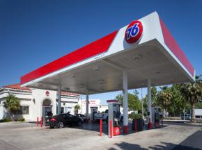
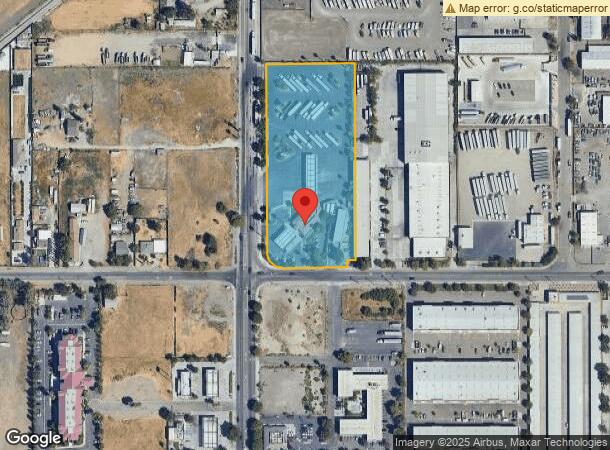
Property Record
3940 N Tracy Blvd, Tracy, CA 95304

NEARBY LISTINGS FOR SALE OR LEASE
Property Detail
3940 N Tracy Blvd
Stockton-Lodi, CA
Tracy Garden Farms
212-200-04
99-CONVEY 22140 SQ FT FOR ST WIDENING 98076889
Servicestationmarket
San Joaquin
AE
California
06077C0595F
8
2024
3.95 AC
2024
Tracy/Manteca
005225
Stockton/Modesto
4,367 SF
DEMOGRAPHICS near 3940 N Tracy Blvd
1 Mile
3 Mile
5 Mile
2024 Total Population
11,253
64,501
101,904
2029 Population
11,840
68,006
107,653
Pop Growth 2024-2029
+ 5.22%
+ 5.43%
+ 5.64%
Average Age
37
37
37
2024 Total Households
3,488
19,480
30,422
HH Growth 2024-2029
+ 5.28%
+ 5.45%
+ 5.66%
Median Household Inc
$80,266
$99,137
$110,049
Avg Household Size
3.10
3.20
3.30
2024 Avg HH Vehicles
2.00
2.00
3.00
Median Home Value
$467,462
$559,025
$637,873
Median Year Built
1982
1989
1994
Nearby Places
- Restaurants
- Banks
- Shops
- Fitness
- Groceries
PUBLIC TRANSPORTATION
COMMUTER RAIL
Tracy (Altamont Corridor Express - Altamont Commuter Express (ACE))
DRIVE
WALK
Distance
Tracy (Altamont Corridor Express - Altamont Commuter Express (ACE))
8 min
4.9 mi
AIRPORT
Stockton Metro
DRIVE
WALK
Distance
Stockton Metro
24 min
18.5 mi
Freight Ports
Port of Stockton
DRIVE
WALK
Distance
Port of Stockton
27 min
21.8 mi
Nearby Properties
Address
Land Use
TOTAL SIZE
Lot Size
Zoning
Address
Land Use
TOTAL SIZE
Lot Size
Zoning
3,485,402 SF
86.48 AC
Address
Land Use
TOTAL SIZE
Lot Size
Zoning
610,914 SF
28.11 AC
M1
Address
Land Use
TOTAL SIZE
Lot Size
Zoning
8.90 AC
Address
Land Use
TOTAL SIZE
Lot Size
Zoning
925,475 SF
42.09 AC
Address
Land Use
TOTAL SIZE
Lot Size
Zoning
1,601 SF
17.08 AC
PUD1
Address
Land Use
TOTAL SIZE
Lot Size
Zoning
657,600 SF
44.03 AC
Address
Land Use
TOTAL SIZE
Lot Size
Zoning
3.77 AC
Address
Land Use
TOTAL SIZE
Lot Size
Zoning
1,124,201 SF
53.72 AC
Address
Land Use
TOTAL SIZE
Lot Size
Zoning
795,732 SF
36.67 AC
IG
Address
Land Use
TOTAL SIZE
Lot Size
Zoning
749,840 SF
37.96 AC
Address
Land Use
TOTAL SIZE
Lot Size
Zoning
10.15 AC
PUD1
Address
Land Use
TOTAL SIZE
Lot Size
Zoning
24.07 AC
Address
Land Use
TOTAL SIZE
Lot Size
Zoning
567,870 SF
36.41 AC
M1
Address
Land Use
TOTAL SIZE
Lot Size
Zoning
461,810 SF
23.23 AC
PUD3
Address
Land Use
TOTAL SIZE
Lot Size
Zoning
36.18 AC
Address
Land Use
TOTAL SIZE
Lot Size
Zoning
223,849 SF
12.06 AC
Address
Land Use
TOTAL SIZE
Lot Size
Zoning
381,600 SF
19.46 AC
Address
Land Use
TOTAL SIZE
Lot Size
Zoning
22,726 SF
8.96 AC
PUD1
Address
Land Use
TOTAL SIZE
Lot Size
Zoning
19.39 AC
Address
Land Use
TOTAL SIZE
Lot Size
Zoning
442,350 SF
27.01 AC
CN
Address
Land Use
TOTAL SIZE
Lot Size
Zoning
532,500 SF
25.15 AC
Address
Land Use
TOTAL SIZE
Lot Size
Zoning
263,287 SF
11.99 AC
Address
Land Use
TOTAL SIZE
Lot Size
Zoning
265,000 SF
10.83 AC
Address
Land Use
TOTAL SIZE
Lot Size
Zoning
Address
Land Use
TOTAL SIZE
Lot Size
Zoning
16.37 AC
Address
Land Use
TOTAL SIZE
Lot Size
Zoning
126,204 SF
110.07 AC
Address
Land Use
TOTAL SIZE
Lot Size
Zoning
12.93 AC
The World's #1 Commercial Real Estate Marketplace
Connect with us
© 2025 CoStar Group
The information above has been obtained from sources believed reliable. While we do not doubt its accuracy we have not verified it and make no guarantee, warranty or representation about it. It is your responsibility to independently confirm its accuracy and completeness. Any projections, opinions, assumptions, or estimates used are for example only and do not represent the current or future performance of the property. The value of this transaction to you depends on tax and other factors which should be evaluated by your tax, financial, and legal advisors. You and your advisors should conduct a careful, independent investigation of the property to determine to your satisfaction the suitability of the property for your needs.