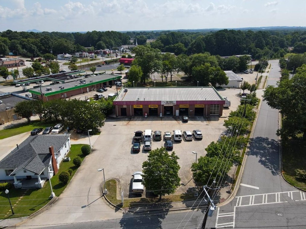
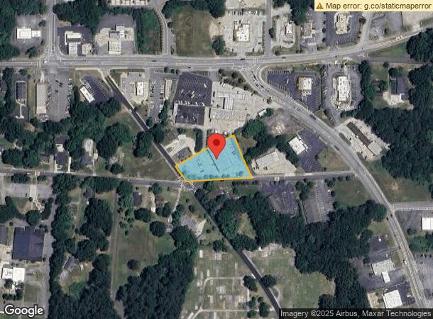
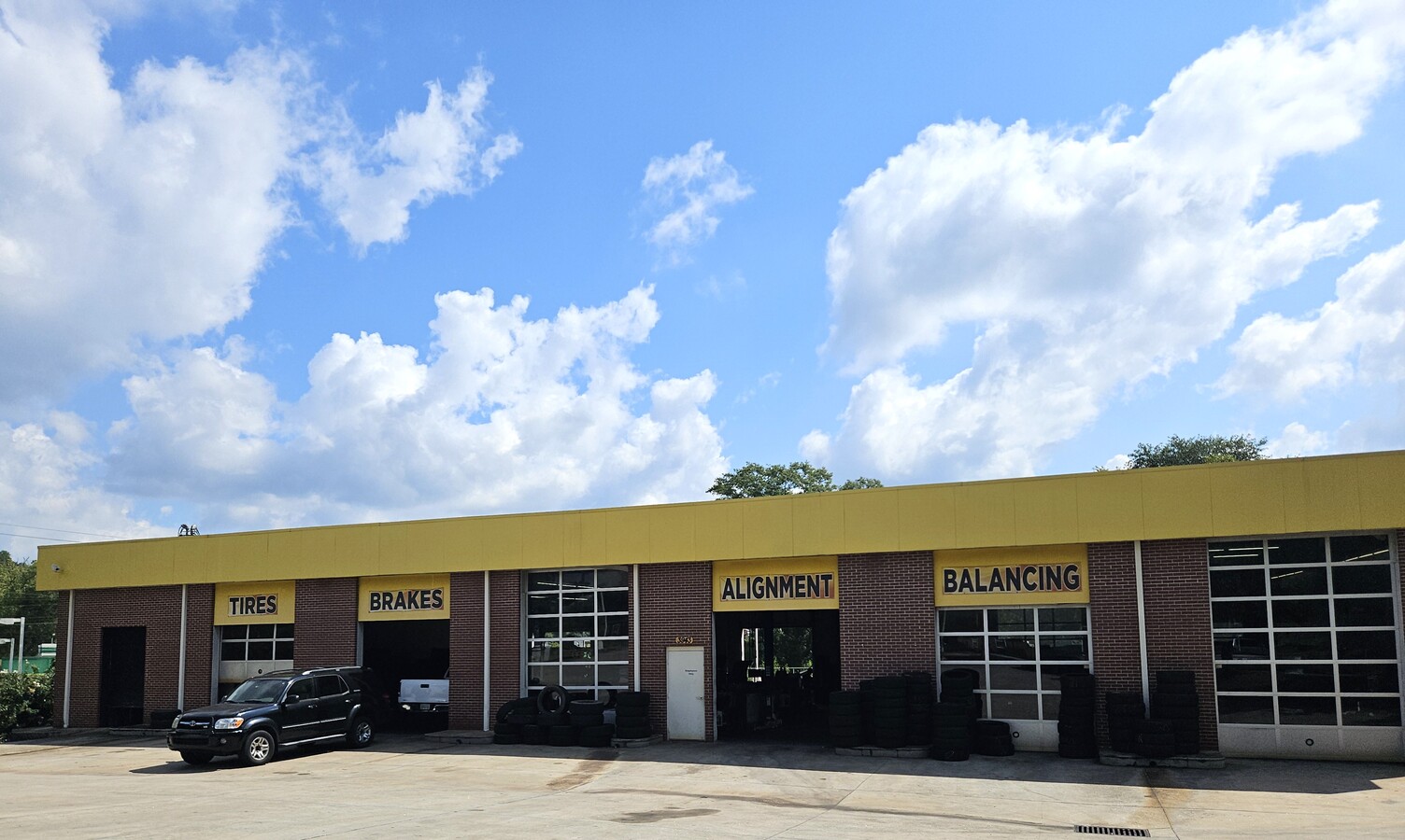
Property Record
3943 Old Austell Rd, Powder Springs, GA 30127
NEARBY LISTINGS FOR SALE OR LEASE
Property Detail
3943 Old Austell Rd
Atlanta-Sandy Springs-Roswell, GA
Wayne & Pat Llc
19-0904-0-048-0
ALL THAT TRACT OR PARCEL OF LAND LYING AND BEING IN THE 19TH DISTRICT, 2ND SECTION, COBB COUNTY, GEORGIA, LYING WITHIN LAND LOT 904, IDENTIFIED AS TAX PARCEL 48, ON THE FIELD MAP
Autorepair
Cobb
X
Georgia
13067C0181H
904
2024
0.99 AC
2024
Powder Spring/Austell
031513
Atlanta
7,259 SF
DEMOGRAPHICS near 3943 Old Austell Rd
1 Mile
3 Mile
5 Mile
2024 Total Population
6,105
44,639
120,552
2029 Population
6,258
45,513
124,071
Pop Growth 2024-2029
+ 2.51%
+ 1.96%
+ 2.92%
Average Age
41
39
39
2024 Total Households
2,176
15,121
42,348
HH Growth 2024-2029
+ 2.48%
+ 1.93%
+ 2.97%
Median Household Inc
$80,542
$83,805
$78,893
Avg Household Size
2.70
2.90
2.80
2024 Avg HH Vehicles
2.00
2.00
2.00
Median Home Value
$207,348
$261,879
$259,370
Median Year Built
1990
1993
1990
Nearby Places
- Restaurants
- Banks
- Shops
- Fitness
- Groceries
PUBLIC TRANSPORTATION
AIRPORT
Hartsfield - Jackson Atlanta International
DRIVE
WALK
Distance
Hartsfield - Jackson Atlanta International
45 min
29.9 mi
Freight Ports
Georgia Ports - Savannah
DRIVE
WALK
Distance
Georgia Ports - Savannah
308 min
269.2 mi
SALE & LEASE HISTORY
LISTING DATE
SALE/LEASE

Nov 30, 2016
For Sale
Jan 15, 2020
For Sale
Apr 08, 2021
For Sale
Apr 08, 2021
For Lease
Nearby Properties
Address
Land Use
TOTAL SIZE
Lot Size
Zoning
Address
Land Use
TOTAL SIZE
Lot Size
Zoning
18.80 AC
MXU
Address
Land Use
TOTAL SIZE
Lot Size
Zoning
171,510 SF
7.63 AC
MXU
Address
Land Use
TOTAL SIZE
Lot Size
Zoning
Address
Land Use
TOTAL SIZE
Lot Size
Zoning
350,000 SF
24 AC
HI
Address
Land Use
TOTAL SIZE
Lot Size
Zoning
170,892 SF
29.16 AC
CRC/LRO
Address
Land Use
TOTAL SIZE
Lot Size
Zoning
78.60 AC
R20
Address
Land Use
TOTAL SIZE
Lot Size
Zoning
67,341 SF
9.07 AC
GC
Address
Land Use
TOTAL SIZE
Lot Size
Zoning
79,348 SF
12.04 AC
CRC
Address
Land Use
TOTAL SIZE
Lot Size
Zoning
101,340 SF
4.24 AC
CRC
Address
Land Use
TOTAL SIZE
Lot Size
Zoning
38,418 SF
2.27 AC
GC
Address
Land Use
TOTAL SIZE
Lot Size
Zoning
110,040 SF
3.85 AC
LI
Address
Land Use
TOTAL SIZE
Lot Size
Zoning
104,746 SF
16.19 AC
CRC/LRO
Address
Land Use
TOTAL SIZE
Lot Size
Zoning
12.01 AC
CRC
Address
Land Use
TOTAL SIZE
Lot Size
Zoning
12,374 SF
1.42 AC
CBD
Address
Land Use
TOTAL SIZE
Lot Size
Zoning
98,851 SF
5.49 AC
LI
Address
Land Use
TOTAL SIZE
Lot Size
Zoning
367,298 SF
15.38 AC
LI
Address
Land Use
TOTAL SIZE
Lot Size
Zoning
116,104 SF
19 AC
GC/LI
Address
Land Use
TOTAL SIZE
Lot Size
Zoning
88,560 SF
13.80 AC
CRC/WS
Address
Land Use
TOTAL SIZE
Lot Size
Zoning
72,580 SF
7.05 AC
LI
Address
Land Use
TOTAL SIZE
Lot Size
Zoning
56,140 SF
8.24 AC
CRC
Address
Land Use
TOTAL SIZE
Lot Size
Zoning
80,572 SF
8.39 AC
GC
Address
Land Use
TOTAL SIZE
Lot Size
Zoning
9,882 SF
4.61 AC
CBD
Address
Land Use
TOTAL SIZE
Lot Size
Zoning
67,875 SF
1.91 AC
MXU
Address
Land Use
TOTAL SIZE
Lot Size
Zoning
Address
Land Use
TOTAL SIZE
Lot Size
Zoning
87,362 SF
20 AC
LI
Address
Land Use
TOTAL SIZE
Lot Size
Zoning
25,540 SF
5.50 AC
CRC/LI
Address
Land Use
TOTAL SIZE
Lot Size
Zoning
50,272 SF
2.77 AC
CRC/LI
Address
Land Use
TOTAL SIZE
Lot Size
Zoning
73,314 SF
5.30 AC
CRC
Address
Land Use
TOTAL SIZE
Lot Size
Zoning
27,891 SF
5.08 AC
CRC
Address
Land Use
TOTAL SIZE
Lot Size
Zoning
13,590 SF
152.02 AC
R-20
The World's #1 Commercial Real Estate Marketplace
Connect with us
© 2025 CoStar Group
The information above has been obtained from sources believed reliable. While we do not doubt its accuracy we have not verified it and make no guarantee, warranty or representation about it. It is your responsibility to independently confirm its accuracy and completeness. Any projections, opinions, assumptions, or estimates used are for example only and do not represent the current or future performance of the property. The value of this transaction to you depends on tax and other factors which should be evaluated by your tax, financial, and legal advisors. You and your advisors should conduct a careful, independent investigation of the property to determine to your satisfaction the suitability of the property for your needs.