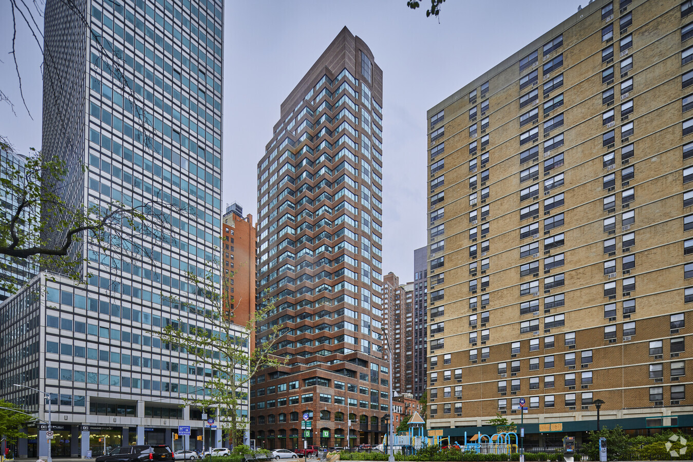
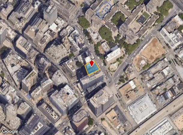
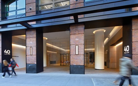
Property Record
40 Fulton St, New York, NY 10038

Current Lease Availabilities
NEARBY LISTINGS FOR SALE OR LEASE
Property Detail
40 Fulton St
0075-0021
Manhattan
Officebuilding
New York
AE
21
3604970184F
0.27 AC
2024
Insurance District
2024
New York City
001502
New York-Jersey City-White Plains, NY-NJ
234,553 SF
DEMOGRAPHICS near 40 Fulton St
1 Mile
3 Mile
5 Mile
2024 Total Population
131,344
1,009,237
2,487,960
2029 Population
122,021
957,620
2,353,612
Pop Growth 2024-2029
(7.10%)
(5.11%)
(5.40%)
Average Age
40
38
38
2024 Total Households
59,981
469,832
1,091,557
HH Growth 2024-2029
(7.36%)
(5.51%)
(5.74%)
Median Household Inc
$125,498
$112,214
$93,927
Avg Household Size
2.00
2.00
2.20
2024 Avg HH Vehicles
.00
.00
.00
Median Home Value
$1,047,098
$981,721
$922,887
Median Year Built
1956
1955
1954
Nearby Places
- Restaurants
- Banks
- Shops
- Fitness
- Groceries
PUBLIC TRANSPORTATION
TRANSIT/SUBWAY
Fulton Street (2,3 Line) (2 - New York MTA Subway (The Subway), 3 - New York MTA Subway (The Subway))
Drive
Walk
Distance
Fulton Street (2,3 Line) (2 - New York MTA Subway (The Subway), 3 - New York MTA Subway (The Subway))
1 min
3 min
0.2 mi
Fulton Street (J,M,Z Line) (J - New York MTA Subway (The Subway), M - New York MTA Subway (The Subway), Z - New York MTA Subway (The Subway))
Drive
Walk
Distance
Fulton Street (J,M,Z Line) (J - New York MTA Subway (The Subway), M - New York MTA Subway (The Subway), Z - New York MTA Subway (The Subway))
1 min
4 min
0.3 mi
Broadway-Nassau Street (A - New York MTA Subway (The Subway), C - New York MTA Subway (The Subway))
Drive
Walk
Distance
Broadway-Nassau Street (A - New York MTA Subway (The Subway), C - New York MTA Subway (The Subway))
1 min
5 min
0.3 mi
Wall Street (2,3 Line) (2 - New York MTA Subway (The Subway), 3 - New York MTA Subway (The Subway))
Drive
Walk
Distance
Wall Street (2,3 Line) (2 - New York MTA Subway (The Subway), 3 - New York MTA Subway (The Subway))
1 min
6 min
0.3 mi
Fulton Street (4,5 Line) (4 - New York MTA Subway (The Subway), 5 - New York MTA Subway (The Subway))
Drive
Walk
Distance
Fulton Street (4,5 Line) (4 - New York MTA Subway (The Subway), 5 - New York MTA Subway (The Subway))
2 min
6 min
0.3 mi
COMMUTER RAIL
Christopher St (Hoboken-33rd Street - Port Authority Trans-Hudson (PATH), Journal Square-33rd Street - Port Authority Trans-Hudson (PATH))
Drive
Walk
Distance
Christopher St (Hoboken-33rd Street - Port Authority Trans-Hudson (PATH), Journal Square-33rd Street - Port Authority Trans-Hudson (PATH))
7 min
2.2 mi
Exchange Place (Hoboken-World Trade Center - Port Authority Trans-Hudson (PATH), Newark Penn Station-World Trade Center - Port Authority Trans-Hudson (PATH))
Drive
Walk
Distance
Exchange Place (Hoboken-World Trade Center - Port Authority Trans-Hudson (PATH), Newark Penn Station-World Trade Center - Port Authority Trans-Hudson (PATH))
14 min
4.9 mi
AIRPORT
Laguardia
Drive
Walk
Distance
Laguardia
22 min
10.4 mi
Newark Liberty International
Drive
Walk
Distance
Newark Liberty International
22 min
13.2 mi
John F Kennedy International
Drive
Walk
Distance
John F Kennedy International
32 min
18.6 mi
Freight Ports
NY - Red Hook Container Terminal
Drive
Walk
Distance
NY - Red Hook Container Terminal
8 min
3.4 mi
Nearby Properties
Address
Land Use
TOTAL SIZE
Lot Size
Zoning
Address
Land Use
TOTAL SIZE
Lot Size
Zoning
8966500
19.14 AC
C6-4
Address
Land Use
TOTAL SIZE
Lot Size
Zoning
8462176
61.41 AC
R7-2
Address
Land Use
TOTAL SIZE
Lot Size
Zoning
2161994
3.79 AC
M1-5
Address
Land Use
TOTAL SIZE
Lot Size
Zoning
2354289
3.96 AC
C6-4
Address
Land Use
TOTAL SIZE
Lot Size
Zoning
2812739
2.10 AC
C5-3
Address
Land Use
TOTAL SIZE
Lot Size
Zoning
1048620
5.67 AC
C6-4
Address
Land Use
TOTAL SIZE
Lot Size
Zoning
6877
27.74 AC
R-1E
Address
Land Use
TOTAL SIZE
Lot Size
Zoning
2.38 AC
Address
Land Use
TOTAL SIZE
Lot Size
Zoning
1.75 AC
Address
Land Use
TOTAL SIZE
Lot Size
Zoning
2157862
2.23 AC
BPC
Address
Land Use
TOTAL SIZE
Lot Size
Zoning
2255659
4.58 AC
BPC
Address
Land Use
TOTAL SIZE
Lot Size
Zoning
2124441
17.29 AC
R8
Address
Land Use
TOTAL SIZE
Lot Size
Zoning
2233692
1.90 AC
BPC
Address
Land Use
TOTAL SIZE
Lot Size
Zoning
882360
1.76 AC
C6-4
Address
Land Use
TOTAL SIZE
Lot Size
Zoning
2.21 AC
Address
Land Use
TOTAL SIZE
Lot Size
Zoning
1636000
1.08 AC
C6-4
Address
Land Use
TOTAL SIZE
Lot Size
Zoning
1104505
2.32 AC
C4-7
Address
Land Use
TOTAL SIZE
Lot Size
Zoning
1909502
2.37 AC
BPC
Address
Land Use
TOTAL SIZE
Lot Size
Zoning
1233394
1.78 AC
C5-3
Address
Land Use
TOTAL SIZE
Lot Size
Zoning
1100533
3.79 AC
M1-5
Address
Land Use
TOTAL SIZE
Lot Size
Zoning
940000
1.44 AC
C6-2
Address
Land Use
TOTAL SIZE
Lot Size
Zoning
1.04 AC
Address
Land Use
TOTAL SIZE
Lot Size
Zoning
1.84 AC
Address
Land Use
TOTAL SIZE
Lot Size
Zoning
1.87 AC
I-2
Address
Land Use
TOTAL SIZE
Lot Size
Zoning
7064736
147.61 AC
M3-1
Address
Land Use
TOTAL SIZE
Lot Size
Zoning
1560607
2.69 AC
C6-6
Address
Land Use
TOTAL SIZE
Lot Size
Zoning
2.43 AC
I-2
Address
Land Use
TOTAL SIZE
Lot Size
Zoning
1780030
5.07 AC
BPC
Address
Land Use
TOTAL SIZE
Lot Size
Zoning
11.15 AC
Address
Land Use
TOTAL SIZE
Lot Size
Zoning
512
1.30 AC
R1
Start a new search to find other properties for sale or lease
Connect with us
© 2024 CoStar Group
The information above has been obtained from sources believed reliable. While we do not doubt its accuracy we have not verified it and make no guarantee, warranty or representation about it. It is your responsibility to independently confirm its accuracy and completeness. Any projections, opinions, assumptions, or estimates used are for example only and do not represent the current or future performance of the property. The value of this transaction to you depends on tax and other factors which should be evaluated by your tax, financial, and legal advisors. You and your advisors should conduct a careful, independent investigation of the property to determine to your satisfaction the suitability of the property for your needs.