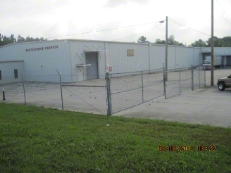
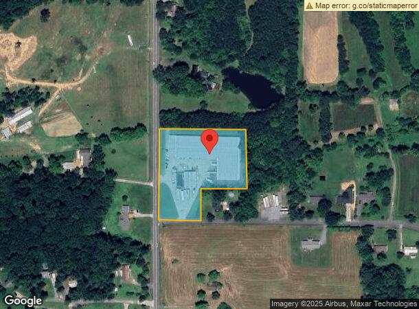
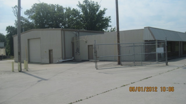
Property Record
402 Lower Dawnville Rd Ne, Dalton, GA 30721
NEARBY LISTINGS FOR SALE OR LEASE
-
-
View all Dalton listings for sale on LoopNet.com
Property Detail
402 Lower Dawnville Rd Ne
Dalton, GA
Comm Land (Rural)
09-144-07-000
3.01A HARMONY CHURCH RD
Storebuilding
Whitfield
X
Georgia
13213C0100D
144
2023
3.01 AC
2023
Georgia Northwest
000200
Other Market Areas
46,110 SF
DEMOGRAPHICS near 402 Lower Dawnville Rd Ne
1 Mile
3 Mile
5 Mile
2024 Total Population
824
9,800
46,537
2029 Population
822
9,887
46,872
Pop Growth 2024-2029
(0.24%)
+ 0.89%
+ 0.72%
Average Age
41
38
36
2024 Total Households
302
3,338
15,638
HH Growth 2024-2029
(0.33%)
+ 0.87%
+ 0.75%
Median Household Inc
$45,909
$44,599
$46,531
Avg Household Size
2.70
2.90
2.90
2024 Avg HH Vehicles
3.00
2.00
2.00
Median Home Value
$207,831
$173,175
$156,872
Median Year Built
1989
1986
1986
Nearby Places
- Restaurants
- Banks
- Shops
- Fitness
- Groceries
PUBLIC TRANSPORTATION
AIRPORT
Lovell Field
DRIVE
WALK
Distance
Lovell Field
46 min
33.5 mi
Freight Ports
Georgia Ports - Savannah
DRIVE
WALK
Distance
Georgia Ports - Savannah
385 min
341.6 mi
Nearby Properties
Address
Land Use
TOTAL SIZE
Lot Size
Zoning
Address
Land Use
TOTAL SIZE
Lot Size
Zoning
346,476 SF
31.41 AC
Address
Land Use
TOTAL SIZE
Lot Size
Zoning
230,903 SF
37.16 AC
Address
Land Use
TOTAL SIZE
Lot Size
Zoning
195,990 SF
60.25 AC
Address
Land Use
TOTAL SIZE
Lot Size
Zoning
784,920 SF
56.60 AC
Address
Land Use
TOTAL SIZE
Lot Size
Zoning
127,376 SF
5.64 AC
Address
Land Use
TOTAL SIZE
Lot Size
Zoning
29,434 SF
6.36 AC
Address
Land Use
TOTAL SIZE
Lot Size
Zoning
71,091 SF
44.70 AC
Address
Land Use
TOTAL SIZE
Lot Size
Zoning
211,512 SF
3.60 AC
Address
Land Use
TOTAL SIZE
Lot Size
Zoning
2,292.21 AC
Address
Land Use
TOTAL SIZE
Lot Size
Zoning
43,239 SF
6.80 AC
Address
Land Use
TOTAL SIZE
Lot Size
Zoning
20,561 SF
3.35 AC
Address
Land Use
TOTAL SIZE
Lot Size
Zoning
55,187 SF
38.56 AC
Address
Land Use
TOTAL SIZE
Lot Size
Zoning
139,213 SF
2.42 AC
Address
Land Use
TOTAL SIZE
Lot Size
Zoning
103,060 SF
11.32 AC
Address
Land Use
TOTAL SIZE
Lot Size
Zoning
440,012 SF
34.62 AC
IND
Address
Land Use
TOTAL SIZE
Lot Size
Zoning
28,782 SF
6.24 AC
Address
Land Use
TOTAL SIZE
Lot Size
Zoning
8,900 SF
1.21 AC
Address
Land Use
TOTAL SIZE
Lot Size
Zoning
25,099 SF
4.78 AC
Address
Land Use
TOTAL SIZE
Lot Size
Zoning
34,875 SF
4.06 AC
Address
Land Use
TOTAL SIZE
Lot Size
Zoning
139,213 SF
0.06 AC
Address
Land Use
TOTAL SIZE
Lot Size
Zoning
13,345 SF
5.08 AC
Address
Land Use
TOTAL SIZE
Lot Size
Zoning
100,425 SF
3.36 AC
Address
Land Use
TOTAL SIZE
Lot Size
Zoning
61,114 SF
2.01 AC
Address
Land Use
TOTAL SIZE
Lot Size
Zoning
48.56 AC
Address
Land Use
TOTAL SIZE
Lot Size
Zoning
Address
Land Use
TOTAL SIZE
Lot Size
Zoning
5,320 SF
2.80 AC
Address
Land Use
TOTAL SIZE
Lot Size
Zoning
3,880 SF
4.45 AC
Address
Land Use
TOTAL SIZE
Lot Size
Zoning
3,717 SF
2 AC
Address
Land Use
TOTAL SIZE
Lot Size
Zoning
110,000 SF
2.74 AC
Address
Land Use
TOTAL SIZE
Lot Size
Zoning
54,025 SF
0.90 AC
The World's #1 Commercial Real Estate Marketplace
Connect with us
© 2025 CoStar Group
The information above has been obtained from sources believed reliable. While we do not doubt its accuracy we have not verified it and make no guarantee, warranty or representation about it. It is your responsibility to independently confirm its accuracy and completeness. Any projections, opinions, assumptions, or estimates used are for example only and do not represent the current or future performance of the property. The value of this transaction to you depends on tax and other factors which should be evaluated by your tax, financial, and legal advisors. You and your advisors should conduct a careful, independent investigation of the property to determine to your satisfaction the suitability of the property for your needs.