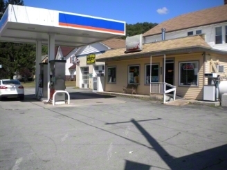
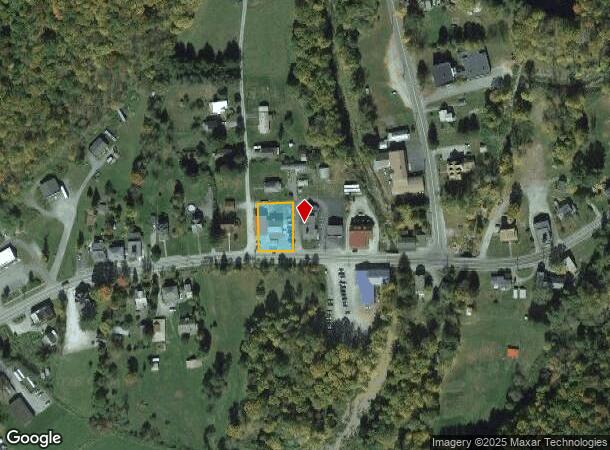
Property Record
4026 State Route 52, Youngsville, NY 12791
NEARBY LISTINGS FOR SALE OR LEASE
-
-
View all Youngsville listings for sale on LoopNet.com
Property Detail
4026 State Route 52
Servicestation
Sullivan
X
New York
36105C0270F
16.000
2024
0.45 AC
2023
Hudson Valley Area
950400
Other Market Areas
1,800 SF
2289-019-0-0002-016-000
DEMOGRAPHICS near 4026 State Route 52
1 Mile
3 Mile
5 Mile
2024 Total Population
207
1,584
3,951
2029 Population
199
1,534
3,892
Pop Growth 2024-2029
(3.86%)
(3.16%)
(1.49%)
Average Age
47
47
46
2024 Total Households
88
667
1,675
HH Growth 2024-2029
(3.41%)
(3.00%)
(1.25%)
Median Household Inc
$64,500
$66,585
$63,369
Avg Household Size
2.30
2.20
2.30
2024 Avg HH Vehicles
2.00
2.00
2.00
Median Home Value
$219,231
$233,333
$226,284
Median Year Built
1966
1968
1968
Nearby Places
- Restaurants
- Banks
- Shops
- Fitness
- Groceries
Nearby Properties
Address
Land Use
TOTAL SIZE
Lot Size
Zoning
Address
Land Use
TOTAL SIZE
Lot Size
Zoning
Address
Land Use
TOTAL SIZE
Lot Size
Zoning
Address
Land Use
TOTAL SIZE
Lot Size
Zoning
7,028 SF
0.81 AC
CM
Address
Land Use
TOTAL SIZE
Lot Size
Zoning
13,424 SF
8.37 AC
RU
Address
Land Use
TOTAL SIZE
Lot Size
Zoning
840 SF
1 AC
SD
Address
Land Use
TOTAL SIZE
Lot Size
Zoning
21,758 SF
8.40 AC
RD
Address
Land Use
TOTAL SIZE
Lot Size
Zoning
9,100 SF
2.70 AC
SC
Address
Land Use
TOTAL SIZE
Lot Size
Zoning
6,976 SF
0.13 AC
CM
Address
Land Use
TOTAL SIZE
Lot Size
Zoning
Address
Land Use
TOTAL SIZE
Lot Size
Zoning
12,352 SF
0.75 AC
BD
Address
Land Use
TOTAL SIZE
Lot Size
Zoning
2,787 SF
105.89 AC
AC
Address
Land Use
TOTAL SIZE
Lot Size
Zoning
13,829 SF
7.61 AC
DD
Address
Land Use
TOTAL SIZE
Lot Size
Zoning
2,142 SF
41.91 AC
AC
Address
Land Use
TOTAL SIZE
Lot Size
Zoning
2,040 SF
2.08 AC
RU
Address
Land Use
TOTAL SIZE
Lot Size
Zoning
1,552 SF
100 AC
AC
Address
Land Use
TOTAL SIZE
Lot Size
Zoning
5,120 SF
1.56 AC
BD
Address
Land Use
TOTAL SIZE
Lot Size
Zoning
3,436 SF
14.22 AC
SD
Address
Land Use
TOTAL SIZE
Lot Size
Zoning
4,452 SF
84.76 AC
CD
Address
Land Use
TOTAL SIZE
Lot Size
Zoning
6,000 SF
3.58 AC
RB
Address
Land Use
TOTAL SIZE
Lot Size
Zoning
4,224 SF
0.70 AC
DD
Address
Land Use
TOTAL SIZE
Lot Size
Zoning
1,440 SF
55 AC
AC
Address
Land Use
TOTAL SIZE
Lot Size
Zoning
3,564 SF
18.10 AC
AC
Address
Land Use
TOTAL SIZE
Lot Size
Zoning
10,704 SF
11.70 AC
SD
Address
Land Use
TOTAL SIZE
Lot Size
Zoning
5,266 SF
1.50 AC
SC
Address
Land Use
TOTAL SIZE
Lot Size
Zoning
8,472 SF
10.76 AC
SD
Address
Land Use
TOTAL SIZE
Lot Size
Zoning
9,412 SF
1.12 AC
BD
Address
Land Use
TOTAL SIZE
Lot Size
Zoning
2,904 SF
75 AC
AC
Address
Land Use
TOTAL SIZE
Lot Size
Zoning
1,440 SF
559.40 AC
AC
Address
Land Use
TOTAL SIZE
Lot Size
Zoning
5,040 SF
0.22 AC
CMRS
The World's #1 Commercial Real Estate Marketplace
Connect with us
© 2025 CoStar Group
The information above has been obtained from sources believed reliable. While we do not doubt its accuracy we have not verified it and make no guarantee, warranty or representation about it. It is your responsibility to independently confirm its accuracy and completeness. Any projections, opinions, assumptions, or estimates used are for example only and do not represent the current or future performance of the property. The value of this transaction to you depends on tax and other factors which should be evaluated by your tax, financial, and legal advisors. You and your advisors should conduct a careful, independent investigation of the property to determine to your satisfaction the suitability of the property for your needs.