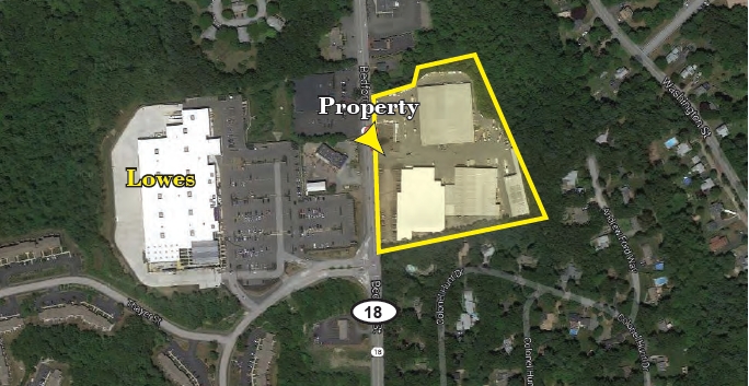
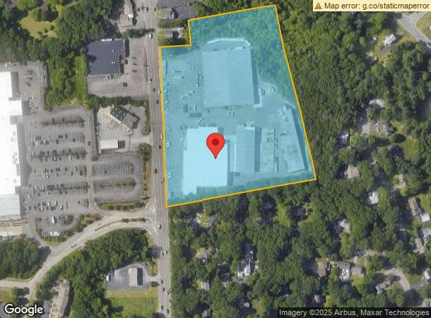
Property Record
403 Bedford St, Abington, MA 02351
NEARBY LISTINGS FOR SALE OR LEASE
Property Detail
403 Bedford St
ABIN-000039-000000-000013
Plymouth
Commercialnec
Massachusetts
X
13
25023C0177J
8.59 AC
2025
Route 24
2025
Boston
520100
Boston-Cambridge-Newton, MA-NH
DEMOGRAPHICS near 403 Bedford St
1 Mile
3 Mile
5 Mile
2024 Total Population
6,949
58,091
166,773
2029 Population
6,899
58,098
165,824
Pop Growth 2024-2029
(0.72%)
+ 0.01%
(0.57%)
Average Age
41
41
40
2024 Total Households
2,759
22,029
60,295
HH Growth 2024-2029
(0.80%)
(0.10%)
(0.60%)
Median Household Inc
$112,785
$103,619
$91,523
Avg Household Size
2.50
2.60
2.70
2024 Avg HH Vehicles
2.00
2.00
2.00
Median Home Value
$477,567
$415,102
$425,947
Median Year Built
1965
1963
1961
Nearby Places
- Restaurants
- Banks
- Shops
- Fitness
- Groceries
PUBLIC TRANSPORTATION
COMMUTER RAIL
Abington (Kingston/Plymouth Line - Massachusetts Bay Transportation Authority Commuter Rail (Purple Line))
DRIVE
WALK
Distance
Abington (Kingston/Plymouth Line - Massachusetts Bay Transportation Authority Commuter Rail (Purple Line))
3 min
1.3 mi
Whitman (Kingston/Plymouth Line - Massachusetts Bay Transportation Authority Commuter Rail (Purple Line))
DRIVE
WALK
Distance
Whitman (Kingston/Plymouth Line - Massachusetts Bay Transportation Authority Commuter Rail (Purple Line))
6 min
3.5 mi
AIRPORT
General Edward Lawrence Logan International
DRIVE
WALK
Distance
General Edward Lawrence Logan International
35 min
23.0 mi
Freight Ports
Port of Boston
DRIVE
WALK
Distance
Port of Boston
33 min
20.8 mi
Nearby Properties
Address
Land Use
TOTAL SIZE
Lot Size
Zoning
Address
Land Use
TOTAL SIZE
Lot Size
Zoning
Address
Land Use
TOTAL SIZE
Lot Size
Zoning
780 SF
10.81 AC
C5
Address
Land Use
TOTAL SIZE
Lot Size
Zoning
40,396 SF
5.56 AC
100
Address
Land Use
TOTAL SIZE
Lot Size
Zoning
172,169 SF
1.64 AC
100
Address
Land Use
TOTAL SIZE
Lot Size
Zoning
36.20 AC
Address
Land Use
TOTAL SIZE
Lot Size
Zoning
147,069 SF
1.90 AC
Address
Land Use
TOTAL SIZE
Lot Size
Zoning
35.10 AC
Address
Land Use
TOTAL SIZE
Lot Size
Zoning
168,801 SF
2.75 AC
100
Address
Land Use
TOTAL SIZE
Lot Size
Zoning
920 SF
13.48 AC
R1C
Address
Land Use
TOTAL SIZE
Lot Size
Zoning
3.72 AC
INDUST
Address
Land Use
TOTAL SIZE
Lot Size
Zoning
85,338 SF
1.85 AC
Address
Land Use
TOTAL SIZE
Lot Size
Zoning
16.12 AC
RESIDE
Address
Land Use
TOTAL SIZE
Lot Size
Zoning
10.83 AC
Address
Land Use
TOTAL SIZE
Lot Size
Zoning
14.52 AC
Address
Land Use
TOTAL SIZE
Lot Size
Zoning
48,997 SF
5.68 AC
R3
Address
Land Use
TOTAL SIZE
Lot Size
Zoning
1,172 SF
32.67 AC
R1C
Address
Land Use
TOTAL SIZE
Lot Size
Zoning
60,832 SF
2.28 AC
Address
Land Use
TOTAL SIZE
Lot Size
Zoning
60,832 SF
1.89 AC
Address
Land Use
TOTAL SIZE
Lot Size
Zoning
89,764 SF
6.77 AC
Address
Land Use
TOTAL SIZE
Lot Size
Zoning
53,538 SF
2.95 AC
C5
Address
Land Use
TOTAL SIZE
Lot Size
Zoning
9.30 AC
BUSINE
Address
Land Use
TOTAL SIZE
Lot Size
Zoning
3.63 AC
RESIDE
Address
Land Use
TOTAL SIZE
Lot Size
Zoning
2.24 AC
GB
Address
Land Use
TOTAL SIZE
Lot Size
Zoning
55.90 AC
Address
Land Use
TOTAL SIZE
Lot Size
Zoning
106,907 SF
26.42 AC
A1
Address
Land Use
TOTAL SIZE
Lot Size
Zoning
63,760 SF
9.67 AC
Address
Land Use
TOTAL SIZE
Lot Size
Zoning
49,268 SF
9.18 AC
INDUST
Address
Land Use
TOTAL SIZE
Lot Size
Zoning
127,644 SF
15.76 AC
Address
Land Use
TOTAL SIZE
Lot Size
Zoning
14.20 AC
Address
Land Use
TOTAL SIZE
Lot Size
Zoning
116,122 SF
19.57 AC
The World's #1 Commercial Real Estate Marketplace
Connect with us
© 2025 CoStar Group
The information above has been obtained from sources believed reliable. While we do not doubt its accuracy we have not verified it and make no guarantee, warranty or representation about it. It is your responsibility to independently confirm its accuracy and completeness. Any projections, opinions, assumptions, or estimates used are for example only and do not represent the current or future performance of the property. The value of this transaction to you depends on tax and other factors which should be evaluated by your tax, financial, and legal advisors. You and your advisors should conduct a careful, independent investigation of the property to determine to your satisfaction the suitability of the property for your needs.