Property Record
4032 E Southcross Blvd, San Antonio, TX 78222

Property Detail
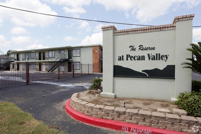
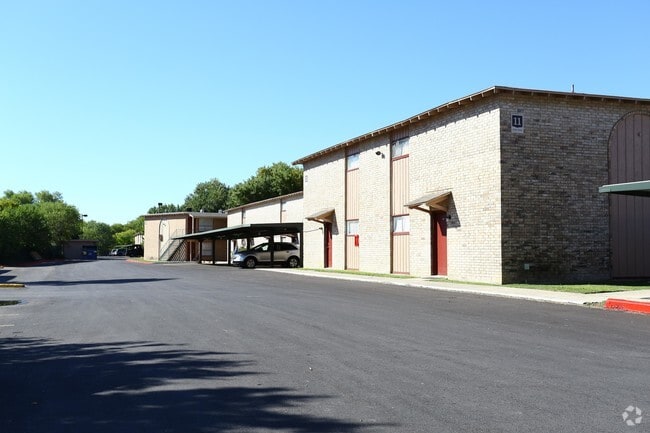
4032 E Southcross Blvd
San Antonio-New Braunfels, TX
NCB 10838 BLK LOT 6 (6.2334 AC), 9 (6.336 AC), 11, 12, PT OF H (OR P-102H), P-105 (.1153 AC) 2013-MERGED PIDS 466487,466493,466499,466500,466533 PER APPRAISER REQUEST CR # 29290. JF/GIS/2-28-13
10838-000-0091
BEXAR
Multifamilydwelling
Texas
B and X Area of moderate flood hazard, usually the area between the limits of the 100-year and 500-year floods.
91
2025
17.75 AC
2025
Pecan Valley
141300
San Antonio
332,148 SF
NEARBY LISTINGS FOR SALE OR LEASE
-
-
View all San Antonio listings for sale on LoopNet.com
DEMOGRAPHICS near 4032 E Southcross Blvd
1 mile
3 mile
5 mile
2025 Total Population
9,382
85,250
181,284
2030 Population
9,963
89,892
192,440
Pop Growth 2025-2030
+ 6.19%
+ 5.45%
+ 6.15%
Average Age
39
37
37
2025 Total Households
3,338
30,138
63,639
HH Growth 2025-2030
+ 6.35%
+ 5.51%
+ 6.24%
Median Household Inc
$50,600
$52,126
$50,442
Avg Household Size
2.70
2.70
2.80
2025 Avg HH Vehicles
2.00
2.00
2.00
Median Home Value
$215,523
$174,434
$181,026
Median Year Built
1977
1974
1969
Nearby Places
Map Layers
Map Styles
 Street
 Aerial
Layers
 Traffic
 Biking
Places
Listings with unknown addresses are not visible on the map
- Restaurants
- Banks
- Shops
- Fitness
- Groceries
PUBLIC TRANSPORTATION
COMMUTER RAIL
San Antonio Amtrak Station (Sunset Limited - Amtrak, Texas Eagle - Amtrak)
Drive
Walk
Distance
San Antonio Amtrak Station (Sunset Limited - Amtrak, Texas Eagle - Amtrak)
12 min
6.7 mi
AIRPORT
San Antonio International
Drive
Walk
Distance
San Antonio International
21 min
14.6 mi
Freight Ports
Calhoun Port
Drive
Walk
Distance
Calhoun Port
173 min
142.4 mi
Nearby Properties
Address
Land Use
TOTAL SIZE
Lot Size
Zoning
Address
Land Use
TOTAL SIZE
Lot Size
Zoning
639,848 SF
85.65 AC
Address
Land Use
TOTAL SIZE
Lot Size
Zoning
220,079 SF
28.12 AC
Address
Land Use
TOTAL SIZE
Lot Size
Zoning
348,974 SF
20.98 AC
Address
Land Use
TOTAL SIZE
Lot Size
Zoning
347,200 SF
34.77 AC
Address
Land Use
TOTAL SIZE
Lot Size
Zoning
250,400 SF
20.55 AC
Address
Land Use
TOTAL SIZE
Lot Size
Zoning
61,085 SF
16.73 AC
Address
Land Use
TOTAL SIZE
Lot Size
Zoning
380,949 SF
135.47 AC
Address
Land Use
TOTAL SIZE
Lot Size
Zoning
380,949 SF
146.39 AC
Address
Land Use
TOTAL SIZE
Lot Size
Zoning
158,546 SF
6.45 AC
Address
Land Use
TOTAL SIZE
Lot Size
Zoning
211,200 SF
7.49 AC
Address
Land Use
TOTAL SIZE
Lot Size
Zoning
273,370 SF
11.93 AC
Address
Land Use
TOTAL SIZE
Lot Size
Zoning
162,632 SF
11.06 AC
Address
Land Use
TOTAL SIZE
Lot Size
Zoning
245,745 SF
11.99 AC
Address
Land Use
TOTAL SIZE
Lot Size
Zoning
174,316 SF
15.38 AC
Address
Land Use
TOTAL SIZE
Lot Size
Zoning
88,420 SF
7.62 AC
Address
Land Use
TOTAL SIZE
Lot Size
Zoning
353,148 SF
14.10 AC
Address
Land Use
TOTAL SIZE
Lot Size
Zoning
148,525 SF
30.72 AC
Address
Land Use
TOTAL SIZE
Lot Size
Zoning
69.76 AC
Address
Land Use
TOTAL SIZE
Lot Size
Zoning
146,010 SF
9.01 AC
Address
Land Use
TOTAL SIZE
Lot Size
Zoning
145,389 SF
18.70 AC
Address
Land Use
TOTAL SIZE
Lot Size
Zoning
193,243 SF
9.03 AC
Address
Land Use
TOTAL SIZE
Lot Size
Zoning
4,920 SF
860.60 AC
Address
Land Use
TOTAL SIZE
Lot Size
Zoning
372,078 SF
10.95 AC
Address
Land Use
TOTAL SIZE
Lot Size
Zoning
148,672 SF
11.84 AC
Address
Land Use
TOTAL SIZE
Lot Size
Zoning
95,486 SF
12.54 AC
Address
Land Use
TOTAL SIZE
Lot Size
Zoning
79,740 SF
0.60 AC
Address
Land Use
TOTAL SIZE
Lot Size
Zoning
186,995 SF
14.18 AC
Address
Land Use
TOTAL SIZE
Lot Size
Zoning
144,692 SF
10.83 AC
Address
Land Use
TOTAL SIZE
Lot Size
Zoning
42.31 AC
The World's #1 Commercial Real Estate Marketplace
Connect with us
© 2026 CoStar Group
The information above has been obtained from sources believed reliable. While we do not doubt its accuracy we have not verified it and make no guarantee, warranty or representation about it. It is your responsibility to independently confirm its accuracy and completeness. Any projections, opinions, assumptions, or estimates used are for example only and do not represent the current or future performance of the property. The value of this transaction to you depends on tax and other factors which should be evaluated by your tax, financial, and legal advisors. You and your advisors should conduct a careful, independent investigation of the property to determine to your satisfaction the suitability of the property for your needs.