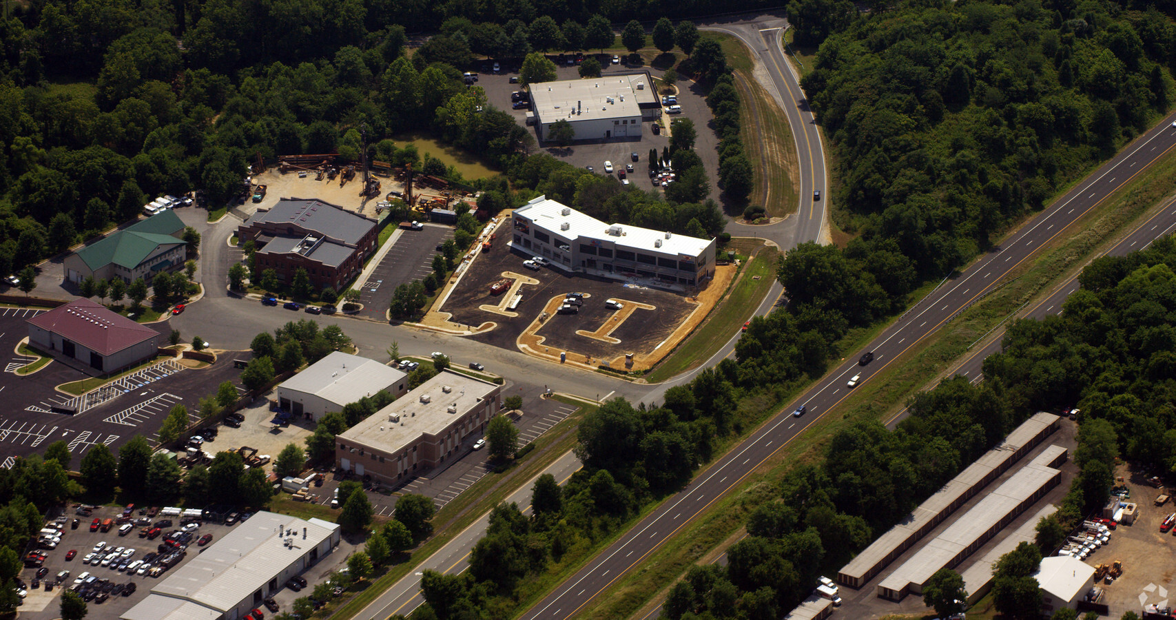
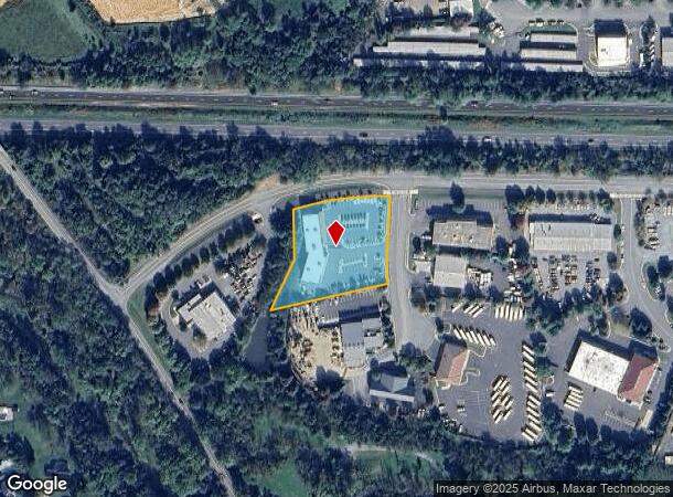
Property Record
405 Browning Ct, Purcellville, VA 20132
NEARBY LISTINGS FOR SALE OR LEASE
Property Detail
405 Browning Ct
Washington-Arlington-Alexandria, DC-VA-MD-WV
Browning Ind Pk
487-15-4579
BROWNING IND PK LOT 2 200912280085431 200601110003934 (2) 200803080018209P
Vehiclerentalsvehiclesales
Loudoun
X
Virginia
51107C0088E
2
2024
1.62 AC
2024
Leesburg/West Loudoun
610702
Washington, DC
23,207 SF
DEMOGRAPHICS near 405 Browning Ct
1 Mile
3 Mile
5 Mile
2024 Total Population
4,515
19,609
28,387
2029 Population
4,854
21,044
30,523
Pop Growth 2024-2029
+ 7.51%
+ 7.32%
+ 7.52%
Average Age
38
38
39
2024 Total Households
1,446
6,089
8,937
HH Growth 2024-2029
+ 7.68%
+ 7.44%
+ 7.64%
Median Household Inc
$154,094
$160,823
$169,347
Avg Household Size
3.10
3.20
3.10
2024 Avg HH Vehicles
3.00
3.00
3.00
Median Home Value
$693,877
$672,059
$715,712
Median Year Built
1996
1997
1996
Nearby Places
- Restaurants
- Banks
- Shops
- Fitness
- Groceries
PUBLIC TRANSPORTATION
AIRPORT
Washington Dulles International
DRIVE
WALK
Distance
Washington Dulles International
27 min
25.5 mi
Nearby Properties
Address
Land Use
TOTAL SIZE
Lot Size
Zoning
Address
Land Use
TOTAL SIZE
Lot Size
Zoning
347,910 SF
215.89 AC
PV:X
Address
Land Use
TOTAL SIZE
Lot Size
Zoning
183,505 SF
106.46 AC
PV:X
Address
Land Use
TOTAL SIZE
Lot Size
Zoning
244,039 SF
77.17 AC
AR1
Address
Land Use
TOTAL SIZE
Lot Size
Zoning
221,396 SF
30 AC
PV:IP
Address
Land Use
TOTAL SIZE
Lot Size
Zoning
79,555 SF
8.91 AC
PV:MC
Address
Land Use
TOTAL SIZE
Lot Size
Zoning
152,836 SF
20.99 AC
PV:IP
Address
Land Use
TOTAL SIZE
Lot Size
Zoning
86,833 SF
10.85 AC
PV:MC
Address
Land Use
TOTAL SIZE
Lot Size
Zoning
77,439 SF
20 AC
PDH3
Address
Land Use
TOTAL SIZE
Lot Size
Zoning
35,560 SF
11.55 AC
PV:IP
Address
Land Use
TOTAL SIZE
Lot Size
Zoning
13,545 SF
40.99 AC
PV:IP
Address
Land Use
TOTAL SIZE
Lot Size
Zoning
80,750 SF
7.37 AC
PV:MC
Address
Land Use
TOTAL SIZE
Lot Size
Zoning
64,784 SF
10.54 AC
PV:MC
Address
Land Use
TOTAL SIZE
Lot Size
Zoning
40,913 SF
21.32 AC
JLMA3
Address
Land Use
TOTAL SIZE
Lot Size
Zoning
35,558 SF
6.53 AC
PV:MC
Address
Land Use
TOTAL SIZE
Lot Size
Zoning
46,584 SF
2.62 AC
PV:C1
Address
Land Use
TOTAL SIZE
Lot Size
Zoning
23,740 SF
6.02 AC
PV:IP
Address
Land Use
TOTAL SIZE
Lot Size
Zoning
29,884 SF
7.31 AC
PV:IP
Address
Land Use
TOTAL SIZE
Lot Size
Zoning
77,135 SF
4.08 AC
PV:R15
Address
Land Use
TOTAL SIZE
Lot Size
Zoning
52,400 SF
11.69 AC
PV:IP
Address
Land Use
TOTAL SIZE
Lot Size
Zoning
12,000 SF
15.89 AC
PV:IP
Address
Land Use
TOTAL SIZE
Lot Size
Zoning
18,860 SF
2.17 AC
PV:IP
Address
Land Use
TOTAL SIZE
Lot Size
Zoning
36,132 SF
4.59 AC
PV:R15
Address
Land Use
TOTAL SIZE
Lot Size
Zoning
28,440 SF
1.68 AC
PV:CM1
Address
Land Use
TOTAL SIZE
Lot Size
Zoning
25,400 SF
2.47 AC
PV:CM1
Address
Land Use
TOTAL SIZE
Lot Size
Zoning
21,027 SF
3.06 AC
PV:IP
Address
Land Use
TOTAL SIZE
Lot Size
Zoning
22,953 SF
3.63 AC
PV:CM1
Address
Land Use
TOTAL SIZE
Lot Size
Zoning
34,020 SF
1.88 AC
PV:MC
Address
Land Use
TOTAL SIZE
Lot Size
Zoning
12,608 SF
2.36 AC
PV:CM1
Address
Land Use
TOTAL SIZE
Lot Size
Zoning
27,000 SF
1.86 AC
PV:M1
Address
Land Use
TOTAL SIZE
Lot Size
Zoning
17,000 SF
18.99 AC
PDGI
The World's #1 Commercial Real Estate Marketplace
Connect with us
© 2025 CoStar Group
The information above has been obtained from sources believed reliable. While we do not doubt its accuracy we have not verified it and make no guarantee, warranty or representation about it. It is your responsibility to independently confirm its accuracy and completeness. Any projections, opinions, assumptions, or estimates used are for example only and do not represent the current or future performance of the property. The value of this transaction to you depends on tax and other factors which should be evaluated by your tax, financial, and legal advisors. You and your advisors should conduct a careful, independent investigation of the property to determine to your satisfaction the suitability of the property for your needs.