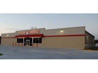
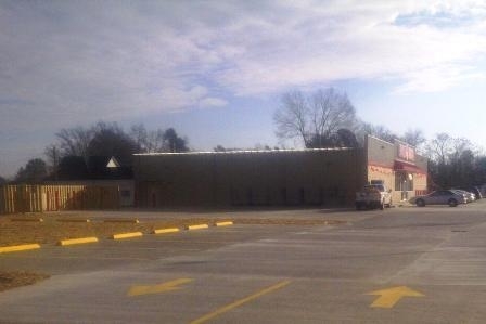
Property Record
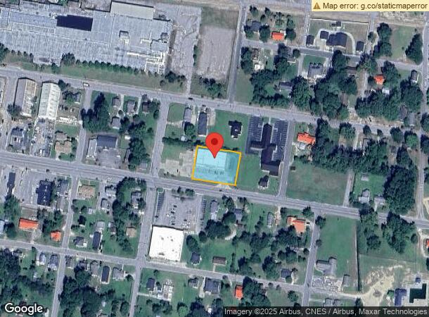
407 E Broad St, Saint Pauls, NC 28384
NEARBY LISTINGS FOR SALE OR LEASE
Property Detail
407 E Broad St
Lumberton, NC
St Pauls
3811-05-018
LTS 4 7 BL 61 MCGEACHY
Restaurantbuilding
Robeson
X
North Carolina
3720030800J
4,7
2024
0.68 AC
2024
North Carolina Southeast Area
960102
Other Market Areas
9,240 SF
DEMOGRAPHICS near 407 E Broad St
1 Mile
3 Mile
5 Mile
2024 Total Population
2,821
5,917
9,913
2029 Population
2,843
5,932
9,916
Pop Growth 2024-2029
+ 0.78%
+ 0.25%
+ 0.03%
Average Age
39
39
39
2024 Total Households
1,108
2,265
3,706
HH Growth 2024-2029
+ 0.63%
+ 0.26%
+ 0.03%
Median Household Inc
$39,422
$39,908
$41,575
Avg Household Size
2.60
2.60
2.60
2024 Avg HH Vehicles
2.00
2.00
2.00
Median Home Value
$94,812
$83,828
$83,399
Median Year Built
1974
1981
1986
Nearby Places
- Restaurants
- Banks
- Shops
- Fitness
- Groceries
PUBLIC TRANSPORTATION
AIRPORT
Fayetteville Regional/Grannis Field
DRIVE
WALK
Distance
Fayetteville Regional/Grannis Field
22 min
16.4 mi
Freight Ports
Port of Wilmington
DRIVE
WALK
Distance
Port of Wilmington
115 min
79.8 mi
SALE & LEASE HISTORY
LISTING DATE
SALE/LEASE

Jun 22, 2018
For Sale
Nearby Properties
Address
Land Use
TOTAL SIZE
Lot Size
Zoning
Address
Land Use
TOTAL SIZE
Lot Size
Zoning
269,166 SF
48.33 AC
Address
Land Use
TOTAL SIZE
Lot Size
Zoning
81,449 SF
23.50 AC
RECREATION
Address
Land Use
TOTAL SIZE
Lot Size
Zoning
235,807 SF
39.90 AC
INDUSTRIAL
Address
Land Use
TOTAL SIZE
Lot Size
Zoning
48,818 SF
21.70 AC
RECREATION
Address
Land Use
TOTAL SIZE
Lot Size
Zoning
26,844 SF
8 AC
RA20
Address
Land Use
TOTAL SIZE
Lot Size
Zoning
60,552 SF
10.19 AC
RECREATION
Address
Land Use
TOTAL SIZE
Lot Size
Zoning
41,260 SF
4.95 AC
HOSPITALIT
Address
Land Use
TOTAL SIZE
Lot Size
Zoning
15 AC
RECREATION
Address
Land Use
TOTAL SIZE
Lot Size
Zoning
38,165 SF
5.93 AC
HB
Address
Land Use
TOTAL SIZE
Lot Size
Zoning
20,896 SF
28.85 AC
Address
Land Use
TOTAL SIZE
Lot Size
Zoning
28,321 SF
2.93 AC
RA20
Address
Land Use
TOTAL SIZE
Lot Size
Zoning
11,400 SF
3.27 AC
RA20
Address
Land Use
TOTAL SIZE
Lot Size
Zoning
23,730 SF
1.12 AC
HOSPITALIT
Address
Land Use
TOTAL SIZE
Lot Size
Zoning
10,230 SF
1.03 AC
HB
Address
Land Use
TOTAL SIZE
Lot Size
Zoning
400 SF
313.24 AC
RA
Address
Land Use
TOTAL SIZE
Lot Size
Zoning
4,401 SF
2.16 AC
HOSPITALIT
Address
Land Use
TOTAL SIZE
Lot Size
Zoning
29,150 SF
6.04 AC
HOSPITALIT
Address
Land Use
TOTAL SIZE
Lot Size
Zoning
12,300 SF
2.01 AC
RA20
Address
Land Use
TOTAL SIZE
Lot Size
Zoning
5,132 SF
3.38 AC
LR8
Address
Land Use
TOTAL SIZE
Lot Size
Zoning
2,670 SF
4 AC
LR8
Address
Land Use
TOTAL SIZE
Lot Size
Zoning
17,307 SF
0.68 AC
R10
Address
Land Use
TOTAL SIZE
Lot Size
Zoning
4,675 SF
3.56 AC
HOSPITALIT
Address
Land Use
TOTAL SIZE
Lot Size
Zoning
7,662 SF
1.54 AC
R8
Address
Land Use
TOTAL SIZE
Lot Size
Zoning
2,808 SF
1.79 AC
HOSPITALIT
Address
Land Use
TOTAL SIZE
Lot Size
Zoning
10,960 SF
2 AC
RA20
Address
Land Use
TOTAL SIZE
Lot Size
Zoning
6,724 SF
1.03 AC
R10
Address
Land Use
TOTAL SIZE
Lot Size
Zoning
3,806 SF
2.01 AC
HB
Address
Land Use
TOTAL SIZE
Lot Size
Zoning
33.71 AC
RA
Address
Land Use
TOTAL SIZE
Lot Size
Zoning
11,582 SF
7.12 AC
R12
Address
Land Use
TOTAL SIZE
Lot Size
Zoning
12,820 SF
1.73 AC
RA20
The World's #1 Commercial Real Estate Marketplace
Connect with us
© 2025 CoStar Group
The information above has been obtained from sources believed reliable. While we do not doubt its accuracy we have not verified it and make no guarantee, warranty or representation about it. It is your responsibility to independently confirm its accuracy and completeness. Any projections, opinions, assumptions, or estimates used are for example only and do not represent the current or future performance of the property. The value of this transaction to you depends on tax and other factors which should be evaluated by your tax, financial, and legal advisors. You and your advisors should conduct a careful, independent investigation of the property to determine to your satisfaction the suitability of the property for your needs.