Property Record
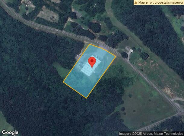
4083 Robinson Rd, Newton, NC 28658
NEARBY LISTINGS FOR SALE OR LEASE
Property Detail
4083 Robinson Rd
3629091631470000
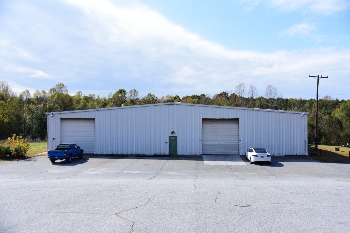
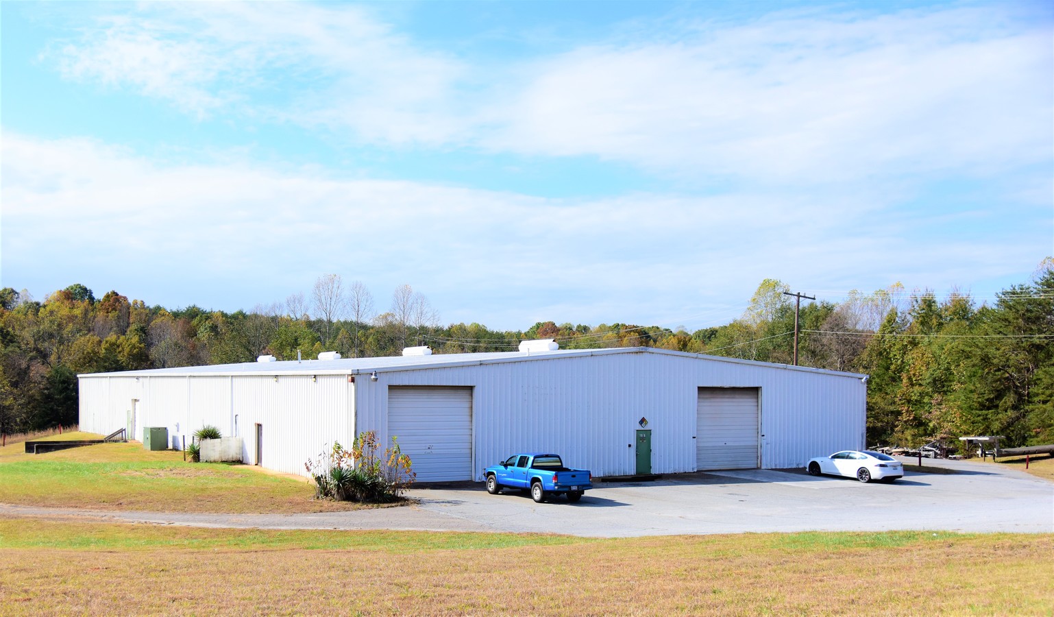
Ray Hunsucker Property
Warehouse
4083 ROBINSON RD
X
Catawba
3710362900J
North Carolina
2024
3.58 AC
2024
Catawba County
011702
Charlotte
21,000 SF
Hickory-Lenoir-Morganton, NC
DEMOGRAPHICS near 4083 Robinson Rd
1 Mile
3 Mile
5 Mile
2024 Total Population
1,183
8,810
28,847
2029 Population
1,227
9,170
30,139
Pop Growth 2024-2029
+ 3.72%
+ 4.09%
+ 4.48%
Average Age
43
43
41
2024 Total Households
438
3,434
11,399
HH Growth 2024-2029
+ 3.65%
+ 4.05%
+ 4.42%
Median Household Inc
$84,239
$73,761
$64,335
Avg Household Size
2.70
2.50
2.40
2024 Avg HH Vehicles
3.00
2.00
2.00
Median Home Value
$250,308
$218,944
$181,905
Median Year Built
1990
1986
1984
Nearby Places
- Restaurants
- Banks
- Shops
- Fitness
- Groceries
SALE & LEASE HISTORY
LISTING DATE
SALE/LEASE

Nov 27, 2019
For Sale
Nearby Properties
Address
Land Use
TOTAL SIZE
Lot Size
Zoning
Address
Land Use
TOTAL SIZE
Lot Size
Zoning
1,523,297 SF
245.71 AC
321-ED(I)
Address
Land Use
TOTAL SIZE
Lot Size
Zoning
219,033 SF
32.95 AC
IND-CZ
Address
Land Use
TOTAL SIZE
Lot Size
Zoning
385,204 SF
41.56 AC
321-ED(I)
Address
Land Use
TOTAL SIZE
Lot Size
Zoning
300,990 SF
30.42 AC
IND-CZ
Address
Land Use
TOTAL SIZE
Lot Size
Zoning
191,040 SF
25.30 AC
IND-CZ
Address
Land Use
TOTAL SIZE
Lot Size
Zoning
121,170 SF
22.34 AC
IND-CZ
Address
Land Use
TOTAL SIZE
Lot Size
Zoning
17.15 AC
R-20
Address
Land Use
TOTAL SIZE
Lot Size
Zoning
15.43 AC
R-20
Address
Land Use
TOTAL SIZE
Lot Size
Zoning
47.79 AC
R-20A
Address
Land Use
TOTAL SIZE
Lot Size
Zoning
33,212 SF
190.25 AC
R-20
Address
Land Use
TOTAL SIZE
Lot Size
Zoning
11,281 SF
10.37 AC
321-ED(I)
Address
Land Use
TOTAL SIZE
Lot Size
Zoning
43,831 SF
7.48 AC
PD-SC-C
Address
Land Use
TOTAL SIZE
Lot Size
Zoning
10,969 SF
34.28 AC
R-20
Address
Land Use
TOTAL SIZE
Lot Size
Zoning
70,328 SF
57.78 AC
321-ED(I)
Address
Land Use
TOTAL SIZE
Lot Size
Zoning
17.54 AC
R-20
Address
Land Use
TOTAL SIZE
Lot Size
Zoning
7,369 SF
2.07 AC
PD-SC-C
Address
Land Use
TOTAL SIZE
Lot Size
Zoning
10.66 AC
R-20
Address
Land Use
TOTAL SIZE
Lot Size
Zoning
58,107 SF
17.72 AC
321-ED(I)
Address
Land Use
TOTAL SIZE
Lot Size
Zoning
10,300 SF
222.22 AC
321-ED(I)
Address
Land Use
TOTAL SIZE
Lot Size
Zoning
44,100 SF
12.46 AC
IND
Address
Land Use
TOTAL SIZE
Lot Size
Zoning
13,254 SF
9.18 AC
R-20
Address
Land Use
TOTAL SIZE
Lot Size
Zoning
32,440 SF
12.61 AC
321-ED(I)
Address
Land Use
TOTAL SIZE
Lot Size
Zoning
5,285 SF
3.33 AC
B-2
Address
Land Use
TOTAL SIZE
Lot Size
Zoning
180.32 AC
R-20
Address
Land Use
TOTAL SIZE
Lot Size
Zoning
110.80 AC
321-ED(I)
Address
Land Use
TOTAL SIZE
Lot Size
Zoning
8,925 SF
5.40 AC
R-20
Address
Land Use
TOTAL SIZE
Lot Size
Zoning
16,288 SF
2.70 AC
R-20
Address
Land Use
TOTAL SIZE
Lot Size
Zoning
89.63 AC
IND
Address
Land Use
TOTAL SIZE
Lot Size
Zoning
9,173 SF
0.93 AC
B-2
Address
Land Use
TOTAL SIZE
Lot Size
Zoning
7,224 SF
8.86 AC
R-20
The World's #1 Commercial Real Estate Marketplace
Connect with us
© 2025 CoStar Group
The information above has been obtained from sources believed reliable. While we do not doubt its accuracy we have not verified it and make no guarantee, warranty or representation about it. It is your responsibility to independently confirm its accuracy and completeness. Any projections, opinions, assumptions, or estimates used are for example only and do not represent the current or future performance of the property. The value of this transaction to you depends on tax and other factors which should be evaluated by your tax, financial, and legal advisors. You and your advisors should conduct a careful, independent investigation of the property to determine to your satisfaction the suitability of the property for your needs.