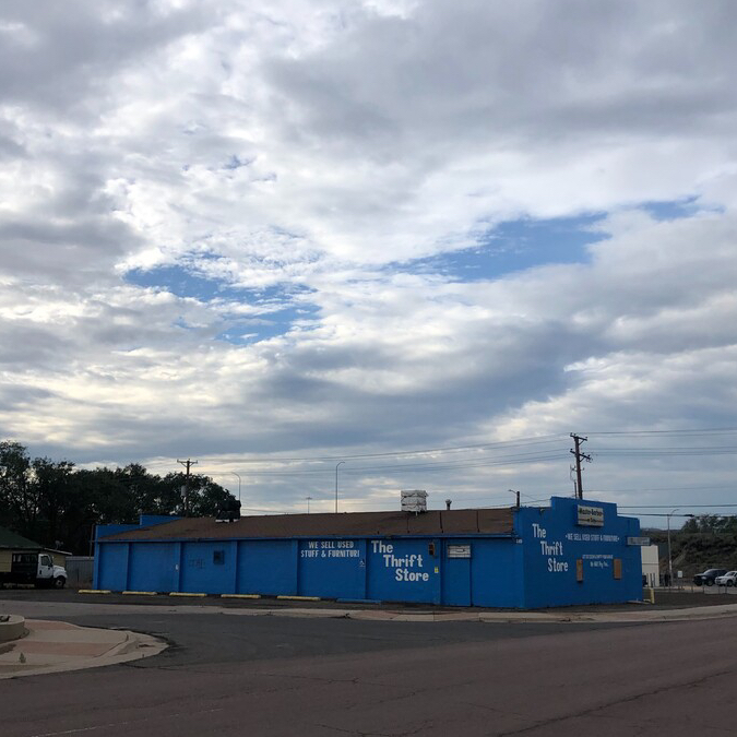
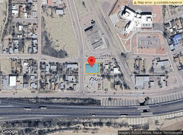
Property Record
409 N Ninth St, Gallup, NM 87301
NEARBY LISTINGS FOR SALE OR LEASE
Property Detail
409 N Ninth St
Gallup, NM
Mapel Addn
R012289
THE SOUTH PORTION OF LOTS 11 THRU 16, BLOCK 2, MAPEL ADDN.DOC 341822 09/15/08 DOC 363401 05/31/13 DOC 377024 07/29/16 DOC 377253 08/15/16 CODE 2-106-088-343-256
Commercialnec
Mckinley
AO
New Mexico
35031C1520E
11-16
2024
0.40 AC
2024
Gallup/Grants
945400
Other Market Areas
DEMOGRAPHICS near 409 N Ninth St
1 Mile
3 Mile
5 Mile
2024 Total Population
5,012
16,355
23,452
2029 Population
4,820
15,768
22,489
Pop Growth 2024-2029
(3.83%)
(3.59%)
(4.11%)
Average Age
36
37
37
2024 Total Households
1,773
5,843
8,064
HH Growth 2024-2029
(3.55%)
(3.34%)
(3.87%)
Median Household Inc
$45,442
$52,577
$53,399
Avg Household Size
2.60
2.70
2.80
2024 Avg HH Vehicles
2.00
2.00
2.00
Median Home Value
$125,584
$141,648
$126,365
Median Year Built
1969
1972
1976
Nearby Places
- Restaurants
- Banks
- Shops
- Fitness
- Groceries
PUBLIC TRANSPORTATION
COMMUTER RAIL
Gallup Amtrak Station (Southwest Chief - Amtrak)
DRIVE
WALK
Distance
Gallup Amtrak Station (Southwest Chief - Amtrak)
2 min
19 min
1.0 mi
Freight Ports
Port of San Diego
DRIVE
WALK
Distance
Port of San Diego
719 min
671.6 mi
SALE & LEASE HISTORY
LISTING DATE
SALE/LEASE

Jun 29, 2020
For Sale
Jul 02, 2020
For Lease
Nearby Properties
Address
Land Use
TOTAL SIZE
Lot Size
Zoning
Address
Land Use
TOTAL SIZE
Lot Size
Zoning
23.14 AC
Address
Land Use
TOTAL SIZE
Lot Size
Zoning
2.15 AC
Address
Land Use
TOTAL SIZE
Lot Size
Zoning
17.68 AC
Address
Land Use
TOTAL SIZE
Lot Size
Zoning
Address
Land Use
TOTAL SIZE
Lot Size
Zoning
1.43 AC
Address
Land Use
TOTAL SIZE
Lot Size
Zoning
11.85 AC
Address
Land Use
TOTAL SIZE
Lot Size
Zoning
Address
Land Use
TOTAL SIZE
Lot Size
Zoning
7.17 AC
Address
Land Use
TOTAL SIZE
Lot Size
Zoning
2.33 AC
Address
Land Use
TOTAL SIZE
Lot Size
Zoning
Address
Land Use
TOTAL SIZE
Lot Size
Zoning
Address
Land Use
TOTAL SIZE
Lot Size
Zoning
1.26 AC
Address
Land Use
TOTAL SIZE
Lot Size
Zoning
0.97 AC
Address
Land Use
TOTAL SIZE
Lot Size
Zoning
7.38 AC
Address
Land Use
TOTAL SIZE
Lot Size
Zoning
Address
Land Use
TOTAL SIZE
Lot Size
Zoning
1.98 AC
Address
Land Use
TOTAL SIZE
Lot Size
Zoning
3.17 AC
Address
Land Use
TOTAL SIZE
Lot Size
Zoning
Address
Land Use
TOTAL SIZE
Lot Size
Zoning
1.40 AC
Address
Land Use
TOTAL SIZE
Lot Size
Zoning
1.48 AC
Address
Land Use
TOTAL SIZE
Lot Size
Zoning
7.49 AC
Address
Land Use
TOTAL SIZE
Lot Size
Zoning
0.60 AC
Address
Land Use
TOTAL SIZE
Lot Size
Zoning
3.31 AC
Address
Land Use
TOTAL SIZE
Lot Size
Zoning
5.93 AC
Address
Land Use
TOTAL SIZE
Lot Size
Zoning
1.95 AC
Address
Land Use
TOTAL SIZE
Lot Size
Zoning
Address
Land Use
TOTAL SIZE
Lot Size
Zoning
1.20 AC
Address
Land Use
TOTAL SIZE
Lot Size
Zoning
0.75 AC
Address
Land Use
TOTAL SIZE
Lot Size
Zoning
0.39 AC
The World's #1 Commercial Real Estate Marketplace
Connect with us
© 2025 CoStar Group
The information above has been obtained from sources believed reliable. While we do not doubt its accuracy we have not verified it and make no guarantee, warranty or representation about it. It is your responsibility to independently confirm its accuracy and completeness. Any projections, opinions, assumptions, or estimates used are for example only and do not represent the current or future performance of the property. The value of this transaction to you depends on tax and other factors which should be evaluated by your tax, financial, and legal advisors. You and your advisors should conduct a careful, independent investigation of the property to determine to your satisfaction the suitability of the property for your needs.