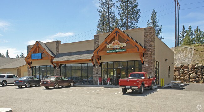
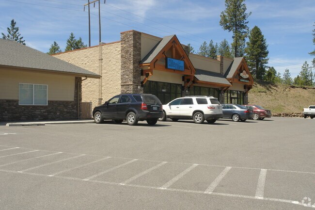
Property Record
4100 S Cheney Spokane Rd, Spokane, WA 99224

NEARBY LISTINGS FOR SALE OR LEASE
Property Detail
4100 S Cheney Spokane Rd
Spokane-Spokane Valley, WA
Latah Creek
35313.0036
LATAH CREEK NO 2 LT 2 BLK 1 (AFN# 5784049) EXC RD
Storebuilding
Spokane
X
Washington
53063C0706D
2
2025
1.15 AC
2025
South Hill
003900
Spokane
4,248 SF
DEMOGRAPHICS near 4100 S Cheney Spokane Rd
1 Mile
3 Mile
5 Mile
2024 Total Population
3,326
62,999
144,583
2029 Population
3,533
67,325
154,301
Pop Growth 2024-2029
+ 6.22%
+ 6.87%
+ 6.72%
Average Age
42
42
40
2024 Total Households
1,263
29,138
61,477
HH Growth 2024-2029
+ 6.33%
+ 7.27%
+ 7.09%
Median Household Inc
$118,597
$66,193
$62,174
Avg Household Size
2.60
2.10
2.20
2024 Avg HH Vehicles
2.00
2.00
2.00
Median Home Value
$515,571
$434,590
$384,321
Median Year Built
1986
1969
1970
Nearby Places
- Restaurants
- Banks
- Shops
- Fitness
- Groceries
PUBLIC TRANSPORTATION
COMMUTER RAIL
Spokane (Empire Builder - Amtrak)
DRIVE
WALK
Distance
Spokane (Empire Builder - Amtrak)
8 min
4.9 mi
AIRPORT
Spokane International
DRIVE
WALK
Distance
Spokane International
12 min
7.1 mi
Freight Ports
Port of Everett
DRIVE
WALK
Distance
Port of Everett
339 min
302.7 mi
Nearby Properties
Address
Land Use
TOTAL SIZE
Lot Size
Zoning
Address
Land Use
TOTAL SIZE
Lot Size
Zoning
763,627 SF
12.44 AC
OR
Address
Land Use
TOTAL SIZE
Lot Size
Zoning
270,262 SF
29.10 AC
Address
Land Use
TOTAL SIZE
Lot Size
Zoning
546,897 SF
27.69 AC
Address
Land Use
TOTAL SIZE
Lot Size
Zoning
91,882 SF
2.07 AC
OR
Address
Land Use
TOTAL SIZE
Lot Size
Zoning
124,234 SF
13.54 AC
RSF
Address
Land Use
TOTAL SIZE
Lot Size
Zoning
314,149 SF
1.07 AC
DTC
Address
Land Use
TOTAL SIZE
Lot Size
Zoning
289,705 SF
3.36 AC
OR
Address
Land Use
TOTAL SIZE
Lot Size
Zoning
50,869 SF
0.61 AC
DTC
Address
Land Use
TOTAL SIZE
Lot Size
Zoning
53,748 SF
1.26 AC
DTC
Address
Land Use
TOTAL SIZE
Lot Size
Zoning
289,573 SF
7.73 AC
RMF
Address
Land Use
TOTAL SIZE
Lot Size
Zoning
197,933 SF
37.51 AC
UR
Address
Land Use
TOTAL SIZE
Lot Size
Zoning
236,105 SF
5.01 AC
OR
Address
Land Use
TOTAL SIZE
Lot Size
Zoning
91,048 SF
3.81 AC
OR
Address
Land Use
TOTAL SIZE
Lot Size
Zoning
16,384 SF
1.21 AC
DTC
Address
Land Use
TOTAL SIZE
Lot Size
Zoning
177,707 SF
44.44 AC
LI
Address
Land Use
TOTAL SIZE
Lot Size
Zoning
159,720 SF
6.84 AC
RMF
Address
Land Use
TOTAL SIZE
Lot Size
Zoning
30,250 SF
1.05 AC
DTC
Address
Land Use
TOTAL SIZE
Lot Size
Zoning
177,044 SF
14.71 AC
LDR
Address
Land Use
TOTAL SIZE
Lot Size
Zoning
66,193 SF
1.99 AC
OR
Address
Land Use
TOTAL SIZE
Lot Size
Zoning
78,990 SF
5.58 AC
RSF
Address
Land Use
TOTAL SIZE
Lot Size
Zoning
79,200 SF
OR
Address
Land Use
TOTAL SIZE
Lot Size
Zoning
96,854 SF
2.40 AC
DTC
Address
Land Use
TOTAL SIZE
Lot Size
Zoning
81,833 SF
3.97 AC
OR
Address
Land Use
TOTAL SIZE
Lot Size
Zoning
107,490 SF
0.52 AC
DTG
Address
Land Use
TOTAL SIZE
Lot Size
Zoning
34,045 SF
1 AC
DTC
Address
Land Use
TOTAL SIZE
Lot Size
Zoning
94,412 SF
0.24 AC
DTC
Address
Land Use
TOTAL SIZE
Lot Size
Zoning
59,826 SF
6.78 AC
RSF
Address
Land Use
TOTAL SIZE
Lot Size
Zoning
14,200 SF
0.33 AC
DTC
Address
Land Use
TOTAL SIZE
Lot Size
Zoning
18,850 SF
0.64 AC
OR
Address
Land Use
TOTAL SIZE
Lot Size
Zoning
80,076 SF
0.49 AC
OR
The World's #1 Commercial Real Estate Marketplace
Connect with us
© 2025 CoStar Group
The information above has been obtained from sources believed reliable. While we do not doubt its accuracy we have not verified it and make no guarantee, warranty or representation about it. It is your responsibility to independently confirm its accuracy and completeness. Any projections, opinions, assumptions, or estimates used are for example only and do not represent the current or future performance of the property. The value of this transaction to you depends on tax and other factors which should be evaluated by your tax, financial, and legal advisors. You and your advisors should conduct a careful, independent investigation of the property to determine to your satisfaction the suitability of the property for your needs.