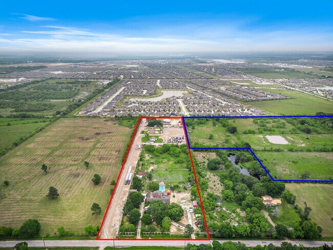
Property Record
4149 Roland Rd, Katy, TX 77493

NEARBY LISTINGS FOR SALE OR LEASE
Property Detail
4149 Roland Rd
Houston-The Woodlands-Sugar Land, TX
Abst 450 H&Tcrr Sec 61
0431160000021
TR 6 ABST 450 H&TCRR SEC 61 BLK 2
Vacantlandnec
Harris
X
Texas
48201C0585M
5 AC
2024
Katy/Grand Parkway West
2025
Houston
542902
DEMOGRAPHICS near 4149 Roland Rd
1 Mile
3 Mile
5 Mile
2024 Total Population
8,818
69,561
161,247
2029 Population
9,652
74,958
172,265
Pop Growth 2024-2029
+ 9.46%
+ 7.76%
+ 6.83%
Average Age
32
34
35
2024 Total Households
2,625
21,485
51,537
HH Growth 2024-2029
+ 9.33%
+ 7.66%
+ 6.75%
Median Household Inc
$114,472
$104,990
$91,304
Avg Household Size
3.30
3.20
3.10
2024 Avg HH Vehicles
2.00
2.00
2.00
Median Home Value
$289,482
$267,380
$252,401
Median Year Built
2011
2010
2010
Nearby Places
Map Layers
Map Styles
 Street
 Aerial
- Restaurants
- Banks
- Shops
- Fitness
- Groceries
PUBLIC TRANSPORTATION
AIRPORT
George Bush Intcntl/Houston
DRIVE
WALK
Distance
George Bush Intcntl/Houston
53 min
38.4 mi
Freight Ports
Port of Houston
DRIVE
WALK
Distance
Port of Houston
58 min
40.5 mi
SALE & LEASE HISTORY
LISTING DATE
SALE/LEASE

Oct 31, 2023
For Lease
Nov 06, 2023
For Sale
Apr 02, 2024
For Sale
Nearby Properties
Address
Land Use
TOTAL SIZE
Lot Size
Zoning
Address
Land Use
TOTAL SIZE
Lot Size
Zoning
807,360 SF
54.15 AC
Address
Land Use
TOTAL SIZE
Lot Size
Zoning
339,835 SF
12.09 AC
Address
Land Use
TOTAL SIZE
Lot Size
Zoning
324,201 SF
12.39 AC
Address
Land Use
TOTAL SIZE
Lot Size
Zoning
290,973 SF
15 AC
Address
Land Use
TOTAL SIZE
Lot Size
Zoning
347,834 SF
15.25 AC
Address
Land Use
TOTAL SIZE
Lot Size
Zoning
395,495 SF
13.83 AC
Address
Land Use
TOTAL SIZE
Lot Size
Zoning
270,728 SF
9.45 AC
Address
Land Use
TOTAL SIZE
Lot Size
Zoning
292,645 SF
12.71 AC
Address
Land Use
TOTAL SIZE
Lot Size
Zoning
439,808 SF
23.75 AC
Address
Land Use
TOTAL SIZE
Lot Size
Zoning
290,607 SF
14.50 AC
Address
Land Use
TOTAL SIZE
Lot Size
Zoning
321,565 SF
11.47 AC
Address
Land Use
TOTAL SIZE
Lot Size
Zoning
385,744 SF
25.88 AC
Address
Land Use
TOTAL SIZE
Lot Size
Zoning
195,501 SF
7.79 AC
Address
Land Use
TOTAL SIZE
Lot Size
Zoning
151,385 SF
8.58 AC
Address
Land Use
TOTAL SIZE
Lot Size
Zoning
226,076 SF
10.37 AC
Address
Land Use
TOTAL SIZE
Lot Size
Zoning
122,133 SF
13.46 AC
Address
Land Use
TOTAL SIZE
Lot Size
Zoning
123,466 SF
11.37 AC
Address
Land Use
TOTAL SIZE
Lot Size
Zoning
54,306 SF
3.78 AC
Address
Land Use
TOTAL SIZE
Lot Size
Zoning
193,230 SF
16.92 AC
Address
Land Use
TOTAL SIZE
Lot Size
Zoning
111,780 SF
12.75 AC
Address
Land Use
TOTAL SIZE
Lot Size
Zoning
62.55 AC
Address
Land Use
TOTAL SIZE
Lot Size
Zoning
78.32 AC
Address
Land Use
TOTAL SIZE
Lot Size
Zoning
119,086 SF
18.61 AC
Address
Land Use
TOTAL SIZE
Lot Size
Zoning
133,479 SF
7.46 AC
Address
Land Use
TOTAL SIZE
Lot Size
Zoning
131,811 SF
29.47 AC
Address
Land Use
TOTAL SIZE
Lot Size
Zoning
99,096 SF
27.51 AC
Address
Land Use
TOTAL SIZE
Lot Size
Zoning
161,052 SF
2.73 AC
Address
Land Use
TOTAL SIZE
Lot Size
Zoning
134,892 SF
5.62 AC
Address
Land Use
TOTAL SIZE
Lot Size
Zoning
97,985 SF
14.20 AC
Address
Land Use
TOTAL SIZE
Lot Size
Zoning
97,650 SF
7.79 AC
The World's #1 Commercial Real Estate Marketplace
Connect with us
© 2025 CoStar Group
The information above has been obtained from sources believed reliable. While we do not doubt its accuracy we have not verified it and make no guarantee, warranty or representation about it. It is your responsibility to independently confirm its accuracy and completeness. Any projections, opinions, assumptions, or estimates used are for example only and do not represent the current or future performance of the property. The value of this transaction to you depends on tax and other factors which should be evaluated by your tax, financial, and legal advisors. You and your advisors should conduct a careful, independent investigation of the property to determine to your satisfaction the suitability of the property for your needs.