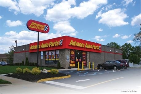
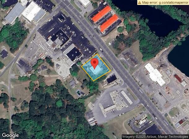
Property Record
411 E New Bern Rd, Kinston, NC 28504
NEARBY LISTINGS FOR SALE OR LEASE
Property Detail
411 E New Bern Rd
452410455574
411 E NEW BERN RD PARKLOT 20000SF ADVANCE AUTO PARTS
Storebuilding
Lenoir
AE
North Carolina
3720452400K
20000s
2024
0.98 AC
2024
Other Market Areas
011301
Kinston, NC
6,972 SF
DEMOGRAPHICS near 411 E New Bern Rd
1 Mile
3 Mile
5 Mile
2024 Total Population
367
14,872
26,221
2029 Population
365
15,049
26,165
Pop Growth 2024-2029
(0.54%)
+ 1.19%
(0.21%)
Average Age
39
41
43
2024 Total Households
158
6,607
11,295
HH Growth 2024-2029
(0.63%)
+ 1.23%
(0.19%)
Median Household Inc
$44,062
$28,404
$34,534
Avg Household Size
2.30
2.20
2.20
2024 Avg HH Vehicles
2.00
1.00
2.00
Median Home Value
$120,000
$81,746
$99,121
Median Year Built
1977
1965
1970
Nearby Places
- Restaurants
- Banks
- Shops
- Fitness
- Groceries
PUBLIC TRANSPORTATION
AIRPORT
Albert J Ellis
DRIVE
WALK
Distance
Albert J Ellis
60 min
34.3 mi
Pitt-Greenville
DRIVE
WALK
Distance
Pitt-Greenville
48 min
36.4 mi
Freight Ports
Port of Morehead City
DRIVE
WALK
Distance
Port of Morehead City
105 min
74.7 mi
Nearby Properties
Address
Land Use
TOTAL SIZE
Lot Size
Zoning
Address
Land Use
TOTAL SIZE
Lot Size
Zoning
217,381 SF
77.79 AC
O&I
Address
Land Use
TOTAL SIZE
Lot Size
Zoning
166,712 SF
23.48 AC
RA8
Address
Land Use
TOTAL SIZE
Lot Size
Zoning
85,993 SF
33.29 AC
I1
Address
Land Use
TOTAL SIZE
Lot Size
Zoning
525,504 SF
228 AC
I1
Address
Land Use
TOTAL SIZE
Lot Size
Zoning
139,392 SF
2.19 AC
RA6
Address
Land Use
TOTAL SIZE
Lot Size
Zoning
122,274 SF
1.86 AC
B2
Address
Land Use
TOTAL SIZE
Lot Size
Zoning
65,100 SF
1.91 AC
B2
Address
Land Use
TOTAL SIZE
Lot Size
Zoning
65,344 SF
27.42 AC
Address
Land Use
TOTAL SIZE
Lot Size
Zoning
69,696 SF
0.32 AC
B2
Address
Land Use
TOTAL SIZE
Lot Size
Zoning
73,536 SF
5.38 AC
B1
Address
Land Use
TOTAL SIZE
Lot Size
Zoning
106,276 SF
8.84 AC
RA5
Address
Land Use
TOTAL SIZE
Lot Size
Zoning
77,500 SF
1.30 AC
B2
Address
Land Use
TOTAL SIZE
Lot Size
Zoning
115.74 AC
RA12
Address
Land Use
TOTAL SIZE
Lot Size
Zoning
83,088 SF
1.19 AC
B2
Address
Land Use
TOTAL SIZE
Lot Size
Zoning
43,295 SF
5.69 AC
SC
Address
Land Use
TOTAL SIZE
Lot Size
Zoning
25,885 SF
88.62 AC
RA6
Address
Land Use
TOTAL SIZE
Lot Size
Zoning
39,450 SF
1.02 AC
B2
Address
Land Use
TOTAL SIZE
Lot Size
Zoning
61,056 SF
7.05 AC
O&I
Address
Land Use
TOTAL SIZE
Lot Size
Zoning
11.45 AC
RA6
Address
Land Use
TOTAL SIZE
Lot Size
Zoning
109,052 SF
7.54 AC
IB
Address
Land Use
TOTAL SIZE
Lot Size
Zoning
12.35 AC
RA5
Address
Land Use
TOTAL SIZE
Lot Size
Zoning
60,762 SF
57.80 AC
I1
Address
Land Use
TOTAL SIZE
Lot Size
Zoning
448,513 SF
104.04 AC
SC
Address
Land Use
TOTAL SIZE
Lot Size
Zoning
8,640 SF
8.03 AC
RA5
Address
Land Use
TOTAL SIZE
Lot Size
Zoning
27,938 SF
1.92 AC
RA8
Address
Land Use
TOTAL SIZE
Lot Size
Zoning
11,254 SF
16.75 AC
RA5
Address
Land Use
TOTAL SIZE
Lot Size
Zoning
12,000 SF
16.02 AC
I2
Address
Land Use
TOTAL SIZE
Lot Size
Zoning
15,918 SF
2.53 AC
RO
Address
Land Use
TOTAL SIZE
Lot Size
Zoning
9.44 AC
RA5
Address
Land Use
TOTAL SIZE
Lot Size
Zoning
6,760 SF
147.39 AC
RA6
The World's #1 Commercial Real Estate Marketplace
Connect with us
© 2025 CoStar Group
The information above has been obtained from sources believed reliable. While we do not doubt its accuracy we have not verified it and make no guarantee, warranty or representation about it. It is your responsibility to independently confirm its accuracy and completeness. Any projections, opinions, assumptions, or estimates used are for example only and do not represent the current or future performance of the property. The value of this transaction to you depends on tax and other factors which should be evaluated by your tax, financial, and legal advisors. You and your advisors should conduct a careful, independent investigation of the property to determine to your satisfaction the suitability of the property for your needs.