Property Record
4110 Independence Dr, Schnecksville, PA 18078

Current Lease Availabilities
NEARBY LISTINGS FOR SALE OR LEASE
-
-
View all Schnecksville listings for lease on LoopNet.com
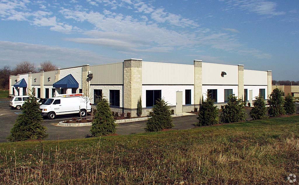
Property Detail
4110 Independence Dr
Allentown-Bethlehem-Easton, PA-NJ
North Whitehall Industrial Park
546940940300-1
LOTS: 040
Officebuilding
Lehigh
X
Pennsylvania
42077C0136F
40
2024
2.14 AC
2024
Lehigh Valley
005506
Philadelphia
15,124 SF
DEMOGRAPHICS near 4110 Independence Dr
1 Mile
3 Mile
5 Mile
2024 Total Population
2,237
13,679
41,058
2029 Population
2,243
13,749
41,380
Pop Growth 2024-2029
+ 0.27%
+ 0.51%
+ 0.78%
Average Age
41
43
43
2024 Total Households
885
5,204
15,509
HH Growth 2024-2029
+ 0.23%
+ 0.50%
+ 0.76%
Median Household Inc
$63,596
$96,190
$97,708
Avg Household Size
2.40
2.60
2.60
2024 Avg HH Vehicles
2.00
2.00
2.00
Median Home Value
$367,856
$330,527
$318,072
Median Year Built
1983
1982
1981
Nearby Places
- Restaurants
- Banks
- Shops
- Fitness
- Groceries
PUBLIC TRANSPORTATION
AIRPORT
Lehigh Valley International
DRIVE
WALK
Distance
Lehigh Valley International
22 min
10.2 mi
Freight Ports
Port of Philadelphia
DRIVE
WALK
Distance
Port of Philadelphia
80 min
62.9 mi
Nearby Properties
Address
Land Use
TOTAL SIZE
Lot Size
Zoning
Address
Land Use
TOTAL SIZE
Lot Size
Zoning
61,493 SF
47 AC
AR-I
Address
Land Use
TOTAL SIZE
Lot Size
Zoning
73,980 SF
88.46 AC
AR-I
Address
Land Use
TOTAL SIZE
Lot Size
Zoning
810,010 SF
62.47 AC
LI-B
Address
Land Use
TOTAL SIZE
Lot Size
Zoning
513,976 SF
46.77 AC
LI-B
Address
Land Use
TOTAL SIZE
Lot Size
Zoning
170,208 SF
41.45 AC
R-3
Address
Land Use
TOTAL SIZE
Lot Size
Zoning
11,966 SF
134.70 AC
AR-I
Address
Land Use
TOTAL SIZE
Lot Size
Zoning
22,007 SF
55.21 AC
AR-I
Address
Land Use
TOTAL SIZE
Lot Size
Zoning
352,946 SF
19.83 AC
LI-B
Address
Land Use
TOTAL SIZE
Lot Size
Zoning
1,662 SF
50.40 AC
VR
Address
Land Use
TOTAL SIZE
Lot Size
Zoning
66,835 SF
19.48 AC
VR
Address
Land Use
TOTAL SIZE
Lot Size
Zoning
82,305 SF
198.43 AC
SR
Address
Land Use
TOTAL SIZE
Lot Size
Zoning
40.61 AC
PC
Address
Land Use
TOTAL SIZE
Lot Size
Zoning
64,809 SF
9.66 AC
SR
Address
Land Use
TOTAL SIZE
Lot Size
Zoning
63,750 SF
9.96 AC
C
Address
Land Use
TOTAL SIZE
Lot Size
Zoning
21,947 SF
6 AC
SR
Address
Land Use
TOTAL SIZE
Lot Size
Zoning
31,168 SF
2.88 AC
AR-I
Address
Land Use
TOTAL SIZE
Lot Size
Zoning
3,611 SF
108 AC
ME-I
Address
Land Use
TOTAL SIZE
Lot Size
Zoning
28,766 SF
24.87 AC
AR-L
Address
Land Use
TOTAL SIZE
Lot Size
Zoning
30,228 SF
5.76 AC
LI-B
Address
Land Use
TOTAL SIZE
Lot Size
Zoning
6,489 SF
538.42 AC
CR
Address
Land Use
TOTAL SIZE
Lot Size
Zoning
28,346 SF
5.02 AC
AR-I
Address
Land Use
TOTAL SIZE
Lot Size
Zoning
14,724 SF
6.27 AC
VR
Address
Land Use
TOTAL SIZE
Lot Size
Zoning
14,580 SF
3.83 AC
VR
Address
Land Use
TOTAL SIZE
Lot Size
Zoning
1,200 SF
57.88 AC
AR-I
Address
Land Use
TOTAL SIZE
Lot Size
Zoning
46,469 SF
9.18 AC
PC
Address
Land Use
TOTAL SIZE
Lot Size
Zoning
42,602 SF
17.93 AC
SR
Address
Land Use
TOTAL SIZE
Lot Size
Zoning
8,864 SF
4 AC
LI-B
Address
Land Use
TOTAL SIZE
Lot Size
Zoning
28,950 SF
2.90 AC
LI-B
Address
Land Use
TOTAL SIZE
Lot Size
Zoning
12,982 SF
49.30 AC
AR-L
Address
Land Use
TOTAL SIZE
Lot Size
Zoning
1,575 SF
5.13 AC
LI-B
The World's #1 Commercial Real Estate Marketplace
Connect with us
© 2025 CoStar Group
The information above has been obtained from sources believed reliable. While we do not doubt its accuracy we have not verified it and make no guarantee, warranty or representation about it. It is your responsibility to independently confirm its accuracy and completeness. Any projections, opinions, assumptions, or estimates used are for example only and do not represent the current or future performance of the property. The value of this transaction to you depends on tax and other factors which should be evaluated by your tax, financial, and legal advisors. You and your advisors should conduct a careful, independent investigation of the property to determine to your satisfaction the suitability of the property for your needs.