Property Record
4111 Us Highway 158, Oxford, NC 27565
NEARBY LISTINGS FOR SALE OR LEASE
Property Detail
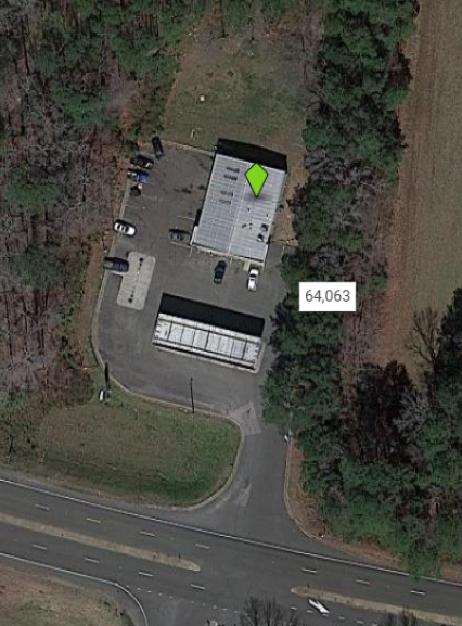
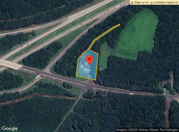
4111 Us Highway 158
193304534820
4111 HWY 158
Conveniencestore
Granville
X
North Carolina
3720193300K
1.46 AC
2023
North Carolina Northeast Area
2023
Other Market Areas
970200
Oxford, NC
3,200 SF
DEMOGRAPHICS near 4111 Us Highway 158
1 Mile
3 Mile
5 Mile
2024 Total Population
428
7,700
16,308
2029 Population
450
8,086
17,016
Pop Growth 2024-2029
+ 5.14%
+ 5.01%
+ 4.34%
Average Age
45
44
43
2024 Total Households
166
3,143
6,624
HH Growth 2024-2029
+ 5.42%
+ 4.84%
+ 4.21%
Median Household Inc
$54,615
$47,773
$48,034
Avg Household Size
2.50
2.30
2.40
2024 Avg HH Vehicles
2.00
2.00
2.00
Median Home Value
$191,666
$188,506
$186,435
Median Year Built
1982
1978
1977
Nearby Places
- Restaurants
- Banks
- Shops
- Fitness
- Groceries
Nearby Properties
Address
Land Use
TOTAL SIZE
Lot Size
Zoning
Address
Land Use
TOTAL SIZE
Lot Size
Zoning
433,560 SF
122.96 AC
I1
Address
Land Use
TOTAL SIZE
Lot Size
Zoning
8,640 SF
13.13 AC
Address
Land Use
TOTAL SIZE
Lot Size
Zoning
25,364 SF
266.74 AC
RAR6
Address
Land Use
TOTAL SIZE
Lot Size
Zoning
65,740 SF
37.29 AC
RA
Address
Land Use
TOTAL SIZE
Lot Size
Zoning
95,568 SF
22.65 AC
LI
Address
Land Use
TOTAL SIZE
Lot Size
Zoning
1,760 SF
9.91 AC
RA
Address
Land Use
TOTAL SIZE
Lot Size
Zoning
37,999 SF
10.29 AC
Address
Land Use
TOTAL SIZE
Lot Size
Zoning
83,000 SF
9.88 AC
EIA
Address
Land Use
TOTAL SIZE
Lot Size
Zoning
70,040 SF
15.32 AC
B2
Address
Land Use
TOTAL SIZE
Lot Size
Zoning
8,184 SF
280.85 AC
RA
Address
Land Use
TOTAL SIZE
Lot Size
Zoning
18.78 AC
HB
Address
Land Use
TOTAL SIZE
Lot Size
Zoning
1,504 SF
442.54 AC
I2
Address
Land Use
TOTAL SIZE
Lot Size
Zoning
5,294 SF
19.44 AC
B1
Address
Land Use
TOTAL SIZE
Lot Size
Zoning
176,080 SF
8.32 AC
Address
Land Use
TOTAL SIZE
Lot Size
Zoning
34,972 SF
19.19 AC
B1
Address
Land Use
TOTAL SIZE
Lot Size
Zoning
147,213 SF
21.90 AC
I1
Address
Land Use
TOTAL SIZE
Lot Size
Zoning
18,729 SF
6.66 AC
B1
Address
Land Use
TOTAL SIZE
Lot Size
Zoning
12,939 SF
2.88 AC
Address
Land Use
TOTAL SIZE
Lot Size
Zoning
129,168 SF
29.26 AC
I1
Address
Land Use
TOTAL SIZE
Lot Size
Zoning
14,634 SF
11.97 AC
B1
Address
Land Use
TOTAL SIZE
Lot Size
Zoning
42,806 SF
0.96 AC
B1
Address
Land Use
TOTAL SIZE
Lot Size
Zoning
14,736 SF
2 AC
B1
Address
Land Use
TOTAL SIZE
Lot Size
Zoning
29,960 SF
8.70 AC
OI
Address
Land Use
TOTAL SIZE
Lot Size
Zoning
40,100 SF
11.01 AC
B1
Address
Land Use
TOTAL SIZE
Lot Size
Zoning
15,487 SF
5.09 AC
RA
Address
Land Use
TOTAL SIZE
Lot Size
Zoning
13,952 SF
3.36 AC
B2
Address
Land Use
TOTAL SIZE
Lot Size
Zoning
36,720 SF
2.87 AC
B2
Address
Land Use
TOTAL SIZE
Lot Size
Zoning
11,600 SF
4.29 AC
OI
Address
Land Use
TOTAL SIZE
Lot Size
Zoning
8,400 SF
3.34 AC
R6
Address
Land Use
TOTAL SIZE
Lot Size
Zoning
12,926 SF
0.33 AC
The World's #1 Commercial Real Estate Marketplace
Connect with us
© 2025 CoStar Group
The information above has been obtained from sources believed reliable. While we do not doubt its accuracy we have not verified it and make no guarantee, warranty or representation about it. It is your responsibility to independently confirm its accuracy and completeness. Any projections, opinions, assumptions, or estimates used are for example only and do not represent the current or future performance of the property. The value of this transaction to you depends on tax and other factors which should be evaluated by your tax, financial, and legal advisors. You and your advisors should conduct a careful, independent investigation of the property to determine to your satisfaction the suitability of the property for your needs.