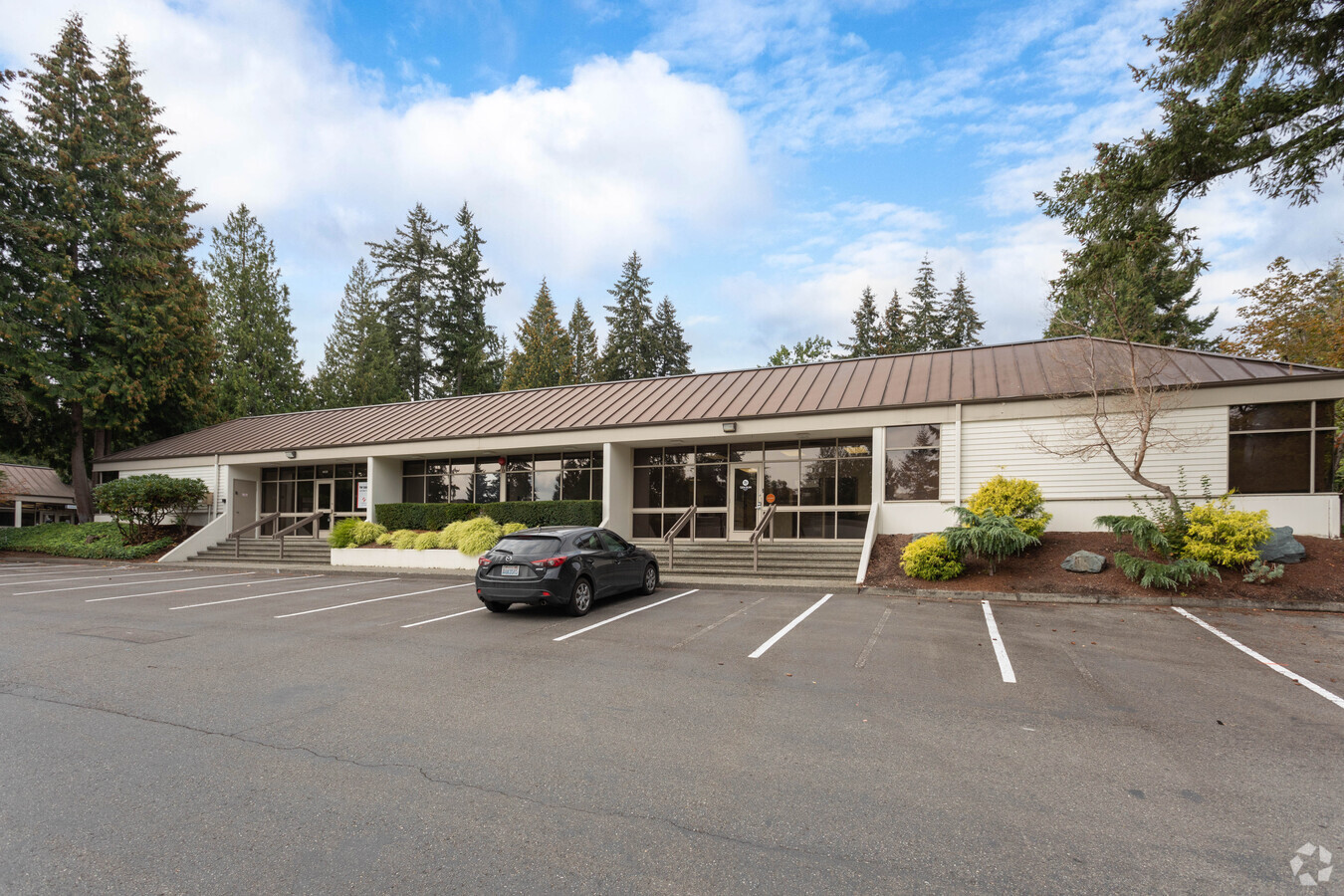
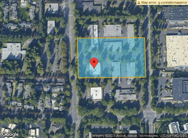
Property Record
4116 148Th Ave Ne, Redmond, WA 98052
NEARBY LISTINGS FOR SALE OR LEASE
Property Detail
4116 148Th Ave Ne
Seattle-Tacoma-Bellevue, WA
Don Koll Business Park
142505-9013
N 1/2 OF SW 1/4 OF SW 1/4 OF SW 1/4 LESS STS
Industrialpark
King
X
Washington
53033C0369G
142505
2025
4.54 AC
2024
520 Corridor
022803
Seattle/Puget Sound
153,290 SF
DEMOGRAPHICS near 4116 148Th Ave Ne
1 Mile
3 Mile
5 Mile
2024 Total Population
16,119
128,576
264,020
2029 Population
16,449
130,487
267,606
Pop Growth 2024-2029
+ 2.05%
+ 1.49%
+ 1.36%
Average Age
35
37
38
2024 Total Households
6,971
53,026
107,981
HH Growth 2024-2029
+ 2.38%
+ 1.57%
+ 1.45%
Median Household Inc
$136,084
$146,014
$154,924
Avg Household Size
2.30
2.30
2.40
2024 Avg HH Vehicles
1.00
2.00
2.00
Median Home Value
$1,066,200
$1,018,088
$1,046,563
Median Year Built
1985
1985
1987
Nearby Places
- Restaurants
- Banks
- Shops
- Fitness
- Groceries
PUBLIC TRANSPORTATION
AIRPORT
Seattle-Tacoma International
DRIVE
WALK
Distance
Seattle-Tacoma International
32 min
21.5 mi
Seattle Paine Field International
DRIVE
WALK
Distance
Seattle Paine Field International
34 min
22.4 mi
Freight Ports
Port of Seattle
DRIVE
WALK
Distance
Port of Seattle
27 min
17.2 mi
Nearby Properties
Address
Land Use
TOTAL SIZE
Lot Size
Zoning
Address
Land Use
TOTAL SIZE
Lot Size
Zoning
223,745 SF
98.45 AC
OBAT
Address
Land Use
TOTAL SIZE
Lot Size
Zoning
482,658 SF
5.78 AC
BR-CR
Address
Land Use
TOTAL SIZE
Lot Size
Zoning
300,118 SF
29.12 AC
OBAT
Address
Land Use
TOTAL SIZE
Lot Size
Zoning
215,279 SF
14.92 AC
OBAT
Address
Land Use
TOTAL SIZE
Lot Size
Zoning
134,200 SF
4.04 AC
DT-OLB-N
Address
Land Use
TOTAL SIZE
Lot Size
Zoning
146,798 SF
19.63 AC
OBAT
Address
Land Use
TOTAL SIZE
Lot Size
Zoning
171,186 SF
16.45 AC
OBAT
Address
Land Use
TOTAL SIZE
Lot Size
Zoning
353,024 SF
3.19 AC
OV
Address
Land Use
TOTAL SIZE
Lot Size
Zoning
424,532 SF
30.49 AC
OUMF
Address
Land Use
TOTAL SIZE
Lot Size
Zoning
10,500 SF
2.33 AC
BR-RC-2
Address
Land Use
TOTAL SIZE
Lot Size
Zoning
210,846 SF
9.09 AC
OBAT
Address
Land Use
TOTAL SIZE
Lot Size
Zoning
113,412 SF
10.26 AC
OBAT
Address
Land Use
TOTAL SIZE
Lot Size
Zoning
120,444 SF
25.29 AC
OBAT
Address
Land Use
TOTAL SIZE
Lot Size
Zoning
188,062 SF
0.91 AC
DNTN-MU
Address
Land Use
TOTAL SIZE
Lot Size
Zoning
274,912 SF
3.24 AC
BR-RC-3
Address
Land Use
TOTAL SIZE
Lot Size
Zoning
295,212 SF
10.57 AC
PLA 3B
Address
Land Use
TOTAL SIZE
Lot Size
Zoning
355,212 SF
19.10 AC
R-30
Address
Land Use
TOTAL SIZE
Lot Size
Zoning
457,543 SF
1.83 AC
OV
Address
Land Use
TOTAL SIZE
Lot Size
Zoning
342,000 SF
24.18 AC
OUMF
Address
Land Use
TOTAL SIZE
Lot Size
Zoning
364,208 SF
16.94 AC
NMF
Address
Land Use
TOTAL SIZE
Lot Size
Zoning
324,656 SF
15.40 AC
R-30
Address
Land Use
TOTAL SIZE
Lot Size
Zoning
231,088 SF
2.10 AC
TWNC
Address
Land Use
TOTAL SIZE
Lot Size
Zoning
270,158 SF
3.03 AC
TSQ
Address
Land Use
TOTAL SIZE
Lot Size
Zoning
135,130 SF
18.59 AC
BR-OR-2
Address
Land Use
TOTAL SIZE
Lot Size
Zoning
279,488 SF
20.82 AC
NMF
Address
Land Use
TOTAL SIZE
Lot Size
Zoning
209,322 SF
1.45 AC
OV
Address
Land Use
TOTAL SIZE
Lot Size
Zoning
282,532 SF
16.57 AC
NMF
Address
Land Use
TOTAL SIZE
Lot Size
Zoning
422,038 SF
7.01 AC
OBAT
Address
Land Use
TOTAL SIZE
Lot Size
Zoning
230,400 SF
1.26 AC
OV
Address
Land Use
TOTAL SIZE
Lot Size
Zoning
36,470 SF
38.01 AC
R-4
The World's #1 Commercial Real Estate Marketplace
Connect with us
© 2025 CoStar Group
The information above has been obtained from sources believed reliable. While we do not doubt its accuracy we have not verified it and make no guarantee, warranty or representation about it. It is your responsibility to independently confirm its accuracy and completeness. Any projections, opinions, assumptions, or estimates used are for example only and do not represent the current or future performance of the property. The value of this transaction to you depends on tax and other factors which should be evaluated by your tax, financial, and legal advisors. You and your advisors should conduct a careful, independent investigation of the property to determine to your satisfaction the suitability of the property for your needs.