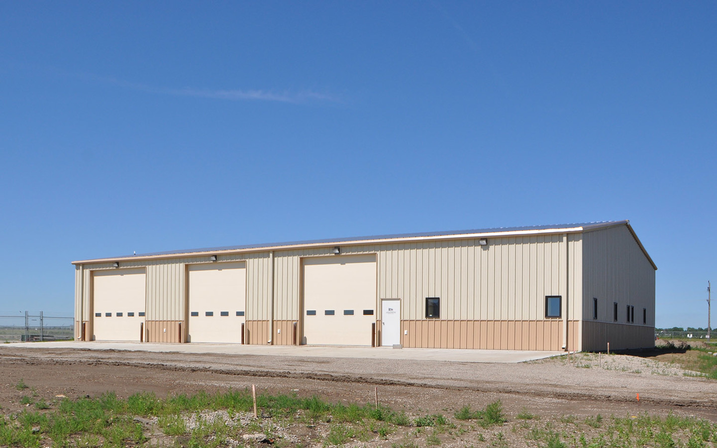
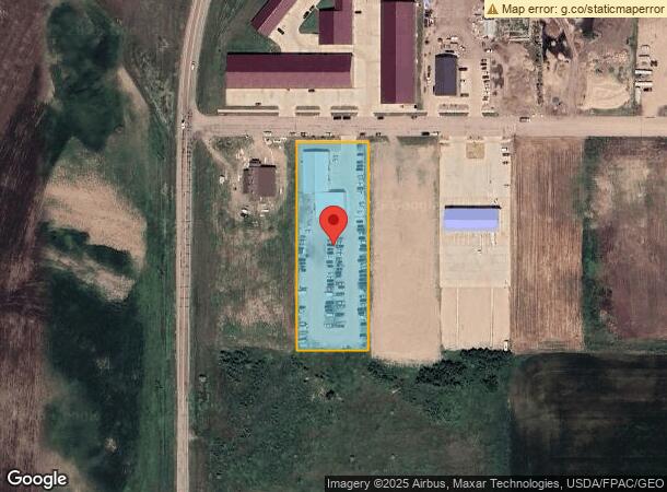
Property Record
4131 Hagen Ave, Bismarck, ND 58504
NEARBY LISTINGS FOR SALE OR LEASE
Property Detail
4131 Hagen Ave
Bismarck, ND
Hamburg Industrial Park First
2090-002-050
HAMBURG INDUSTRIAL PARK 1ST LOT 2
Lightindustrial
Burleigh
AE
North Dakota
38015C0815E
2
2023
2.04 AC
2023
East Bismarck
011300
Other Market Areas
10,200 SF
DEMOGRAPHICS near 4131 Hagen Ave
1 Mile
3 Mile
5 Mile
2024 Total Population
276
17,005
59,751
2029 Population
282
17,383
61,341
Pop Growth 2024-2029
+ 2.17%
+ 2.22%
+ 2.66%
Average Age
37
37
39
2024 Total Households
87
6,430
25,033
HH Growth 2024-2029
+ 2.30%
+ 2.32%
+ 2.76%
Median Household Inc
$87,500
$66,080
$63,339
Avg Household Size
2.80
2.40
2.20
2024 Avg HH Vehicles
2.00
2.00
2.00
Median Home Value
$361,764
$242,537
$241,989
Median Year Built
1997
1987
1978
Nearby Places
- Restaurants
- Banks
- Shops
- Fitness
- Groceries
PUBLIC TRANSPORTATION
AIRPORT
Bismarck Municipal
DRIVE
WALK
Distance
Bismarck Municipal
16 min
4.0 mi
Freight Ports
Port Milwaukee
DRIVE
WALK
Distance
Port Milwaukee
827 min
765.9 mi
SALE & LEASE HISTORY
LISTING DATE
SALE/LEASE

Oct 10, 2019
For Lease
Nov 08, 2019
For Lease
Nearby Properties
Address
Land Use
TOTAL SIZE
Lot Size
Zoning
Address
Land Use
TOTAL SIZE
Lot Size
Zoning
26.42 AC
MA
Address
Land Use
TOTAL SIZE
Lot Size
Zoning
35.42 AC
MA
Address
Land Use
TOTAL SIZE
Lot Size
Zoning
28.03 AC
MA
Address
Land Use
TOTAL SIZE
Lot Size
Zoning
6.29 AC
RM30
Address
Land Use
TOTAL SIZE
Lot Size
Zoning
20.41 AC
MA
Address
Land Use
TOTAL SIZE
Lot Size
Zoning
14.22 AC
MA
Address
Land Use
TOTAL SIZE
Lot Size
Zoning
14.70 AC
MA
Address
Land Use
TOTAL SIZE
Lot Size
Zoning
7,288 SF
7.50 AC
CG
Address
Land Use
TOTAL SIZE
Lot Size
Zoning
42,908 SF
12.44 AC
MA
Address
Land Use
TOTAL SIZE
Lot Size
Zoning
64,008 SF
12.61 AC
MA
Address
Land Use
TOTAL SIZE
Lot Size
Zoning
79,200 SF
6.01 AC
MA
Address
Land Use
TOTAL SIZE
Lot Size
Zoning
8.16 AC
MA
Address
Land Use
TOTAL SIZE
Lot Size
Zoning
56,846 SF
10.33 AC
MA
Address
Land Use
TOTAL SIZE
Lot Size
Zoning
92,982 SF
3.80 AC
RM30
Address
Land Use
TOTAL SIZE
Lot Size
Zoning
14,099 SF
5.04 AC
MA
Address
Land Use
TOTAL SIZE
Lot Size
Zoning
87,783 SF
3.86 AC
RM30
Address
Land Use
TOTAL SIZE
Lot Size
Zoning
87,783 SF
4.08 AC
RM30
Address
Land Use
TOTAL SIZE
Lot Size
Zoning
87,783 SF
3.76 AC
RM30
Address
Land Use
TOTAL SIZE
Lot Size
Zoning
92,929 SF
5.41 AC
MA
Address
Land Use
TOTAL SIZE
Lot Size
Zoning
34.07 AC
RMH
Address
Land Use
TOTAL SIZE
Lot Size
Zoning
65,160 SF
5.26 AC
MA
Address
Land Use
TOTAL SIZE
Lot Size
Zoning
11,901 SF
5.93 AC
CG
Address
Land Use
TOTAL SIZE
Lot Size
Zoning
1,569 SF
28.70 AC
RMH
Address
Land Use
TOTAL SIZE
Lot Size
Zoning
51,975 SF
4.22 AC
MA
Address
Land Use
TOTAL SIZE
Lot Size
Zoning
22,848 SF
8.70 AC
MA
Address
Land Use
TOTAL SIZE
Lot Size
Zoning
33,094 SF
4.72 AC
MA
Address
Land Use
TOTAL SIZE
Lot Size
Zoning
23,622 SF
5.07 AC
MA
Address
Land Use
TOTAL SIZE
Lot Size
Zoning
17,080 SF
11.55 AC
MA
Address
Land Use
TOTAL SIZE
Lot Size
Zoning
55,166 SF
4.82 AC
MA
Address
Land Use
TOTAL SIZE
Lot Size
Zoning
23,637 SF
4.76 AC
MA
The World's #1 Commercial Real Estate Marketplace
Connect with us
© 2025 CoStar Group
The information above has been obtained from sources believed reliable. While we do not doubt its accuracy we have not verified it and make no guarantee, warranty or representation about it. It is your responsibility to independently confirm its accuracy and completeness. Any projections, opinions, assumptions, or estimates used are for example only and do not represent the current or future performance of the property. The value of this transaction to you depends on tax and other factors which should be evaluated by your tax, financial, and legal advisors. You and your advisors should conduct a careful, independent investigation of the property to determine to your satisfaction the suitability of the property for your needs.