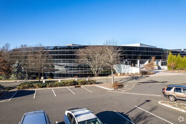
Property Record
430 Mountain Ave, New Providence, NJ 07974


Current Lease Availabilities
NEARBY LISTINGS FOR SALE OR LEASE
Property Detail
430 Mountain Ave
Newark, NJ-PA
Laurel Hill Estates Sec #8
01-03803-0000-00009
INCL BLK 3803 LOT 9 & BLK 311 LOT 5
Officebuilding
Union
X
New Jersey
34039C0008F
9
2024
24.43 AC
2025
Route 78 East
038201
Northern New Jersey
184,000 SF
DEMOGRAPHICS near 430 Mountain Ave
1 Mile
3 Mile
5 Mile
2024 Total Population
6,693
79,900
234,788
2029 Population
6,587
79,554
233,481
Pop Growth 2024-2029
(1.58%)
(0.43%)
(0.56%)
Average Age
43
41
40
2024 Total Households
2,515
27,592
81,503
HH Growth 2024-2029
(2.03%)
(0.65%)
(0.70%)
Median Household Inc
$174,377
$170,503
$146,098
Avg Household Size
2.60
2.80
2.80
2024 Avg HH Vehicles
2.00
2.00
2.00
Median Home Value
$756,430
$744,271
$716,703
Median Year Built
1962
1959
1957
Nearby Places
Map Layers
Map Styles
 Street
 Aerial
- Restaurants
- Banks
- Shops
- Fitness
- Groceries
PUBLIC TRANSPORTATION
COMMUTER RAIL
Murray Hill (Morris & Essex Gladstone Branch - NJ Transit Commuter Rail (NJ Transit))
DRIVE
WALK
Distance
Murray Hill (Morris & Essex Gladstone Branch - NJ Transit Commuter Rail (NJ Transit))
2 min
15 min
0.8 mi
New Providence (Morris & Essex Gladstone Branch - NJ Transit Commuter Rail (NJ Transit))
DRIVE
WALK
Distance
New Providence (Morris & Essex Gladstone Branch - NJ Transit Commuter Rail (NJ Transit))
4 min
2.1 mi
AIRPORT
Newark Liberty International
DRIVE
WALK
Distance
Newark Liberty International
18 min
16.6 mi
LaGuardia
DRIVE
WALK
Distance
LaGuardia
50 min
37.4 mi
Freight Ports
New York Container Terminal
DRIVE
WALK
Distance
New York Container Terminal
1 min
11.7 mi
Nearby Properties
Address
Land Use
TOTAL SIZE
Lot Size
Zoning
Address
Land Use
TOTAL SIZE
Lot Size
Zoning
Address
Land Use
TOTAL SIZE
Lot Size
Zoning
1,968 SF
88.85 AC
PROD
Address
Land Use
TOTAL SIZE
Lot Size
Zoning
Address
Land Use
TOTAL SIZE
Lot Size
Zoning
151,088 SF
26.48 AC
CCRC
Address
Land Use
TOTAL SIZE
Lot Size
Zoning
4,595 SF
4.57 AC
M-3
Address
Land Use
TOTAL SIZE
Lot Size
Zoning
7.19 AC
PI
Address
Land Use
TOTAL SIZE
Lot Size
Zoning
153.40 AC
OR
Address
Land Use
TOTAL SIZE
Lot Size
Zoning
439.33 AC
Address
Land Use
TOTAL SIZE
Lot Size
Zoning
0.42 AC
R-1
Address
Land Use
TOTAL SIZE
Lot Size
Zoning
47.69 AC
MU
Address
Land Use
TOTAL SIZE
Lot Size
Zoning
47.80 AC
H-D
Address
Land Use
TOTAL SIZE
Lot Size
Zoning
144.37 AC
Address
Land Use
TOTAL SIZE
Lot Size
Zoning
10.82 AC
H
Address
Land Use
TOTAL SIZE
Lot Size
Zoning
34.60 AC
MU
Address
Land Use
TOTAL SIZE
Lot Size
Zoning
140,732 SF
42.73 AC
OR
Address
Land Use
TOTAL SIZE
Lot Size
Zoning
19.14 AC
Address
Land Use
TOTAL SIZE
Lot Size
Zoning
56,476 SF
141.63 AC
Address
Land Use
TOTAL SIZE
Lot Size
Zoning
24.92 AC
MU
Address
Land Use
TOTAL SIZE
Lot Size
Zoning
4.36 AC
OB
Address
Land Use
TOTAL SIZE
Lot Size
Zoning
35.72 AC
PROD
Address
Land Use
TOTAL SIZE
Lot Size
Zoning
4.04 AC
B
Address
Land Use
TOTAL SIZE
Lot Size
Zoning
61,912 SF
16 AC
OR
Address
Land Use
TOTAL SIZE
Lot Size
Zoning
18.87 AC
Address
Land Use
TOTAL SIZE
Lot Size
Zoning
23.66 AC
R2
Address
Land Use
TOTAL SIZE
Lot Size
Zoning
356.94 AC
OL
Address
Land Use
TOTAL SIZE
Lot Size
Zoning
1,605 SF
2.37 AC
M-3
Address
Land Use
TOTAL SIZE
Lot Size
Zoning
117.63 AC
Address
Land Use
TOTAL SIZE
Lot Size
Zoning
36.55 AC
OL
Address
Land Use
TOTAL SIZE
Lot Size
Zoning
120 SF
9.80 AC
The World's #1 Commercial Real Estate Marketplace
Connect with us
© 2026 CoStar Group
The information above has been obtained from sources believed reliable. While we do not doubt its accuracy we have not verified it and make no guarantee, warranty or representation about it. It is your responsibility to independently confirm its accuracy and completeness. Any projections, opinions, assumptions, or estimates used are for example only and do not represent the current or future performance of the property. The value of this transaction to you depends on tax and other factors which should be evaluated by your tax, financial, and legal advisors. You and your advisors should conduct a careful, independent investigation of the property to determine to your satisfaction the suitability of the property for your needs.