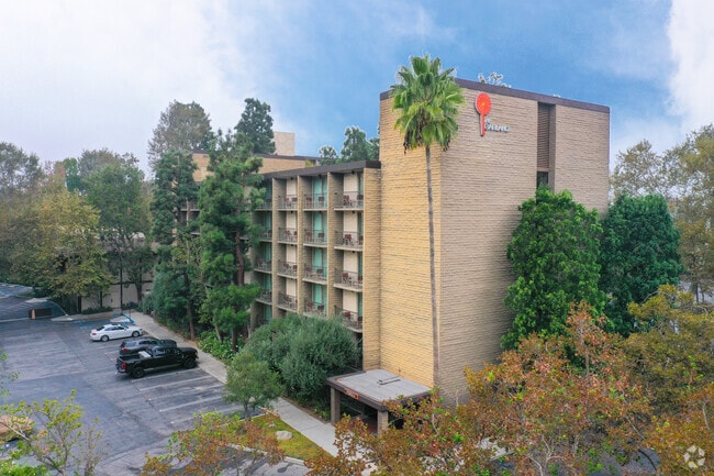
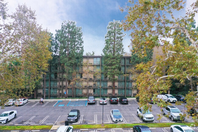
Property Record
4222 Vineland Ave, North Hollywood, CA 91602
Property Detail
4222 Vineland Ave
2366-020-002
PROPERTY OF THE LANKERSHIM RANCH LAND AND WATER CO LOT COM E ON A LINE PARALLEL WITH AND DIST S AT R/A 20 FT FROM E PROLONGATION OF S LINE OF ACAMA ST (PER M B 18-177) 8 FT FROM SW COR OF TH N THERE- ON TO BEG PART OF LOT 238
Restaurantbuilding
Los Angeles
LAC2
California
B and X Area of moderate flood hazard, usually the area between the limits of the 100-year and 500-year floods.
238
2025
1.18 AC
2025
Los Angeles North
143603
Los Angeles
32,754 SF
Los Angeles-Long Beach-Glendale, CA
NEARBY LISTINGS FOR SALE OR LEASE
-
-
View all North Hollywood listings for sale on LoopNet.com
DEMOGRAPHICS near 4222 Vineland Ave
1 mile
3 mile
5 mile
2025 Total Population
26,755
191,195
624,438
2030 Population
26,693
191,211
624,389
Pop Growth 2025-2030
(0.23%)
+ 0.01%
(0.01%)
Average Age
41
41
41
2025 Total Households
13,652
86,384
280,817
HH Growth 2025-2030
(0.46%)
(0.23%)
(0.15%)
Median Household Inc
$103,789
$98,779
$88,117
Avg Household Size
1.90
2.20
2.20
2025 Avg HH Vehicles
2.00
2.00
2.00
Median Home Value
$1,072,194
$1,073,515
$1,054,783
Median Year Built
1977
1967
1966
Nearby Places
Map Layers
Map Styles
 Street
 Aerial
Layers
 Traffic
 Biking
Places
Listings with unknown addresses are not visible on the map
- Restaurants
- Banks
- Shops
- Fitness
- Groceries
PUBLIC TRANSPORTATION
TRANSIT/SUBWAY
Universal City/Studio City (Red Line - Los Angeles County Metropolitan Transportation Authority (Metro))
Drive
Walk
Distance
Universal City/Studio City (Red Line - Los Angeles County Metropolitan Transportation Authority (Metro))
2 min
14 min
0.7 mi
COMMUTER RAIL
Burbank-Bob Hope Airport (Ventura County Line - Southern California Regional Rail Authority (Metrolink))
Drive
Walk
Distance
Burbank-Bob Hope Airport (Ventura County Line - Southern California Regional Rail Authority (Metrolink))
11 min
5.8 mi
Downtown Burbank (Antelope Valley Line - Amtrak, Pacific Surfliner - Amtrak, Ventura County Line - Amtrak)
Drive
Walk
Distance
Downtown Burbank (Antelope Valley Line - Amtrak, Pacific Surfliner - Amtrak, Ventura County Line - Amtrak)
11 min
5.9 mi
AIRPORT
Bob Hope
Drive
Walk
Distance
Bob Hope
12 min
6.3 mi
Los Angeles International
Drive
Walk
Distance
Los Angeles International
33 min
17.2 mi
Long Beach (Daugherty Field)
Drive
Walk
Distance
Long Beach (Daugherty Field)
43 min
32.9 mi
Freight Ports
Port of Long Beach
Drive
Walk
Distance
Port of Long Beach
46 min
34.4 mi
Nearby Properties
Address
Land Use
TOTAL SIZE
Lot Size
Zoning
Address
Land Use
TOTAL SIZE
Lot Size
Zoning
152,217 SF
70.95 AC
BUM1*
Address
Land Use
TOTAL SIZE
Lot Size
Zoning
735,900 SF
34.87 AC
BUPD*
Address
Land Use
TOTAL SIZE
Lot Size
Zoning
65,532 SF
67.90 AC
LAM11/2*
Address
Land Use
TOTAL SIZE
Lot Size
Zoning
21,585 SF
61.40 AC
LAM11/2*
Address
Land Use
TOTAL SIZE
Lot Size
Zoning
1,314,760 SF
33.64 AC
LAM11/2*
Address
Land Use
TOTAL SIZE
Lot Size
Zoning
207,766 SF
42.81 AC
BUM1*
Address
Land Use
TOTAL SIZE
Lot Size
Zoning
1,426,324 SF
5.96 AC
LAC2
Address
Land Use
TOTAL SIZE
Lot Size
Zoning
12,827 SF
130.37 AC
LAM11/2*
Address
Land Use
TOTAL SIZE
Lot Size
Zoning
616,662 SF
19.66 AC
BUM1*
Address
Land Use
TOTAL SIZE
Lot Size
Zoning
986,983 SF
105.50 AC
LARE40
Address
Land Use
TOTAL SIZE
Lot Size
Zoning
397,477 SF
2.75 AC
BUR4
Address
Land Use
TOTAL SIZE
Lot Size
Zoning
518,067 SF
17.27 AC
LAC4
Address
Land Use
TOTAL SIZE
Lot Size
Zoning
690,600 SF
6.57 AC
LACM
Address
Land Use
TOTAL SIZE
Lot Size
Zoning
475,433 SF
19.35 AC
BUM1*
Address
Land Use
TOTAL SIZE
Lot Size
Zoning
489,466 SF
2.90 AC
BUM1
Address
Land Use
TOTAL SIZE
Lot Size
Zoning
696,128 SF
2.42 AC
BUC3*
Address
Land Use
TOTAL SIZE
Lot Size
Zoning
43,558 SF
30.11 AC
BUMI-C2*
Address
Land Use
TOTAL SIZE
Lot Size
Zoning
529,249 SF
5.42 AC
LAC4
Address
Land Use
TOTAL SIZE
Lot Size
Zoning
219,607 SF
1.51 AC
BUR4
Address
Land Use
TOTAL SIZE
Lot Size
Zoning
380,017 SF
Address
Land Use
TOTAL SIZE
Lot Size
Zoning
354,068 SF
2.72 AC
LAR4
Address
Land Use
TOTAL SIZE
Lot Size
Zoning
80,158 SF
37.04 AC
LAM2
Address
Land Use
TOTAL SIZE
Lot Size
Zoning
336,041 SF
2.05 AC
LAC4
Address
Land Use
TOTAL SIZE
Lot Size
Zoning
440,774 SF
2.20 AC
BUR4*
Address
Land Use
TOTAL SIZE
Lot Size
Zoning
462,896 SF
1.38 AC
BUR4*
Address
Land Use
TOTAL SIZE
Lot Size
Zoning
380,276 SF
7.18 AC
LAR4
Address
Land Use
TOTAL SIZE
Lot Size
Zoning
232,965 SF
3.78 AC
LAC4
Address
Land Use
TOTAL SIZE
Lot Size
Zoning
388,171 SF
2.42 AC
LAC4
Address
Land Use
TOTAL SIZE
Lot Size
Zoning
283,018 SF
9.45 AC
LAMR2
Address
Land Use
TOTAL SIZE
Lot Size
Zoning
433,745 SF
8.59 AC
LAC2
The World's #1 Commercial Real Estate Marketplace
Connect with us
© 2026 CoStar Group
The information above has been obtained from sources believed reliable. While we do not doubt its accuracy we have not verified it and make no guarantee, warranty or representation about it. It is your responsibility to independently confirm its accuracy and completeness. Any projections, opinions, assumptions, or estimates used are for example only and do not represent the current or future performance of the property. The value of this transaction to you depends on tax and other factors which should be evaluated by your tax, financial, and legal advisors. You and your advisors should conduct a careful, independent investigation of the property to determine to your satisfaction the suitability of the property for your needs.