Property Record
4233 S Highway 61 St, Memphis, TN 38109
NEARBY LISTINGS FOR SALE OR LEASE
-
-
View all Memphis listings for sale on LoopNet.com
Property Detail
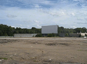
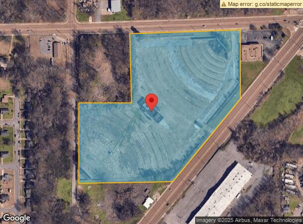
4233 S Highway 61 St
07-5116-0-0013C
Joe Youngs Re-Subdivision
Driveintheater
NW SIDE THIRD ST US HWY 61
X
Shelby
05035C0475E
Tennessee
0
17.42 AC
2024
Airport
022310
Memphis
9,876 SF
Memphis, TN-MS-AR
DEMOGRAPHICS near 4233 S Highway 61 St
1 Mile
3 Mile
5 Mile
2024 Total Population
6,110
42,921
105,507
2029 Population
5,985
42,347
106,566
Pop Growth 2024-2029
(2.05%)
(1.34%)
+ 1.00%
Average Age
39
40
39
2024 Total Households
2,264
16,268
40,598
HH Growth 2024-2029
(2.16%)
(1.46%)
+ 0.95%
Median Household Inc
$38,355
$40,097
$39,566
Avg Household Size
2.60
2.60
2.50
2024 Avg HH Vehicles
1.00
2.00
2.00
Median Home Value
$56,881
$74,095
$89,052
Median Year Built
1960
1963
1964
Nearby Places
- Restaurants
- Banks
- Shops
- Fitness
- Groceries
PUBLIC TRANSPORTATION
COMMUTER RAIL
Central Station (Riverfront Loop - Memphis Area Transit Authority Trolley (MataTrolley))
DRIVE
WALK
Distance
Central Station (Riverfront Loop - Memphis Area Transit Authority Trolley (MataTrolley))
12 min
7.5 mi
AIRPORT
Memphis International
DRIVE
WALK
Distance
Memphis International
11 min
6.9 mi
Freight Ports
Port of Shreveport
DRIVE
WALK
Distance
Port of Shreveport
407 min
374.6 mi
Nearby Properties
Address
Land Use
TOTAL SIZE
Lot Size
Zoning
Address
Land Use
TOTAL SIZE
Lot Size
Zoning
438,763 SF
64.67 AC
IH
Address
Land Use
TOTAL SIZE
Lot Size
Zoning
1,009,363 SF
78.56 AC
EMP
Address
Land Use
TOTAL SIZE
Lot Size
Zoning
214,950 SF
17.05 AC
CMU-2
Address
Land Use
TOTAL SIZE
Lot Size
Zoning
95,307 SF
25.91 AC
RU-3
Address
Land Use
TOTAL SIZE
Lot Size
Zoning
318,661 SF
26.92 AC
CMU-3
Address
Land Use
TOTAL SIZE
Lot Size
Zoning
79,658 SF
7 AC
RU-3
Address
Land Use
TOTAL SIZE
Lot Size
Zoning
79,340 SF
7 AC
RU-3
Address
Land Use
TOTAL SIZE
Lot Size
Zoning
147,890 SF
16.92 AC
EMP
Address
Land Use
TOTAL SIZE
Lot Size
Zoning
54,000 SF
293.13 AC
IH
Address
Land Use
TOTAL SIZE
Lot Size
Zoning
233,060 SF
20 AC
EMP
Address
Land Use
TOTAL SIZE
Lot Size
Zoning
37,631 SF
3.38 AC
CMU-2
Address
Land Use
TOTAL SIZE
Lot Size
Zoning
13,978 SF
7 AC
RU-3
Address
Land Use
TOTAL SIZE
Lot Size
Zoning
12,789 SF
19.12 AC
RU-1
Address
Land Use
TOTAL SIZE
Lot Size
Zoning
370,000 SF
20.28 AC
EMP
Address
Land Use
TOTAL SIZE
Lot Size
Zoning
33,098 SF
39.07 AC
EMP
Address
Land Use
TOTAL SIZE
Lot Size
Zoning
35,280 SF
5.80 AC
CMU-3
Address
Land Use
TOTAL SIZE
Lot Size
Zoning
128,704 SF
7.98 AC
RU-3
Address
Land Use
TOTAL SIZE
Lot Size
Zoning
91,965 SF
14.64 AC
RU-3
Address
Land Use
TOTAL SIZE
Lot Size
Zoning
27,084 SF
3.26 AC
CMU-1
Address
Land Use
TOTAL SIZE
Lot Size
Zoning
104,069 SF
12.50 AC
RU-3
Address
Land Use
TOTAL SIZE
Lot Size
Zoning
31,164 SF
3.08 AC
CMU-1
Address
Land Use
TOTAL SIZE
Lot Size
Zoning
8,568 SF
102.43 AC
R-6
Address
Land Use
TOTAL SIZE
Lot Size
Zoning
23,860 SF
11.54 AC
R-6
Address
Land Use
TOTAL SIZE
Lot Size
Zoning
21,140 SF
7.53 AC
CMU-3
Address
Land Use
TOTAL SIZE
Lot Size
Zoning
20,600 SF
2.77 AC
CMU-1
Address
Land Use
TOTAL SIZE
Lot Size
Zoning
16,246 SF
10.08 AC
CMU-2
Address
Land Use
TOTAL SIZE
Lot Size
Zoning
504,925 SF
43.01 AC
EMP
Address
Land Use
TOTAL SIZE
Lot Size
Zoning
23,513 SF
0.98 AC
CMU-3
Address
Land Use
TOTAL SIZE
Lot Size
Zoning
14,308 SF
2.94 AC
R-10
Address
Land Use
TOTAL SIZE
Lot Size
Zoning
18,218 SF
1.14 AC
CMU-3
The World's #1 Commercial Real Estate Marketplace
Connect with us
© 2025 CoStar Group
The information above has been obtained from sources believed reliable. While we do not doubt its accuracy we have not verified it and make no guarantee, warranty or representation about it. It is your responsibility to independently confirm its accuracy and completeness. Any projections, opinions, assumptions, or estimates used are for example only and do not represent the current or future performance of the property. The value of this transaction to you depends on tax and other factors which should be evaluated by your tax, financial, and legal advisors. You and your advisors should conduct a careful, independent investigation of the property to determine to your satisfaction the suitability of the property for your needs.